Cape Tribulation, Queensland
| Cape Tribulation Queensland | |||||||||||||||
|---|---|---|---|---|---|---|---|---|---|---|---|---|---|---|---|
 Cape Tribulation | |||||||||||||||
 Cape Tribulation | |||||||||||||||
| Coordinates | 16°02′05″S 145°25′09″E / 16.0347°S 145.4191°ECoordinates: 16°02′05″S 145°25′09″E / 16.0347°S 145.4191°E | ||||||||||||||
| Population | 118 (2016 census)[1] | ||||||||||||||
| • Density | 0.897/km2 (2.324/sq mi) | ||||||||||||||
| Established | 1930s | ||||||||||||||
| Postcode(s) | 4873 | ||||||||||||||
| Area | 131.5 km2 (50.8 sq mi) | ||||||||||||||
| LGA(s) | Shire of Douglas | ||||||||||||||
| State electorate(s) | Cook | ||||||||||||||
| Federal Division(s) | Leichhardt | ||||||||||||||
| |||||||||||||||
Cape Tribulation is a headland and locality in the Shire of Douglas in northern Queensland, Australia.[2][3][4] At the 2011 census, Cape Tribulation had a population of 330.[1]
Geography
The locality is 110 km (68 mi) north of Cairns. It is within the Daintree National Park and the Wet Tropics World Heritage area. It is within the local government area of Shire of Douglas (between 2008 and 2013, it was within the Cairns Region).
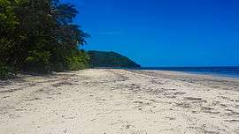
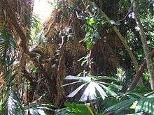
The locality contains a small number of bed and breakfast eco lodges, tourism resorts and backpacker hostels. A few very rare plants can be found on Cape Tribulation.[5]
History
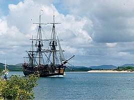
Cape Tribulation was named by British navigator Lieutenant James Cook on 10 June 1770 (log date) after his ship scraped a reef north east of the cape, whilst passing over it, at 6pm. Cook steered away from the coast into deeper water but at 10.30pm the ship ran aground, on what is now named Endeavour Reef. The ship stuck fast and was badly damaged, desperate measures being needed to prevent it foundering until it was refloated the next day. Cook recorded "...the north point [was named] Cape Tribulation because "here begun all our troubles".[6]
In the 1930s some European settlers started arriving in Cape Tribulation, but they found the rainforest environment an extremely challenging one within which to establish a settlement. Various ventures such as fruit and vegetable farming, fishing, cattle, and timber cutting were started and abandoned over the years, and having weekly barges as the only transport in and out was another limitation. In the 1960s a rough track was bulldozed and the first vehicle access created, although the road remained a four-wheel drive track until the early 1990s. In 2002, the road was finally sealed all the way to Cape Tribulation and in early 2011 the last bridge was built creating year round all weather access to Cape Tribulation for the first time.[7]
Protests
In 1983, Cape Tribulation became widely known because of the blockade on the Bloomfield Track. Local government had decided to bulldoze a road through the rainforest north of Cape Tribulation to complete the coastal road to Cooktown. Protesters tried to stop the bulldozers and occupied trees to prevent their destruction.[8] While wild scenes with a large police and media presence ensued at the southern end, the road was completed in three short weeks as the road builders approached from northern end and flanked the protestors.[9] By now the state and federal governments had started to realise the value of this ancient rainforest and despite protests from the local council the forests surrounding Cape Tribulation were given World Heritage Listing in 1988.[10]
Tourist destination

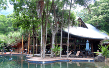
From the mid-1980s the first backpackers hostels started getting built, and in the 1990s some more resorts for the more upmarket tourists. Nowadays there are also several small owner operated Bed and Breakfast eco lodges hidden away in the rainforest. Compared to a lot of famous tourist destinations along coastal Queensland, Cape Tribulation is still an off the beaten track destination.
Most people visit the area during the dry season between July and November. During the wet season marine stingers are prevalent causing locals and visitors to swim in the many creeks that are not home to estuary crocodiles. There are four main resorts in the area catering to backpackers and more upmarket tourists, and some unique rainforest bed and breakfasts.
Climate
The average annual rainfall for Cape Tribulation is 3,900 mm.[11] In 2006, the rainfall recorded was over 6.5 m (256 in) and in 2010 it reached 8 metres.
Access
A sealed road provides access to the area from the south via the Daintree River Ferry and with the completion of the Cooper Creek bridge access is now year round all weather. North from Cape Tribulation Beach House, a four-wheel drive unsealed road, known as the Bloomfield Track, continues to the Bloomfield River, Wujal Wujal, Bloomfield Falls and Cooktown and is often closed during the wet season (February to April).
Activities
The Great Barrier Reef is some 19 km (12 mi) due east; there is a boat charter that leaves from the beach at Cape Tribulation. Other activities available are 4WD tours, horse-riding, jungle surfing, exotic fruit tasting tours, electric mountain bike tours, guided nightwalks and crocodile cruises.
The Daintree Entomological Museum showcasing the butterfly and beetle collection of lifelong collector Steve Lamond is located 15 kilometres (9.3 mi) south of Cape Tribulation.
Cape Tribulation also has the only Conspiracy Museum in the world, where a local residents has compiled evidence and historical documents showing how for decades various governments and other individuals and organisations have made life hard for the Daintree community to discourage settlement and tried to drive them off their land. The museum is located in the Rainforest Hideaway B&B which also has an interesting rain forest sculpture trail.
Walking tracks
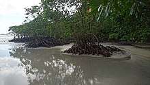
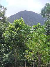
The area has a number of walking tracks ranging from easy to difficult.[12] The Dubuji Boardwalk is a walking trail from the main highway to the beach that has toilet and picnic facilities. It leads mainly through swampland with many mangroves. A characteristic of this walk are the tree trunks the path is built around. The Mount Sorrow ridge trail is a seven-hour walk which leads to a lookout with expansive views.[12]
See also
References
- 1 2 Australian Bureau of Statistics (25 October 2007). "Cape Tribulation (Douglas Shire) (State Suburb)". 2006 Census QuickStats. Retrieved 13 December 2013.
- ↑ "Cape Tribulation". Gazetteer of Australia online. Geoscience Australia, Australian Government.
- ↑ "Cape Tribulation - headland in Shire of Douglas (entry 35179)". Queensland Place Names. Queensland Government. Retrieved 29 June 2017.
- ↑ "Cape Tribulation - locality in the Shire of Douglas (entry 48561)". Queensland Place Names. Queensland Government. Retrieved 29 June 2017.
- ↑ "About Cape Tribulation". Department of Environment and Resource Management. 6 April 2011. Archived from the original on 15 September 2011. Retrieved 29 June 2011.
- ↑ "Cook's Journal: Daily Entries". Retrieved 2 February 2018.
- ↑ "Mayor Val Schier opened the Cooper Creek Causeway". Stonewood Retreat. Retrieved 11 August 2014.
- ↑ Lines, William J. (1991). Taming the Great South Land: A History of the Conquest of Nature in Australia. University of South California Press. p. 257. ISBN 0-520-07830-6.
- ↑ Lines, Nielsen L. (1997). Daintree – Jewel of Tropical North Queensland. Lloyd Nielsen.
- ↑ "Wet Tropics of Queensland". World Heritage Conservation. UNESCO. Retrieved 11 August 2014.
- ↑ Shilton, Peter (2005). Natural Areas of Queensland. Mount Gravatt, Queensland: Goldpress. p. 52. ISBN 0-9758275-0-2.
- 1 2 Cape Tribulation, Daintree National Park. Department of National Parks, Recreation, Sport and Racing. Retrieved 6 January 2014.
External links
| Wikimedia Commons has media related to Cape Tribulation, Queensland. |