Yungaburra
| Yungaburra Queensland | |||||||||||||||
|---|---|---|---|---|---|---|---|---|---|---|---|---|---|---|---|
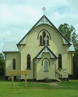 St Patrick's Catholic Church (built 1914) | |||||||||||||||
 Yungaburra Location in Queensland | |||||||||||||||
| Coordinates | 17°16′16″S 145°34′59″E / 17.27111°S 145.58306°ECoordinates: 17°16′16″S 145°34′59″E / 17.27111°S 145.58306°E | ||||||||||||||
| Population | 1,106 (2011 census)[1] | ||||||||||||||
| Established | 1886[2] | ||||||||||||||
| Postcode(s) | 4884 | ||||||||||||||
| Elevation | 750 m (2,461 ft) | ||||||||||||||
| Location | |||||||||||||||
| LGA(s) | Tablelands Region | ||||||||||||||
| State electorate(s) | Hill | ||||||||||||||
| Federal Division(s) | Kennedy | ||||||||||||||
| |||||||||||||||
| |||||||||||||||
Yungaburra is a town located on the Atherton Tableland in Far North Queensland, Australia, not far from Cairns. In the 2011 census, Yungaburra had a population of 1,116 people.[1]
Name
The name 'Yungaburra' comes from the local Yidiny word janggaburru, denoting the Queensland silver ash (Flindersia bourjotiana).[3]
History
Prior to European settlement the area around Yungaburra was inhabited by about sixteen different indigenous groups, among them the Ngatjan, with the custodians being Yidinji people and neighbouring Ngajanji people. The Queensland police and native troops carried out extensive massacres in the area to rid it of blacks. In one incident in 1884, at Skull Pocket just north of the town, a group of Yidinji were surrounded at night, and at dawn mowed down after they fled on hearing the first shot. The children were brained or stabbed to death by native troopers.[4]
In the early 1880s the area around Allumbah Pocket was used as an overnight stop for miners travelling west from the coast. In 1886 the land was surveyed, and in 1891 settlers moved in.
In 1910 the railway arrived, and the town was renamed Yungaburra, to avoid confusion with another town called Allumbah.
By 1911 indigenous numbers had fallen to 20% of the pre-settlement population due to disease, conflict with settlers and loss of habitat.
At the 2006 census, Yungaburra had a population of 932.[5]
Cyclone Larry
In 2006, The Atherton Tableland region was damaged by the Category 4 (on the Australian scale) Cyclone Larry. Of the 19 heritage listed sites in Yungaburra, only the roofs of the community hall, police station and one of the bush cottages were badly damaged, as were the front of the Yungaburra Butchery and Gem Gallery sign. The town was restored very quickly; little evidence of the cyclone is visible.
Heritage listings
Yungaburra has a number of heritage-listed sites, including:
- 27 Atherton Road: Bank of New South Wales[6]
- 6-10 Cedar Street: Yungaburra Court House[7]
- 7-9 Cedar Street: 7-9 Cedar Street, Yungaburra[8]
- 12 Cedar Street: Residence[9]
- 15-17 Cedar Street: Yungaburra Post Office[10]
- 16-20 Cedar Street: Williams' House[11]
- 19 Cedar Street: Yungaburra Community Centre[12]
- 32 Cedar: Billy Madrid's House[13]
- 34 Cedar Street: Barber's Shop, Yungaburra[14]
- Curtain Fig Tree Road: Curtain Fig Tree[15]
- 7 Eacham Road: St Marks Anglican Church[16]
- 25-33 Eacham Road: Cairns Plywood Pty Ltd Sawmill Complex[17]
- 20 Gillies Highway: Eden House Restaurant[18]
- 2 Kehoe Place: Butchers Shop[19]
- 6-8 Kehoe Place: Lake Eacham Hotel[20]
- 7 Mulgrave Road: Allumbah[21]
- 4 Oak Street: Residence[22]
- 1 Penda Street: St Patricks Catholic Church[23]
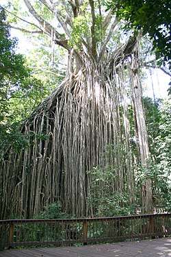 Curtain Fig Tree
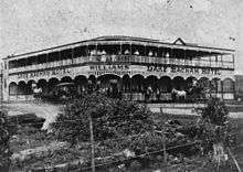 Lake Eacham Hotel
- The Afghanistan Avenue of Honour, on the Shores of Lake Tinaroo
Present day
Yungaburra's economy today revolves around tourism, and the town contains a primary school, post office, library/telecentre and a range of businesses and services for the use of residents and visitors. Other facilities include a tennis court and a bowling club.The town has 18 Heritage Listed buildings, and is the largest National Trust village in Queensland. The Yungaburra Markets, held on the fourth Saturday of each month, are one of the largest in Far North Queensland, and each year around the end of October, Yungaburra holds the two-day Yungaburra Folk Festival, featuring concerts from Australian (and sometimes international) folk musicians. Yungaburra is also the site of the war memorial to soldiers lost, opened 22 June 2013. The population of Yungaburra is 1,034 persons as of 30 June 2009. There is a network of walking tracks around the town including Peterson's Creek.
Geography
The landscape around Yungaburra has been shaped by millennia of volcanic activity. The most recent eruptions were approximately 10,000 years ago. Notable geological features nearby include:
- Seven Sisters and Mount Quincan are volcanic cones.
- Lake Eacham (Yidyam) and Lake Barrine are lakes inside volcanic craters.
- Mount Hypipamee Crater is a diatreme (crater).
- Tinaroo Dam submerged the old town of Kulara is visible, on whose cricket-pitch, when drought conditions drastically lower the water-level, locals play cricket matches.[24]
Tourism
Allumbah Pocket is a picnic area on Petersons Creek which runs past Yungaburra. It is the centre for a series of walking tracks along the creek. Tracks lead to Frawley's Pool, a popular swimming hole and picnic area, then further to Yungaburra's historical train bridge. In the opposite direction there is a track to the platypus viewing deck. Aside from this all of the tracks are relatively easy and short enough for anyone to do. The site is dedicated to Geoff Tracy, a local renowned environmentalist who died in 2004.
Yungaburra has access to the southern arm of Lake Tinaroo which is popular for fishing, canoeing, sailing, swimming, water-skiing and camping. The other main places to get to Tinaroo are Kairi and the township of Tinaroo.
The Curtain Fig Tree, which is just out of Yungaburra, is a giant rainforest fig tree with roots hanging down, giving it the appearance of curtains. There is a short boardwalk around the tree.
Lake Barrine and Lake Eacham are crater lakes, formed from volcanoes. Lake Eacham is popular for swimming and Lake Barrine has a teahouse and gift shop as well as cruises around the lake however is unsuitable for swimming due to the cruise boats. Both lakes have walking tracks around them. Lake Barrine's track is 6 kilometres (3.7 mi) and Lake Eacham's is 3 kilometres (1.9 mi).
There are a number of places to dine, from Takeaway to fine dining.
Facilities
Yungaburra has a library at Maud Kehoe Park operateydby the Tablelands Regional Council.[25]
Notable residents
- George Alfred Duffy (1887-1941), Member of the Queensland Legislative Assembly for Eacham
- Edward Stratten Williams (1921-1999), judge of the Supreme Court of Queensland
Notes and references
Notes
- 1 2 Australian Bureau of Statistics (31 October 2012). "Yungaburra (SSC)". 2011 Census QuickStats. Retrieved 6 June 2016.

- ↑ "Archived copy". Archived from the original on 29 October 2010. Retrieved 17 October 2010.
- ↑ Dixon 1991, p. 25.
- ↑ Bottoms 2013, pp. 217-218.
- ↑ Australian Bureau of Statistics (25 October 2007). "Yungaburra (Urban Centre/Locality)". 2006 Census QuickStats. Retrieved 25 June 2011.
- ↑ "27 Atherton Road, Yungaburra (entry 600468)". Queensland Heritage Register. Queensland Heritage Council. Retrieved 14 July 2013.
- ↑ "Court House, Police Station and Residence (entry 600477)". Queensland Heritage Register. Queensland Heritage Council. Retrieved 14 July 2013.
- ↑ "7-9 Cedar Street, Yungaburra (entry 600480)". Queensland Heritage Register. Queensland Heritage Council. Retrieved 14 July 2013.
- ↑ "Residence (entry 600476)". Queensland Heritage Register. Queensland Heritage Council. Retrieved 14 July 2013.
- ↑ "Yungaburra Post Office and residence (entry 600471)". Queensland Heritage Register. Queensland Heritage Council. Retrieved 14 July 2013.
- ↑ "Residence 16-20 Cedar Street (entry 600472)". Queensland Heritage Register. Queensland Heritage Council. Retrieved 14 July 2013.
- ↑ "Community Centre (entry 600479)". Queensland Heritage Register. Queensland Heritage Council. Retrieved 14 July 2013.
- ↑ "Special Glass Co. Shop (entry 600478)". Queensland Heritage Register. Queensland Heritage Council. Retrieved 14 July 2013.
- ↑ "Burra Inn Restaurant (entry 600470)". Queensland Heritage Register. Queensland Heritage Council. Retrieved 14 July 2013.
- ↑ "The Curtain Fig Tree (entry 602734)". Queensland Heritage Register. Queensland Heritage Council. Retrieved 14 July 2013.
- ↑ "St Marks Anglican Church (entry 600484)". Queensland Heritage Register. Queensland Heritage Council. Retrieved 14 July 2013.
- ↑ "Cairns Plywood Pty Ltd Sawmill Complex (entry 600481)". Queensland Heritage Register. Queensland Heritage Council. Retrieved 14 July 2013.
- ↑ "Eden House Restaurant (entry 600467)". Queensland Heritage Register. Queensland Heritage Council. Retrieved 14 July 2013.
- ↑ "Butchers Shop (entry 600482)". Queensland Heritage Register. Queensland Heritage Council. Retrieved 14 July 2013.
- ↑ "Lake Eacham Hotel (entry 600473)". Queensland Heritage Register. Queensland Heritage Council. Retrieved 14 July 2013.
- ↑ "Allumbah (entry 600486)". Queensland Heritage Register. Queensland Heritage Council. Retrieved 14 July 2013.
- ↑ "Residence (entry 600487)". Queensland Heritage Register. Queensland Heritage Council. Retrieved 14 July 2013.
- ↑ "St Patricks Catholic Church (entry 600488)". Queensland Heritage Register. Queensland Heritage Council. Retrieved 14 July 2013.
- ↑ Geiger 2016.
- ↑ "Yungaburra Library". plconnect.slq.qld.gov.au. State Library of Queensland. Retrieved 2018-01-22.
References
- Bottoms, Timothy (2013). Conspiracy of Silence (PDF). Allen & Unwin. ISBN 978-1-743-31382-4.
- Dixon, Robert M. W. (1991). Words of Our Country: Stories, place names and vocabulary in Yidiny, the Aboriginal language of the Cairns-Yarrabam region (PDF). University of Queensland Press. ISBN 0 7022 2360 3.
- Geiger, Dominic (20 December 2016). Cricket match planned for middle of dry Tinaroo dam. Cairns Post.
External links
| Wikimedia Commons has media related to Yungaburra. |