Shire of Livingstone
| Shire of Livingstone Queensland | |||||||||||||||
|---|---|---|---|---|---|---|---|---|---|---|---|---|---|---|---|
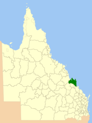 Location within Queensland | |||||||||||||||
| Population | 36,272 (2016 census)[1] | ||||||||||||||
| • Density | 3.08008/km2 (7.97738/sq mi) | ||||||||||||||
| Established | 2014 | ||||||||||||||
| Area | 11,776.3 km2 (4,546.9 sq mi) | ||||||||||||||
| Mayor | Bill Ludwig | ||||||||||||||
| Council seat | Yeppoon | ||||||||||||||
| Region | Central Queensland | ||||||||||||||
|
| |||||||||||||||
| Website | Shire of Livingstone | ||||||||||||||
| |||||||||||||||
The Shire of Livingstone is a local government area located in the Capricornia region of Central Queensland, Queensland, Australia, to the immediate north and east of the regional city of Rockhampton. The shire, administered from the coastal town of Yeppoon, covers an area of 11,776.3 square kilometres (4,546.9 sq mi), and existed as a local government entity from 1879 until 2008, when it amalgamated with several other councils to become the Rockhampton Region. The Shire was re-established on 1 January 2014 following a successful de-amalgamation referendum in 2013.
Industry within the shire is diverse. Timber is harvested from extensive pine plantations near Byfield in the north. Significant pineapple production takes place within the shire, as well as other agricultural crops. Tourism is increasingly becoming a mainstay of the area, with Keppel Bay and the nearby islands a major drawcard, and more than half of the Shire's population lives in the coastal area centred on Yeppoon and Emu Park. The coastal strip within the shire is known as the Capricorn Coast.[2] The Shoalwater Bay Military Training Area is also located within the shire.
History
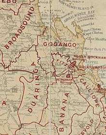
On 11 November 1879, the Gogango Division was established as one of 74 divisions around Queensland under the Divisional Boards Act 1879 with a population of 5023.[3][4] It covered an area of 16,239 km2 (6,270 sq mi) surrounding but not including the town of Rockhampton—an area significantly greater than the modern Rockhampton Regional Council covers. Its administrative centre was in North Rockhampton.
Capital and people came to the area in greater numbers after the discovery of gold in 1882 at Mount Morgan, about 20 kilometres (12 mi) south of Rockhampton.
A bridge was built spanning the Fitzroy River in 1882, and a year later in September 1883, the Borough of North Rockhampton was proclaimed.
On 3 March 1892, part of subdivision 2 of the Broadsound Division was transferred to subdivision 3 of the Gogango Division, while another part of subdivision 2 of the Broadsound Division was transferred to the Duaringa Division.[5]
On 6 April 1899, the part of the Gogango Division south of the Fitzroy River split away to form the Fitzroy Division.[6]
With the passage of the Local Authorities Act 1902, Gogango Division became the Shire of Gogango on 31 March 1903, and on 8 August 1903 it was renamed Shire of Livingstone.[7][8]
On 1 July 1984, the neighbouring City of Rockhampton grew to include some of its outer suburbs which had previously been within the Shire of Livingstone.
On 15 March 2008, under the Local Government (Reform Implementation) Act 2007 passed by the Parliament of Queensland on 10 August 2007, the Shire of Livingstone merged with the City of Rockhampton and the Shires of Mount Morgan and Fitzroy to form the Rockhampton Region.[8][9]
In 2012, a proposal was made to de-amalgamate the Shire of Livingstone from the Rockhampton Region.[10] On 9 March 2013, the citizens of the former Livingstone shire voted in a referendum to de-amalgamate. The Shire of Livingstone was re-established on 1 January 2014.[11][12]
Towns and localities
The Shire of Livingstone includes the following settlements:
|
Rockhampton area:
|
Yeppoon-Keppel area:
|
Other areas:
|
|
1 - shared with Rockhampton Region
2 - not to be confused with Bangalee in the Gladstone Region
3 - not to be confused with Maryvale in the Southern Downs Region
Libraries
The Livingstone Shire Council operates public libraries in Byfield, Marlborough, Emu Park, and Yeppoon. It also supports volunteer-operated libraries in Mount Chalmers and Stanage Bay.[13]
Population
| Year | Population |
|---|---|
| 1933 | 6,472 |
| 1947 | 6,452 |
| 1954 | 7,031 |
| 1961 | 7,320 |
| 1966 | 7,780 |
| 1971 | 9,595 |
| 1976 | 11,634 |
| 1981 | 15,711 |
| 1986 | 15,886 |
| 1991 | 19,334 |
| 1996 | 24,796 |
| 2001 | 27,017 |
| 2006 | 28,870 |
Chairmen and mayors
The following were the chairmen and mayors of the Shire of Livingstone in its first incarnation:
- 1927: W. Beak[14]
- 1933-1936 Owen Daniel[15]
- John Murray[16]
- 1983: Lindsay Hartwig served for one year[17]
- The following were the mayors of Shire of Livingstone in its second incarnation:
- 2014—2016 : Bill Ludwig[18]
- 2016-: Bill Ludwig[19]
References
- ↑ Australian Bureau of Statistics (27 June 2017). "Livingstone (S)". 2016 Census QuickStats. Retrieved 26 November 2017.

- ↑ "Capricorn Coast - district (entry 6158)". Queensland Place Names. Queensland Government. Retrieved 6 April 2017.
- ↑ "Proclamation [Gogango Division]". Queensland Government Gazette. 11 November 1879. p. 25:1004.
- ↑ "Agency ID896, Gogango Divisional Board". Queensland State Archives. Retrieved 20 September 2013.
- ↑ "Order in Council [Broadsound, Gogango and Duaringa Divisions]". Queensland Government Gazette. 5 March 1892. p. 55:920.
- ↑ "Agency ID243, Fitzroy Divisional Board". Queensland State Archives. Retrieved 20 September 2013.
- ↑ "Agency ID897, Gogango Shire Council". Queensland State Archives. Retrieved 20 September 2013.
- 1 2 "Agency ID1139, Livingstone Shire Council". Queensland State Archives. Retrieved 24 September 2013.
- ↑ "Agency ID11047, Rockhamption Regional Council". Queensland State Archives. Retrieved 24 September 2013.
- ↑ "Capricorn Coast Regional Council & Rockhampton Regional Council: a Partnership Approach for Sound Regional Governance: Unity and strength with community of interest representation: De-amalgamation Submission to the Queensland Boundary Commissioner August 2012" (PDF). Archived from the original (PDF) on 28 April 2013. Retrieved 14 August 2013.
- ↑ "De-amalgamation". Queensland Government. Archived from the original on 26 August 2013. Retrieved 14 August 2013.
- ↑ "Local Government (De-amalgamation Implementation) Regulation 2013" (PDF). Local Government Act 2009. Queensland Government. Archived (PDF) from the original on 26 May 2013. Retrieved 14 August 2013.
- ↑ "Libraries". Livingstone Shire Council. Archived from the original on 1 February 2018. Retrieved 1 February 2018.
- ↑ Pugh, Theophilus Parsons (1927). Pugh's Almanac for 1927. Archived from the original on 4 March 2014. Retrieved 13 June 2014.
- ↑ Daniel, Mr Owen Archived 1 July 2016 at the Wayback Machine. — Queensland Parliament. Retrieved 19 May 2016.
- ↑ McDonald, Lorna L. "Murray, John (1837–1917)". Australian Dictionary of Biography. National Centre for Biography, Australian National University. Archived from the original on 29 December 2013. Retrieved 26 December 2013.
- ↑ "Hartwig, Mr Lindsay Earle". Re-Member Database. Queensland Parliament. Archived from the original on 24 September 2015. Retrieved 18 June 2014.
- ↑ "2013 Livingstone Shire Council – Mayoral Election". Electoral Commission of Queensland. Archived from the original on 25 February 2014. Retrieved 20 February 2014.
- ↑ "2016 Livingstone Shire Council - Mayoral Election - Election Summary". results.ecq.qld.gov.au. Archived from the original on 27 March 2018. Retrieved 4 December 2017.
Coordinates: 23°07′44.3″S 150°44′41.5″E / 23.128972°S 150.744861°E