Shire of Flinders (Queensland)
| Shire of Flinders Queensland | |||||||||||||||
|---|---|---|---|---|---|---|---|---|---|---|---|---|---|---|---|
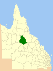 Location within Queensland | |||||||||||||||
| Population | 1,536 (2016 census)[1] | ||||||||||||||
| • Density | 0.036978/km2 (0.095772/sq mi) | ||||||||||||||
| Established | 1882 | ||||||||||||||
| Area | 41,538.5 km2 (16,038.1 sq mi) | ||||||||||||||
| Mayor | Jane McNamara | ||||||||||||||
| Council seat | Hughenden | ||||||||||||||
| Region | North West Queensland | ||||||||||||||
| State electorate(s) | Traeger | ||||||||||||||
| Federal Division(s) | Kennedy | ||||||||||||||
|
| |||||||||||||||
| Website | Shire of Flinders | ||||||||||||||
| |||||||||||||||
The Shire of Flinders is a local government area in north-western Queensland, Australia.
It covers an area of 41,538.5 square kilometres (16,038.1 sq mi), and has existed as a local government entity since 1882. The Shire, named for the Flinders River, is predominantly a grazing area with cattle in the north of the shire and mixed grazing to the south in the black soil area.
History
The Hughenden Division was established on 20 July 1882 under the Divisional Boards Act 1879.[2] On 20 April 1887, the Borough of Hughenden was constituted separately as a municipality for the emerging town of Hughenden.[3]
On 31 March 1903, the Hughenden Division became the Shire of Hughenden and the Borough of Hughenden became the Town of Hughenden under the Local Authorities Act 1902.[4] On 5 September of the same year, the Shire of Hughenden was renamed Shire of Flinders.[5]
The western part of the Shire was separately incorporated as the Shire of Wyangarie (later Shire of Richmond) on 23 October 1915. On 1 January 1930, part of the Shire of Flinders was annexed to the Shire of Dalrymple.[6]
In 1958, the Town of Hughenden amalgamated with the Shire of Flinders.[4][7]
Towns and localities
The Shire of Flinders includes the following settlements:
- Hughenden
- Dutton River
- Marathon
- Porcupine
- Prairie
- Stamford
- Tangorin
- Torrens Creek
Amenities
The Flinders Shire Council operate the Flinders Shire Library at 39 Gray Street, Hughenden.[8]
Population
| Year | Population |
|---|---|
| 1933 | 3,426‡ |
| 1947 | 3,310‡ |
| 1954 | 3,293‡ |
| 1961 | 3,953 |
| 1966 | 3,716 |
| 1971 | 3,019 |
| 1976 | 2,875 |
| 1981 | 2,740 |
| 1986 | 2,804 |
| 1991 | 2,491 |
| 1996 | 2,232 |
| 2001 | 2,191 |
| 2006 | 1,792 |
| 2011 | 1791 |
| 2016 | 1,536 |
- ‡ – includes then-separate Town.
Chairmen and mayors
References
- ↑ Australian Bureau of Statistics (27 June 2017). "Flinders (S)". 2016 Census QuickStats. Retrieved 4 May 2018.

- ↑ "Proclamation [Hughenden Division]". Queensland Government Gazette. 22 July 1882. p. 31:201.
- ↑ "Current News". The Queenslander. 7 May 1887. p. 725. Retrieved 11 September 2013 – via National Library of Australia.
- 1 2 "Agency ID2251, Hughenden Town Council". Queensland State Archives. Retrieved 11 September 2013.
- ↑ "Agency ID887, Flinders Shire". Queensland State Archives. Retrieved 11 September 2013.
- ↑ "Order in Council". Queensland Government Gazette. 21 December 1929. p. 133:2125.
- ↑ Flinders Shire Council (2008). "History of Council". Archived from the original on April 10, 2013. Retrieved 30 October 2009.
- ↑ "Flinders Shire Council". Public Libraries Connect. State Library of Queensland. 20 September 2017. Archived from the original on 6 February 2018. Retrieved 6 February 2018.
- ↑ Consolidated Index to Queensland Government Gazette 1859-1919. Queensland Family History Society. 2004. ISBN 1 876613 79 3.
- ↑ Pugh, Theophilus Parsons (1927). Pugh's Almanac for 1927. Retrieved 13 June 2014.
- ↑ "2008 Flinders Shire - Mayoral Election - Election Summary". results.ecq.qld.gov.au. Retrieved 2017-12-04.
- ↑ "2012 Flinders Shire - Mayoral Election - Election Summary". Electoral Commission of Queensland. Archived from the original on 12 June 2017. Retrieved 12 June 2017.
- ↑ "2016 Flinders Shire Council - Mayoral Election - Election Summary". Electoral Commission of Queensland. Archived from the original on 12 June 2017. Retrieved 12 June 2017.
External links
Coordinates: 20°50′34″S 144°12′02″E / 20.84278°S 144.20056°E