City of Busselton
| City of Busselton Western Australia | |||||||||||||||
|---|---|---|---|---|---|---|---|---|---|---|---|---|---|---|---|
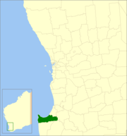 Location in Western Australia | |||||||||||||||
| Population | 36,686 (2016 census)[1] | ||||||||||||||
| • Density | 25.2172/km2 (65.3123/sq mi) | ||||||||||||||
| Established | 1951 | ||||||||||||||
| Area | 1,454.8 km2 (561.7 sq mi) | ||||||||||||||
| Mayor | Grant Henley[2] | ||||||||||||||
| Council seat | Busselton | ||||||||||||||
| Region | South West | ||||||||||||||
| State electorate(s) | Vasse | ||||||||||||||
| Federal Division(s) | Forrest | ||||||||||||||
|
| |||||||||||||||
| Website | City of Busselton | ||||||||||||||
| |||||||||||||||
The City of Busselton is a local government area in the South West region of Western Australia, approximately 230 km (143 mi) south of Perth, the state capital. The city covers an area of 1,455 km2 (562 sq mi) and had a population of 36,686 as at the 2016 Census. It contains two large towns, Busselton and Dunsborough, and a number of smaller towns. The city office is located on Southern Drive, Busselton.
History
The City of Busselton began in 1871 as two entities - the Busselton Municipal District, governing the town of Busselton, and the Sussex Road District, governing the rural area. The two merged in 1951 to become the Busselton Road District. On 1 July 1961, the Road District became a shire.[3] On 21 January 2012 the Shire of Busselton gained city status and became the City of Busselton.[4]
The City of Busselton and neighbouring Capel are among the state's fastest growing areas.
Wards
The city has no wards. Councillors are not elected to represent specific geographical areas.
Localities
The City of Busselton is divided into 43 localities:[5]
| Busselton | Cape Naturaliste
|
Rural localities
|
See also
References
- ↑ Australian Bureau of Statistics (27 June 2017). "Busselton (C)". 2016 Census QuickStats. Retrieved 26 November 2017.

- ↑ "Councillors". City of Busselton. Retrieved 10 April 2016.
- ↑ WA Electoral Commission, Municipality Boundary Amendments Register (release 3.0), 31 May 2007.
- ↑ Bennett, Rob (25 January 2012). "Busselton is a city!". Busselton Mail. Archived from the original on 1 February 2012. Retrieved 26 May 2012.
- ↑ City of Busselton, "Archived copy". Archived from the original on 2012-03-21. Retrieved 2012-01-31.