Schley County, Georgia
| Schley County, Georgia | |
|---|---|
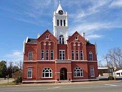 Schley County Courthouse in Ellaville | |
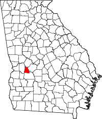 Location in the U.S. state of Georgia | |
 Georgia's location in the U.S. | |
| Founded | December 22, 1857 |
| Named for | William Schley |
| Seat | Ellaville |
| Largest city | Ellaville |
| Area | |
| • Total | 168 sq mi (435 km2) |
| • Land | 167 sq mi (433 km2) |
| • Water | 0.9 sq mi (2 km2), 0.5% |
| Population | |
| • (2010) | 5,010 |
| • Density | 30/sq mi (10/km2) |
| Congressional district | 2nd |
| Time zone | Eastern: UTC−5/−4 |
Schley County is a county located in the U.S. state of Georgia. (Schley is properly pronounced "sly", as this is the correct pronunciation of Gov. William Schley, for whom the county is named). As of the 2010 census, the county's population was 5,010.[1] The county seat is Ellaville.[2]
Schley County is part of the Americus, GA Micropolitan Statistical Area.
History
The County was created by an act of the Georgia General Assembly on December 22, 1857, and is named for William Schley, United States representative and thirty-sixth governor of Georgia.
The first county courthouse was built in 1858. The present Schley County Courthouse dates from 1899.[3]
Geography
According to the U.S. Census Bureau, the county has a total area of 168 square miles (440 km2), of which 167 square miles (430 km2) is land and 0.9 square miles (2.3 km2) (0.5%) is water.[4]
The central portion of Schley County, roughly north of Ellaville, is located in the Middle Flint River sub-basin of the ACF River Basin (Apalachicola-Chattahoochee-Flint River Basin). The very northern border area of the county is located in the Upper Flint River sub-basin of the same ACF River Basin. The southwestern portion of Schley County, southwest of Ellaville, is located in the Kinchafoonee-Muckalee sub-basin of the same larger ACF River Basin.[5]
Major highways
Adjacent counties
- Taylor County (north)
- Macon County (east)
- Sumter County (south)
- Marion County (west)
Demographics
| Historical population | |||
|---|---|---|---|
| Census | Pop. | %± | |
| 1860 | 4,633 | — | |
| 1870 | 5,129 | 10.7% | |
| 1880 | 5,302 | 3.4% | |
| 1890 | 5,443 | 2.7% | |
| 1900 | 5,499 | 1.0% | |
| 1910 | 5,213 | −5.2% | |
| 1920 | 5,243 | 0.6% | |
| 1930 | 5,347 | 2.0% | |
| 1940 | 5,033 | −5.9% | |
| 1950 | 4,036 | −19.8% | |
| 1960 | 3,256 | −19.3% | |
| 1970 | 3,097 | −4.9% | |
| 1980 | 3,433 | 10.8% | |
| 1990 | 3,588 | 4.5% | |
| 2000 | 3,766 | 5.0% | |
| 2010 | 5,010 | 33.0% | |
| Est. 2016 | 5,098 | [6] | 1.8% |
| U.S. Decennial Census[7] 1790-1960[8] 1900-1990[9] 1990-2000[10] 2010-2013[1] | |||
2000 census
As of the census[11] of 2000, there were 9,766 people, 1,435 households, and 1,041 families residing in the county. The population density was 22 people per square mile (9/km²). There were 1,612 housing units at an average density of 10 per square mile (4/km²). The racial makeup of the county was 61.28% White, 35.77% Black or African American, 0.21% Native American, 0.08% Asian, 0.16% Pacific Islander, 1.35% from other races, and 1.14% from two or more races. 2.36% of the population were Hispanic or Latino of any race.
There were 1,435 households out of which 36.30% had children under the age of 18 living with them, 52.10% were married couples living together, 15.70% had a female householder with no husband present, and 27.40% were non-families. 24.80% of all households were made up of individuals and 11.30% had someone living alone who was 65 years of age or older. The average household size was 2.62 and the average family size was 3.11.
In the county, the population was spread out with 29.30% under the age of 18, 8.20% from 18 to 24, 27.50% from 25 to 44, 24.00% from 45 to 64, and 11.10% who were 65 years of age or older. The median age was 34 years. For every 100 females, there were 91.80 males. For every 100 females age 18 and over, there were 88.70 males.
The median income for a household in the county was $32,035, and the median income for a family was $36,215. Males had a median income of $29,239 versus $19,952 for females. The per capita income for the county was $14,981. About 15.80% of families and 19.90% of the population were below the poverty line, including 26.00% of those under age 18 and 22.70% of those age 65 or over.
2010 census
As of the 2010 United States Census, there were 5,010 people, 1,872 households, and 1,334 families residing in the county.[12] The population density was 30.0 inhabitants per square mile (11.6/km2). There were 2,208 housing units at an average density of 13.2 per square mile (5.1/km2).[13] The racial makeup of the county was 73.0% white, 23.3% black or African American, 0.7% Asian, 1.9% from other races, and 1.0% from two or more races. Those of Hispanic or Latino origin made up 3.2% of the population.[12] In terms of ancestry, 14.1% were Irish, 8.5% were German, 8.1% were American, and 7.2% were English.[14]
Of the 1,872 households, 40.2% had children under the age of 18 living with them, 52.5% were married couples living together, 13.8% had a female householder with no husband present, 28.7% were non-families, and 25.6% of all households were made up of individuals. The average household size was 2.68 and the average family size was 3.24. The median age was 37.1 years.[12]
The median income for a household in the county was $35,096 and the median income for a family was $47,234. Males had a median income of $37,339 versus $30,761 for females. The per capita income for the county was $16,122. About 12.4% of families and 19.2% of the population were below the poverty line, including 20.8% of those under age 18 and 16.6% of those age 65 or over.[15]
Communities
City
Unincorporated communities
Politics
| Year | Republican | Democratic | Third parties |
|---|---|---|---|
| 2016 | 77.1% 1,472 | 21.0% 401 | 1.9% 36 |
| 2012 | 73.4% 1,286 | 25.6% 448 | 1.0% 18 |
| 2008 | 72.0% 1,252 | 27.5% 479 | 0.5% 8 |
| 2004 | 69.4% 1,063 | 30.3% 464 | 0.3% 5 |
| 2000 | 60.0% 706 | 39.1% 460 | 0.9% 10 |
| 1996 | 40.2% 470 | 49.2% 576 | 10.6% 124 |
| 1992 | 39.4% 511 | 46.4% 601 | 14.2% 184 |
| 1988 | 58.9% 635 | 40.7% 439 | 0.4% 4 |
| 1984 | 60.4% 614 | 39.6% 403 | |
| 1980 | 41.8% 453 | 56.5% 613 | 1.8% 19 |
| 1976 | 25.5% 268 | 74.5% 783 | |
| 1972 | 81.1% 694 | 18.9% 162 | |
| 1968 | 15.0% 164 | 28.3% 309 | 56.7% 619 |
| 1964 | 60.5% 577 | 39.5% 377 | |
| 1960 | 22.8% 138 | 77.2% 467 | |
| 1956 | 21.0% 117 | 79.0% 441 | |
| 1952 | 25.3% 148 | 74.7% 436 | |
| 1948 | 19.7% 74 | 68.5% 257 | 11.7% 44 |
| 1944 | 10.1% 37 | 89.9% 329 | |
| 1940 | 12.7% 69 | 86.9% 471 | 0.4% 2 |
| 1936 | 9.3% 43 | 90.7% 419 | |
| 1932 | 2.0% 8 | 97.6% 398 | 0.5% 2 |
| 1928 | 19.0% 77 | 81.0% 328 | |
| 1924 | 4.3% 12 | 94.7% 266 | 1.1% 3 |
| 1920 | 18.4% 53 | 81.6% 235 | |
| 1916 | 13.5% 35 | 85.7% 222 | 0.8% 2 |
| 1912 | 8.1% 19 | 90.6% 213 | 1.3% 3 |
See also
References
- 1 2 "State & County QuickFacts". United States Census Bureau. Retrieved June 26, 2014.
- ↑ "Find a County". National Association of Counties. Retrieved 2011-06-07.
- ↑ Hellmann, Paul T. (May 13, 2013). Historical Gazetteer of the United States. Routledge. p. 229. ISBN 1135948593. Retrieved 30 November 2013.
- ↑ "US Gazetteer files: 2010, 2000, and 1990". United States Census Bureau. 2011-02-12. Retrieved 2011-04-23.
- ↑ "Georgia Soil and Water Conservation Commission Interactive Mapping Experience". Georgia Soil and Water Conservation Commission. Retrieved 2015-11-22.
- ↑ "Population and Housing Unit Estimates". Retrieved June 9, 2017.
- ↑ "U.S. Decennial Census". United States Census Bureau. Retrieved June 26, 2014.
- ↑ "Historical Census Browser". University of Virginia Library. Retrieved June 26, 2014.
- ↑ "Population of Counties by Decennial Census: 1900 to 1990". United States Census Bureau. Retrieved June 26, 2014.
- ↑ "Census 2000 PHC-T-4. Ranking Tables for Counties: 1990 and 2000" (PDF). United States Census Bureau. Retrieved June 26, 2014.
- ↑ "American FactFinder". United States Census Bureau. Retrieved 2008-01-31.
- 1 2 3 "DP-1 Profile of General Population and Housing Characteristics: 2010 Demographic Profile Data". United States Census Bureau. Retrieved 2015-12-30.
- ↑ "Population, Housing Units, Area, and Density: 2010 - County". United States Census Bureau. Retrieved 2015-12-30.
- ↑ "DP02 SELECTED SOCIAL CHARACTERISTICS IN THE UNITED STATES – 2006-2010 American Community Survey 5-Year Estimates". United States Census Bureau. Retrieved 2015-12-30.
- ↑ "DP03 SELECTED ECONOMIC CHARACTERISTICS – 2006-2010 American Community Survey 5-Year Estimates". United States Census Bureau. Retrieved 2015-12-30.
- ↑ Leip, David. "Dave Leip's Atlas of U.S. Presidential Elections". uselectionatlas.org. Retrieved 2018-03-22.
Places adjacent to Schley County, Georgia | ||||||||||
|---|---|---|---|---|---|---|---|---|---|---|
| ||||||||||
Municipalities and communities of Schley County, Georgia, United States | ||
|---|---|---|
| City | | |
| Unincorporated communities | ||