Atkinson County, Georgia
| Atkinson County, Georgia | |
|---|---|
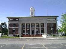 Atkinson County Courthouse in Pearson | |
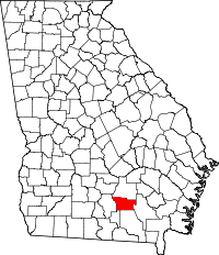 Location in the U.S. state of Georgia | |
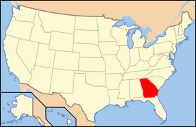 Georgia's location in the U.S. | |
| Founded | August 15, 1917 |
| Named for | William Yates Atkinson |
| Seat | Pearson |
| Largest city | Pearson |
| Area | |
| • Total | 345 sq mi (894 km2) |
| • Land | 339 sq mi (878 km2) |
| • Water | 5.2 sq mi (13 km2), 1.5% |
| Population | |
| • (2010) | 8,375 |
| • Density | 25/sq mi (10/km2) |
| Congressional district | 8th |
| Time zone | Eastern: UTC−5/−4 |
| Website |
www |
Atkinson County is a county located in the southeastern portion of the U.S. state of Georgia. As of the 2010 census, the population was 8,375.[1] The county seat is Pearson.[2] The county was formed in 1917 from parts of Coffee and Clinch Counties. It is named for William Yates Atkinson, Democratic governor of Georgia from 1894 to 1898.[3] In 2003 it had the highest illiteracy rate of any U.S. county at 36%.[4]
Geography
According to the U.S. Census Bureau, the county has a total area of 345 square miles (890 km2), of which 339 square miles (880 km2) is land and 5.2 square miles (13 km2) (1.5%) is water.[5]
The vast majority of Atkinson County is located in the Satilla River sub-basin of the St. Marys-Satilla River basin. The entire narrow western border area, in a line parallel to the western border and running through Willacoochee, is located in the Alapaha River sub-basin of the Suwannee River basin. A small southeastern corner of the county is located in the Upper Suwannee River sub-basin of the same Suwannee River basin.[6]
Major highways
Adjacent counties
- Coffee County - north
- Ware County - east
- Clinch County - south
- Lanier County - southwest
- Berrien County - west
Demographics
| Historical population | |||
|---|---|---|---|
| Census | Pop. | %± | |
| 1920 | 7,656 | — | |
| 1930 | 6,894 | −10.0% | |
| 1940 | 7,093 | 2.9% | |
| 1950 | 7,362 | 3.8% | |
| 1960 | 6,188 | −15.9% | |
| 1970 | 5,879 | −5.0% | |
| 1980 | 6,141 | 4.5% | |
| 1990 | 6,213 | 1.2% | |
| 2000 | 7,609 | 22.5% | |
| 2010 | 8,375 | 10.1% | |
| Est. 2016 | 8,273 | [7] | −1.2% |
| U.S. Decennial Census[8] 1790-1960[9] 1900-1990[10] 1990-2000[11] 2010-2013[1] | |||
2000 census
As of the census[12] of 2010, there were 8,375 people, 2,983 households, and 2,159 families residing in the county. The population density was 25 people per square mile (9/km²). There were 3,171 housing units at an average density of 9 per square mile (4/km²). The racial makeup of the county was 62.2% White, 17.3% Black or African American, 0.6% Native American, 0.3% Asian, 0.03% Pacific Islander, 17.7% from other races, and 1.6% from two or more races. 24.3% of the population were Hispanic or Latino of any race.
There were 2,983 households out of which 41.2% had children under the age of 18 living with them, 50.3% were married couples living together, 15.3% had a female householder with no husband present, and 27.6% were non-families. 22.9% of all households were made up of individuals living alone and 8.4% had someone living alone who was 65 years of age or older. The average household size was 2.8 and the average family size was 3.29.
The median income for a household in the county was $28,682.
2010 census
As of the 2010 United States Census, there were 8,375 people, 2,983 households, and 2,159 families residing in the county.[13] The population density was 24.7 inhabitants per square mile (9.5/km2). There were 3,522 housing units at an average density of 10.4 per square mile (4.0/km2).[14] The racial makeup of the county was 62.2% white, 17.3% black or African American, 0.6% American Indian, 0.3% Pacific islander, 0.3% Asian, 17.7% from other races, and 1.6% from two or more races. Those of Hispanic or Latino origin made up 24.3% of the population.[13] In terms of ancestry, 16.1% were English, 16.0% were Irish, and 7.5% were American.[15]
Of the 2,983 households, 41.2% had children under the age of 18 living with them, 50.3% were married couples living together, 15.3% had a female householder with no husband present, 27.6% were non-families, and 22.9% of all households were made up of individuals. The average household size was 2.80 and the average family size was 3.29. The median age was 33.4 years.[13]
The median income for a household in the county was $33,834 and the median income for a family was $34,859. Males had a median income of $29,286 versus $25,705 for females. The per capita income for the county was $15,456. About 19.8% of families and 28.0% of the population were below the poverty line, including 42.4% of those under age 18 and 21.3% of those age 65 or over.[16]
Education
The county is serviced along with Coffee County, Georgia by the Satilla Regional Library System.
Communities
Cities
Unincorporated communities
- Axson
- Guthrie Heights
- Henderson Still
- Kirkland
- Leliaton
- Oberry
- Sandy Bottom
- Morrisville
Politics
| Year | Republican | Democratic | Third parties |
|---|---|---|---|
| 2016 | 72.0% 1,878 | 26.7% 697 | 1.3% 35 |
| 2012 | 66.7% 1,938 | 32.0% 930 | 1.3% 39 |
| 2008 | 66.8% 1,941 | 32.3% 938 | 1.0% 28 |
| 2004 | 67.4% 1,666 | 32.3% 799 | 0.3% 8 |
| 2000 | 59.3% 1,228 | 39.6% 821 | 1.1% 22 |
| 1996 | 42.9% 784 | 45.1% 823 | 12.0% 219 |
| 1992 | 35.7% 779 | 48.3% 1,056 | 16.0% 350 |
| 1988 | 55.6% 1,126 | 43.8% 887 | 0.6% 12 |
| 1984 | 51.2% 944 | 48.8% 901 | |
| 1980 | 33.6% 747 | 65.2% 1,449 | 1.2% 26 |
| 1976 | 18.2% 347 | 81.8% 1,560 | |
| 1972 | 74.9% 924 | 25.1% 309 | |
| 1968 | 11.4% 288 | 27.1% 686 | 61.5% 1,554 |
| 1964 | 58.8% 1,157 | 41.2% 811 | 0.1% 1 |
| 1960 | 15.6% 239 | 84.5% 1,298 | |
| 1956 | 6.6% 122 | 93.4% 1,719 | |
| 1952 | 11.1% 194 | 88.9% 1,560 | |
| 1948 | 10.2% 114 | 83.8% 938 | 6.1% 68 |
| 1944 | 10.5% 90 | 89.5% 766 | |
| 1940 | 8.6% 66 | 91.3% 703 | 0.1% 1 |
| 1936 | 2.9% 29 | 97.1% 958 | |
| 1932 | 5.2% 41 | 94.2% 747 | 0.6% 5 |
| 1928 | 25.7% 121 | 74.3% 350 | |
| 1924 | 5.7% 25 | 90.4% 394 | 3.9% 17 |
| 1920 | 20.8% 119 | 79.2% 453 |
See also
References
- 1 2 "State & County QuickFacts". United States Census Bureau. Retrieved June 17, 2014.
- ↑ "Find a County". National Association of Counties. Archived from the original on 2011-05-31. Retrieved 2011-06-07.
- ↑ Krakow, Kenneth K. (1975). Georgia Place-Names: Their History and Origins (PDF). Macon, GA: Winship Press. p. 8. ISBN 0-915430-00-2.
- ↑ "State and County Literacy Estimates - State Estimates". nces.ed.gov. Retrieved 2018-03-18.
- ↑ "US Gazetteer files: 2010, 2000, and 1990". United States Census Bureau. 2011-02-12. Retrieved 2011-04-23.
- ↑ "Georgia Soil and Water Conservation Commission Interactive Mapping Experience". Georgia Soil and Water Conservation Commission. Retrieved 2015-11-27.
- ↑ "Population and Housing Unit Estimates". Retrieved June 9, 2017.
- ↑ "U.S. Decennial Census". United States Census Bureau. Archived from the original on May 12, 2015. Retrieved June 17, 2014.
- ↑ "Historical Census Browser". University of Virginia Library. Retrieved June 17, 2014.
- ↑ "Population of Counties by Decennial Census: 1900 to 1990". United States Census Bureau. Retrieved June 17, 2014.
- ↑ "Census 2000 PHC-T-4. Ranking Tables for Counties: 1990 and 2000" (PDF). United States Census Bureau. Retrieved June 17, 2014.
- ↑ "American FactFinder". United States Census Bureau. Archived from the original on 2013-09-11. Retrieved 2011-05-14.
- 1 2 3 "DP-1 Profile of General Population and Housing Characteristics: 2010 Demographic Profile Data". United States Census Bureau. Retrieved 2015-12-27.
- ↑ "Population, Housing Units, Area, and Density: 2010 - County". United States Census Bureau. Retrieved 2015-12-27.
- ↑ "DP02 SELECTED SOCIAL CHARACTERISTICS IN THE UNITED STATES – 2006-2010 American Community Survey 5-Year Estimates". United States Census Bureau. Retrieved 2015-12-27.
- ↑ "DP03 SELECTED ECONOMIC CHARACTERISTICS – 2006-2010 American Community Survey 5-Year Estimates". United States Census Bureau. Retrieved 2015-12-27.
- ↑ Leip, David. "Dave Leip's Atlas of U.S. Presidential Elections". uselectionatlas.org. Retrieved 2018-03-18.
External links
- list of places
- Atkinson County Sheriff's Office
- Atkinson County historical marker
Places adjacent to Atkinson County, Georgia | ||||||||||
|---|---|---|---|---|---|---|---|---|---|---|
| ||||||||||
Municipalities and communities of Atkinson County, Georgia, United States | ||
|---|---|---|
| Cities | | |
| Unincorporated community | ||