McDuffie County, Georgia
| McDuffie County, Georgia | |
|---|---|
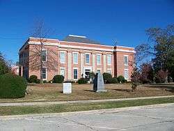 McDuffie County Courthouse in Thomson | |
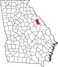 Location in the U.S. state of Georgia | |
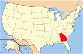 Georgia's location in the U.S. | |
| Founded | 1870 |
| Named for | George McDuffie |
| Seat | Thomson |
| Largest city | Thomson |
| Area | |
| • Total | 266 sq mi (689 km2) |
| • Land | 257 sq mi (666 km2) |
| • Water | 8.9 sq mi (23 km2), 3.4% |
| Population | |
| • (2010) | 21,875 |
| • Density | 85/sq mi (33/km2) |
| Congressional district | 10th |
| Time zone | Eastern: UTC−5/−4 |
| Website |
www |
McDuffie County is a county located in the U.S. state of Georgia. As of the 2010 census, the population was 21,875.[1] The county seat is Thomson.[2] The county was created on October 18, 1870[3] and named after the South Carolina governor and senator George McDuffie.[4]
McDuffie County is part of the Augusta-Richmond County, GA-SC Metropolitan Statistical Area.
History
Most communities located in the county were founded before the county was created. Some have faded into obscurity. The Historic Wrightsborough Foundation preserves the memory of the early settlement of Wrightborough, which was occupied 1768 to 1920.[5]
Geography
According to the U.S. Census Bureau, the county has a total area of 266 square miles (690 km2), of which 257 square miles (670 km2) is land and 8.9 square miles (23 km2) (3.4%) is water.[6]
Most of the southern half of McDuffie County, south of Thomson, is located in the Brier Creek sub-basin of the Savannah River basin, except for a slice of the eastern portion of the county, north of Dearing and along a north-south line running through Boneville, which is located in the Middle Savannah River sub-basin of the Savannah River basin. The northern half of McDuffie County, north of Thomson, is located in the Little River sub-basin of the same Savannah River basin.[7]
Major highways


Adjacent counties
- Lincoln County (northeast)
- Columbia County (east)
- Richmond County (southeast)
- Jefferson County (south)
- Warren County (west)
- Wilkes County (northwest)
Demographics
| Historical population | |||
|---|---|---|---|
| Census | Pop. | %± | |
| 1880 | 9,449 | — | |
| 1890 | 8,789 | −7.0% | |
| 1900 | 9,804 | 11.5% | |
| 1910 | 10,325 | 5.3% | |
| 1920 | 11,509 | 11.5% | |
| 1930 | 9,014 | −21.7% | |
| 1940 | 10,878 | 20.7% | |
| 1950 | 11,443 | 5.2% | |
| 1960 | 12,627 | 10.3% | |
| 1970 | 15,276 | 21.0% | |
| 1980 | 18,546 | 21.4% | |
| 1990 | 20,119 | 8.5% | |
| 2000 | 21,231 | 5.5% | |
| 2010 | 21,875 | 3.0% | |
| Est. 2016 | 21,490 | [8] | −1.8% |
| U.S. Decennial Census[9] 1790-1960[10] 1900-1990[11] 1990-2000[12] 2010-2013[1] | |||
2000 census
As of the census[13] of 2000, there were 21,231 people, 7,970 households, and 5,857 families residing in the county. The population density was 32/km² (82/mi²). There were 8,916 housing units at an average density of 13/km² (34/mi²). The racial makeup of the county was 60.78% White, 37.52% Black or African American, 0.89% Native American, 0.2% Asian, 0.03% Pacific Islander, 0.32% from other races, and 0.76% from two or more races. 1.34% of the population were Hispanic or Latino of any race.
There were 7,970 households out of which 36.30% had children under the age of 18 living with them, 49.70% were married couples living together, 19.20% had a female householder with no husband present, and 26.50% were non-families. 23.20% of all households were made up of individuals and 9.40% had someone living alone who was 65 years of age or older. The average household size was 2.62 and the average family size was 3.08.
In the county, the population was spread out with 27.90% under the age of 18, 8.60% from 18 to 24, 28.40% from 25 to 44, 23.20% from 45 to 64, and 11.90% who were 65 years of age or older. The median age was 35 years. For every 100 females, there were 89.40 males. For every 100 females age 18 and over, there were 84.50 males.
The median income for a household in the county was $31,920, and the median income for a family was $38,235. Males had a median income of $30,147 versus $20,499 for females. The per capita income for the county was $18,005. About 14.10% of families and 18.40% of the population were below the poverty line, including 26.00% of those under age 18 and 20.00% of those age 65 or over.
2010 census
As of the 2010 United States Census, there were 21,875 people, 8,289 households, and 5,964 families residing in the county.[14] The population density was 85.0 inhabitants per square mile (32.8/km2). There were 9,319 housing units at an average density of 36.2 per square mile (14.0/km2).[15] The racial makeup of the county was 57.2% white, 39.8% black or African American, 0.3% Asian, 0.3% American Indian, 0.1% Pacific islander, 0.9% from other races, and 1.4% from two or more races. Those of Hispanic or Latino origin made up 2.2% of the population.[14] In terms of ancestry, 18.4% were American, 8.3% were English, 6.0% were Irish, and 5.4% were German.[16]
Of the 8,289 households, 36.7% had children under the age of 18 living with them, 45.0% were married couples living together, 21.4% had a female householder with no husband present, 28.0% were non-families, and 24.2% of all households were made up of individuals. The average household size was 2.60 and the average family size was 3.07. The median age was 38.4 years.[14]
The median income for a household in the county was $35,414 and the median income for a family was $42,472. Males had a median income of $34,300 versus $22,710 for females. The per capita income for the county was $17,261. About 16.0% of families and 19.5% of the population were below the poverty line, including 27.2% of those under age 18 and 20.1% of those age 65 or over.[17]
Education
Communities
Politics
| Year | Republican | Democratic | Third parties |
|---|---|---|---|
| 2016 | 58.6% 5,432 | 39.9% 3,699 | 1.5% 137 |
| 2012 | 57.0% 5,475 | 42.1% 4,044 | 0.9% 86 |
| 2008 | 57.1% 5,400 | 42.2% 3,989 | 0.7% 66 |
| 2004 | 62.3% 4,846 | 37.3% 2,899 | 0.5% 35 |
| 2000 | 59.9% 3,926 | 39.4% 2,580 | 0.7% 44 |
| 1996 | 51.0% 3,254 | 42.7% 2,725 | 6.4% 406 |
| 1992 | 45.7% 2,955 | 40.8% 2,640 | 13.5% 873 |
| 1988 | 65.0% 3,231 | 34.3% 1,704 | 0.7% 33 |
| 1984 | 62.1% 3,284 | 37.9% 2,006 | |
| 1980 | 41.2% 1,928 | 57.0% 2,667 | 1.9% 88 |
| 1976 | 35.9% 1,694 | 64.1% 3,024 | |
| 1972 | 75.0% 2,990 | 25.0% 996 | |
| 1968 | 32.9% 1,324 | 24.6% 992 | 42.5% 1,709 |
| 1964 | 70.3% 2,657 | 29.7% 1,124 | |
| 1960 | 49.1% 1,039 | 50.9% 1,079 | |
| 1956 | 38.5% 649 | 61.6% 1,039 | |
| 1952 | 44.3% 933 | 55.7% 1,172 | |
| 1948 | 84.0% 1,260 | 12.1% 182 | 3.9% 58 |
| 1944 | 19.0% 187 | 81.0% 795 | |
| 1940 | 7.2% 75 | 92.1% 959 | 0.7% 7 |
| 1936 | 12.1% 98 | 87.1% 705 | 0.7% 6 |
| 1932 | 4.8% 29 | 94.0% 568 | 1.2% 7 |
| 1928 | 55.6% 381 | 44.4% 304 | |
| 1924 | 6.6% 37 | 47.7% 267 | 45.7% 256 |
| 1920 | 22.2% 109 | 77.8% 382 | |
| 1916 | 10.8% 65 | 77.5% 466 | 11.7% 70 |
| 1912 | 27.5% 106 | 70.2% 271 | 2.3% 9 |
See also
References
- 1 2 "State & County QuickFacts". United States Census Bureau. Archived from the original on July 14, 2011. Retrieved February 16, 2014.
- ↑ "Find a County". National Association of Counties. Archived from the original on May 31, 2011. Retrieved 2011-06-07.
- ↑ Georgia.gov's McDuffie County Overview
- ↑ Gannett, Henry (1905). The Origin of Certain Place Names in the United States. U.S. Government Printing Office. p. 194.
- ↑ Georgia Encyclopedia: Wrightsborough, accessed October 2017.
- ↑ "US Gazetteer files: 2010, 2000, and 1990". United States Census Bureau. 2011-02-12. Retrieved 2011-04-23.
- ↑ "Georgia Soil and Water Conservation Commission Interactive Mapping Experience". Georgia Soil and Water Conservation Commission. Retrieved 2015-11-19.
- ↑ "Population and Housing Unit Estimates". Retrieved June 9, 2017.
- ↑ "U.S. Decennial Census". United States Census Bureau. Archived from the original on May 12, 2015. Retrieved June 24, 2014.
- ↑ "Historical Census Browser". University of Virginia Library. Retrieved June 24, 2014.
- ↑ "Population of Counties by Decennial Census: 1900 to 1990". United States Census Bureau. Retrieved June 24, 2014.
- ↑ "Census 2000 PHC-T-4. Ranking Tables for Counties: 1990 and 2000" (PDF). United States Census Bureau. Retrieved June 24, 2014.
- ↑ "American FactFinder". United States Census Bureau. Archived from the original on September 11, 2013. Retrieved 2011-05-14.
- 1 2 3 "DP-1 Profile of General Population and Housing Characteristics: 2010 Demographic Profile Data". United States Census Bureau. Retrieved 2015-12-30.
- ↑ "Population, Housing Units, Area, and Density: 2010 - County". United States Census Bureau. Retrieved 2015-12-30.
- ↑ "DP02 SELECTED SOCIAL CHARACTERISTICS IN THE UNITED STATES – 2006-2010 American Community Survey 5-Year Estimates". United States Census Bureau. Retrieved 2015-12-30.
- ↑ "DP03 SELECTED ECONOMIC CHARACTERISTICS – 2006-2010 American Community Survey 5-Year Estimates". United States Census Bureau. Retrieved 2015-12-30.
- ↑ Leip, David. "Dave Leip's Atlas of U.S. Presidential Elections". uselectionatlas.org. Retrieved 2018-03-22.
External links
Places adjacent to McDuffie County, Georgia | ||||||||||
|---|---|---|---|---|---|---|---|---|---|---|
| ||||||||||
Municipalities and communities of McDuffie County, Georgia, United States | ||
|---|---|---|
| City | | |
| Town | ||
| Unincorporated communities | ||