Walker County, Georgia
| Walker County, Georgia | |
|---|---|
_Courthouse.jpg) Walker County Courthouse in LaFayette | |
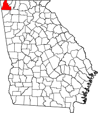 Location in the U.S. state of Georgia | |
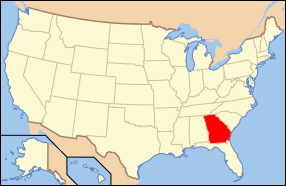 Georgia's location in the U.S. | |
| Founded | December 18, 1833 |
| Seat | LaFayette |
| Largest city | LaFayette |
| Area | |
| • Total | 447 sq mi (1,158 km2) |
| • Land | 446 sq mi (1,155 km2) |
| • Water | 0.6 sq mi (2 km2), 0.1% |
| Population | |
| • (2010) | 68,756 |
| • Density | 154/sq mi (59/km2) |
| Congressional district | 14th |
| Time zone | Eastern: UTC−5/−4 |
| Website |
www |
Walker County is a county located in the northwestern part of the U.S. state of Georgia. As of the 2010 census, the population was 68,756.[1] The county seat is LaFayette.[2] The county was created on December 18, 1833, from land formerly belonging to the Cherokee Indian Nation.
Walker County is part of the Chattanooga TN/GA Metropolitan Statistical Area.
Walker County is one of only nine counties in the United States still employing the sole commissioner form of government.
History
Walker County was named after Georgia'a U.S. Senator, Freeman Walker (1780-1827).[3]
Civil War battles fought in Walker County were part of the Chickamauga Campaign fought between August 21 and September 20, 1863:
- Second Battle of Chattanooga, August 21.
- Battle of Davis's Cross Roads, September 10–11.
- Battle of Chickamauga, September 19–20.
Geography
According to the U.S. Census Bureau, the county has a total area of 447 square miles (1,160 km2), of which 446 square miles (1,160 km2) is land and 0.6 square miles (1.6 km2) (0.1%) is water.[4] The northern two-thirds of Walker County is located in the Middle Tennessee-Chickamauga sub-basin of the Middle Tennessee-Hiwassee basin. Most of the southeastern portion of the county is located in the Oostanaula River sub-basin in the ACT River Basin (Coosa-Tallapoosa River Basin), with a very small southeastern sliver located in the Conasauga River sub-basin in the larger ACT River Basin. The rest of the southern portion of Walker County is located in the Upper Coosa River sub-basin in the ACT River Basin.[5]
Adjacent counties
- Hamilton County, Tennessee - north
- Catoosa County - northeast
- Whitfield County - east
- Gordon County - southeast
- Floyd County - south
- Chattooga County - south
- DeKalb County, Alabama - southwest/CST Border
- Dade County - west
Natural attractions and features
- Chattahoochee National Forest (part)
- Chickamauga and Chattanooga National Military Park (part)
- Ellison's Cave (12th deepest cave in the United States)
- Lookout Mountain (part)
- McLemore Cove
- Petty John's Cave
- Pigeon Mountain
- Rocktown
- Rock City
Transportation
Major highways
Railroads
Current
- Chattooga and Chickamauga Railway
- Tennessee Valley Railroad Museum (occasional tourist excursions)
Defunct
- Chattanooga Southern Railway (became Tennessee, Alabama and Georgia Railway)
- Tennessee, Alabama and Georgia Railway (purchased by Norfolk Southern then abandoned)
- Chickamauga and Durham Railroad (reorganized as Chattanooga & Durham)
- Chattanooga and Durham Railroad (purchased by Chattanooga, Rome and Southern)
- Chattanooga, Rome and Southern Railroad (purchased by Central of GA Railway)
- Central of Georgia Railway (purchased by Southern Railway)
- Southern Railway (purchased by Norfolk Southern, Walker County line transferred to State of Georgia, leased to Chattooga and Chickamauga Railway)
Demographics
| Historical population | |||
|---|---|---|---|
| Census | Pop. | %± | |
| 1840 | 6,572 | — | |
| 1850 | 13,109 | 99.5% | |
| 1860 | 10,082 | −23.1% | |
| 1870 | 9,925 | −1.6% | |
| 1880 | 11,056 | 11.4% | |
| 1890 | 13,282 | 20.1% | |
| 1900 | 15,661 | 17.9% | |
| 1910 | 18,692 | 19.4% | |
| 1920 | 23,370 | 25.0% | |
| 1930 | 26,206 | 12.1% | |
| 1940 | 31,024 | 18.4% | |
| 1950 | 38,198 | 23.1% | |
| 1960 | 45,264 | 18.5% | |
| 1970 | 50,691 | 12.0% | |
| 1980 | 56,470 | 11.4% | |
| 1990 | 58,340 | 3.3% | |
| 2000 | 61,053 | 4.7% | |
| 2010 | 68,756 | 12.6% | |
| Est. 2016 | 67,896 | [6] | −1.3% |
| U.S. Decennial Census[7] 1790-1960[8] 1900-1990[9] 1990-2000[10] 2010-2013[1] | |||
2000 census
As of the census[11] of 2000, there were 61,053 people, 23,605 households, and 17,467 families residing in the county. The population density was 137 people per square mile (53/km²). There were 25,577 housing units at an average density of 57 per square mile (22/km²). The racial makeup of the county was 94.43% White, 3.78% Black or African American, 0.29% Native American, 0.28% Asian, 0.02% Pacific Islander, 0.36% from other races, and 0.84% from two or more races. 0.93% of the population were Hispanic or Latino of any race.
There were 23,605 households out of which 32.60% had children under the age of 18 living with them, 57.80% were married couples living together, 12.00% had a female householder with no husband present, and 26.00% were non-families. 22.90% of all households were made up of individuals and 10.40% had someone living alone who was 65 years of age or older. The average household size was 2.54 and the average family size was 2.98.
In the county, the population was spread out with 24.80% under the age of 18, 8.70% from 18 to 24, 28.80% from 25 to 44, 23.90% from 45 to 64, and 13.80% who were 65 years of age or older. The median age was 37 years. For every 100 females, there were 94.40 males. For every 100 females age 18 and over, there were 90.90 males.
The median income for a household in the county was $32,406, and the median income for a family was $39,034. Males had a median income of $29,448 versus $21,583 for females. The per capita income for the county was $15,867. About 10.00% of families and 12.50% of the population were below the poverty line, including 17.10% of those under age 18 and 11.70% of those age 65 or over.
2010 census
As of the 2010 United States Census, there were 68,756 people, 26,497 households, and 18,898 families residing in the county.[12] The population density was 154.0 inhabitants per square mile (59.5/km2). There were 30,100 housing units at an average density of 67.4 per square mile (26.0/km2).[13] The racial makeup of the county was 93.0% white, 4.1% black or African American, 0.4% Asian, 0.3% American Indian, 0.6% from other races, and 1.6% from two or more races. Those of Hispanic or Latino origin made up 1.6% of the population.[12] In terms of ancestry, 25.9% were American, 15.3% were Irish, 11.2% were English, and 9.3% were German.[14]
Of the 26,497 households, 33.8% had children under the age of 18 living with them, 53.1% were married couples living together, 13.1% had a female householder with no husband present, 28.7% were non-families, and 24.7% of all households were made up of individuals. The average household size was 2.54 and the average family size was 3.01. The median age was 39.7 years.[12]
The median income for a household in the county was $38,723 and the median income for a family was $46,307. Males had a median income of $38,297 versus $29,285 for females. The per capita income for the county was $19,440. About 11.6% of families and 15.1% of the population were below the poverty line, including 20.0% of those under age 18 and 8.1% of those age 65 or over.[15]
Communities
Cities
Census-designated places
Unincorporated communities
- Dry Creek
- Flintstone
- High Point
- Kensington
- Naomi
- Noble
- Rock Spring
- Villanow
Politics
| Year | Republican | Democratic | Third parties |
|---|---|---|---|
| 2016 | 79.1% 18,950 | 17.6% 4,215 | 3.3% 791 |
| 2012 | 73.9% 16,247 | 24.0% 5,274 | 2.2% 475 |
| 2008 | 72.3% 17,110 | 25.8% 6,095 | 1.9% 449 |
| 2004 | 71.3% 15,340 | 27.8% 5,986 | 0.8% 176 |
| 2000 | 65.2% 12,326 | 33.6% 6,341 | 1.2% 228 |
| 1996 | 50.1% 8,817 | 38.3% 6,743 | 11.6% 2038 |
| 1992 | 48.5% 8,489 | 35.6% 6,217 | 15.9% 2782 |
| 1988 | 68.6% 10,487 | 31.1% 4,753 | 0.3% 40 |
| 1984 | 68.2% 10,734 | 31.8% 5,000 | |
| 1980 | 50.2% 7,088 | 48.2% 6,809 | 1.7% 235 |
| 1976 | 37.5% 4,807 | 62.5% 8,007 | |
| 1972 | 84.7% 8,728 | 15.3% 1,574 | |
| 1968 | 25.6% 3,664 | 13.5% 1,930 | 60.9% 8,725 |
| 1964 | 52.1% 5,939 | 47.8% 5,454 | 0.1% 8 |
| 1960 | 46.9% 4,027 | 53.1% 4,566 | |
| 1956 | 49.0% 3,552 | 51.0% 3,693 | |
| 1952 | 39.6% 2,866 | 60.4% 4,366 | |
| 1948 | 9.7% 477 | 69.8% 3,418 | 20.4% 1000 |
| 1944 | 21.7% 765 | 78.2% 2,753 | 0.0% 1 |
| 1940 | 16.3% 558 | 83.5% 2,859 | 0.2% 7 |
| 1936 | 16.5% 458 | 83.3% 2,313 | 0.2% 5 |
| 1932 | 15.1% 405 | 83.8% 2,255 | 1.2% 31 |
| 1928 | 62.9% 1,786 | 37.1% 1,053 | |
| 1924 | 32.9% 878 | 65.1% 1,740 | 2.0% 54 |
| 1920 | 44.3% 1,069 | 55.8% 1,347 | |
| 1916 | 11.4% 300 | 71.8% 1,883 | 16.7% 439 |
| 1912 | 29.1% 404 | 55.5% 771 | 15.5% 215 |
See also
References
- 1 2 "State & County QuickFacts". United States Census Bureau. Retrieved June 27, 2014.
- ↑ "Find a County". National Association of Counties. Retrieved 2011-06-07.
- ↑ "Walker County". Calhoun Times. 1 September 2004. p. 106. Retrieved 26 April 2015.
- ↑ "US Gazetteer files: 2010, 2000, and 1990". United States Census Bureau. 2011-02-12. Retrieved 2011-04-23.
- ↑ "Georgia Soil and Water Conservation Commission Interactive Mapping Experience". Georgia Soil and Water Conservation Commission. Retrieved 2015-11-19.
- ↑ "Population and Housing Unit Estimates". Retrieved June 9, 2017.
- ↑ "U.S. Decennial Census". United States Census Bureau. Retrieved June 27, 2014.
- ↑ "Historical Census Browser". University of Virginia Library. Retrieved June 27, 2014.
- ↑ "Population of Counties by Decennial Census: 1900 to 1990". United States Census Bureau. Retrieved June 27, 2014.
- ↑ "Census 2000 PHC-T-4. Ranking Tables for Counties: 1990 and 2000" (PDF). United States Census Bureau. Retrieved June 27, 2014.
- ↑ "American FactFinder". United States Census Bureau. Retrieved 2008-01-31.
- 1 2 3 "DP-1 Profile of General Population and Housing Characteristics: 2010 Demographic Profile Data". United States Census Bureau. Retrieved 2015-12-30.
- ↑ "Population, Housing Units, Area, and Density: 2010 - County". United States Census Bureau. Retrieved 2015-12-30.
- ↑ "DP02 SELECTED SOCIAL CHARACTERISTICS IN THE UNITED STATES – 2006-2010 American Community Survey 5-Year Estimates". United States Census Bureau. Retrieved 2015-12-30.
- ↑ "DP03 SELECTED ECONOMIC CHARACTERISTICS – 2006-2010 American Community Survey 5-Year Estimates". United States Census Bureau. Retrieved 2015-12-30.
- ↑ Leip, David. "Dave Leip's Atlas of U.S. Presidential Elections". uselectionatlas.org. Retrieved 2018-03-22.
External links
- City of Chickamauga
- City of LaFayette
- City of Rossville
- City of Lookout Mountain, Ga.
- Walker County Messenger
- WQCH Radio
- Walker County, GA, genealogy
Places adjacent to Walker County, Georgia | |
|---|---|
Municipalities and communities of Walker County, Georgia, United States | ||
|---|---|---|
| Cities | | |
| CDPs | ||
| Unincorporated communities | ||
| Ghost town | ||
| Footnotes | ‡This populated place also has portions in an adjacent county or counties | |