Stephens County, Georgia
| Stephens County, Georgia | |
|---|---|
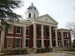 Stephens County Courthouse in Toccoa | |
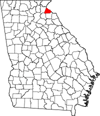 Location in the U.S. state of Georgia | |
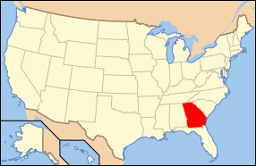 Georgia's location in the U.S. | |
| Founded | August 18, 1905 |
| Named for | Alexander Stephens |
| Seat | Toccoa |
| Largest city | Toccoa |
| Area | |
| • Total | 184 sq mi (477 km2) |
| • Land | 179 sq mi (464 km2) |
| • Water | 5.1 sq mi (13 km2), 2.8% |
| Population | |
| • (2010) | 26,175 |
| • Density | 146/sq mi (56/km2) |
| Congressional district | 9th |
| Time zone | Eastern: UTC−5/−4 |
Stephens County is a county located in the U.S. state of Georgia. As of the 2010 census, the population was 26,175.[1] The county seat is Toccoa.[2]
Stephens County comprises the Toccoa, GA Micropolitan Statistical Area.
History
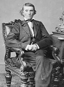
Originally inhabited by Mississippi Indian mound builders and then by Cherokee Indians, the first non-Indians in the area were Revolutionary War veterans who migrated up the Savannah River and the Tugaloo River after the war. Created on August 18, 1905 from parts of Franklin County and Habersham County, the county is named for Alexander Stephens, U.S. representative, Vice President of the Confederate States of America, and fifty-third governor of Georgia.
Two courthouses have served Stephens County. The first courthouse was built in 1908, and is now on the National Register of Historic Places. The second was built in 2000.[3]
On November 6, 1977, the Kelly Barnes Dam collapsed after a period of heavy rainfall, and the resulting flood killed 39 people and caused $2.8 million in damage.[4][5]
Geography
According to the U.S. Census Bureau, the county has a total area of 184 square miles (480 km2), of which 179 square miles (460 km2) is land and 5.1 square miles (13 km2) (2.8%) is water.[6]
The northern half of Stephens County is located in the Tugaloo River sub-basin of the Savannah River basin, while the southern half of the county is located in the Broad River sub-basin of the same Savannah River basin.[7]
Major highways
Adjacent counties
- Oconee County, South Carolina (north)
- Franklin County (south)
- Banks County (southwest)
- Habersham County (west)
National protected area
Demographics
| Historical population | |||
|---|---|---|---|
| Census | Pop. | %± | |
| 1910 | 9,728 | — | |
| 1920 | 11,215 | 15.3% | |
| 1930 | 11,740 | 4.7% | |
| 1940 | 12,972 | 10.5% | |
| 1950 | 16,647 | 28.3% | |
| 1960 | 18,391 | 10.5% | |
| 1970 | 20,331 | 10.5% | |
| 1980 | 21,763 | 7.0% | |
| 1990 | 23,257 | 6.9% | |
| 2000 | 25,435 | 9.4% | |
| 2010 | 26,175 | 2.9% | |
| Est. 2016 | 25,751 | [8] | −1.6% |
| U.S. Decennial Census[9] 1790-1960[10] 1900-1990[11] 1990-2000[12] 2010-2013[1] | |||
As of the 2010 United States Census, there were 26,175 people, 10,289 households, and 7,236 families residing in the county.[13] The population density was 146.1 inhabitants per square mile (56.4/km2). There were 12,662 housing units at an average density of 70.7 per square mile (27.3/km2).[14] The racial makeup of the county was 85.1% white, 10.9% black or African American, 0.7% Asian, 0.3% American Indian, 0.1% Pacific islander, 1.0% from other races, and 2.0% from two or more races. Those of Hispanic or Latino origin made up 2.4% of the population.[13] In terms of ancestry, 14.7% were American, 9.1% were Irish, 8.1% were German, and 7.4% were English.[15]
Of the 10,289 households, 31.5% had children under the age of 18 living with them, 52.8% were married couples living together, 13.2% had a female householder with no husband present, 29.7% were non-families, and 25.7% of all households were made up of individuals. The average household size was 2.49 and the average family size was 2.96. The median age was 40.7 years.[13]
The median income for a household in the county was $34,938 and the median income for a family was $41,768. Males had a median income of $35,814 versus $24,834 for females. The per capita income for the county was $18,285. About 12.3% of families and 18.8% of the population were below the poverty line, including 25.9% of those under age 18 and 16.0% of those age 65 or over.[16]
Communities
Politics
| Year | Republican | Democratic | Third parties |
|---|---|---|---|
| 2016 | 78.3% 7,686 | 18.7% 1,837 | 3.0% 292 |
| 2012 | 75.7% 7,221 | 22.4% 2,131 | 1.9% 182 |
| 2008 | 72.9% 7,689 | 25.6% 2,705 | 1.5% 158 |
| 2004 | 71.4% 6,904 | 28.1% 2,714 | 0.6% 56 |
| 2000 | 64.1% 5,370 | 34.3% 2,869 | 1.6% 137 |
| 1996 | 48.8% 3,890 | 38.5% 3,072 | 12.7% 1015 |
| 1992 | 47.7% 4,047 | 35.0% 2,976 | 17.3% 1470 |
| 1988 | 66.1% 4,329 | 33.4% 2,185 | 0.6% 36 |
| 1984 | 64.1% 4,057 | 35.9% 2,272 | |
| 1980 | 30.6% 2,045 | 67.7% 4,529 | 1.8% 118 |
| 1976 | 19.4% 1,340 | 80.6% 5,560 | |
| 1972 | 81.2% 3,773 | 18.8% 871 | |
| 1968 | 25.2% 1,295 | 20.2% 1035 | 54.6% 2,802 |
| 1964 | 28.2% 1,371 | 71.8% 3,483 | |
| 1960 | 20.9% 815 | 79.1% 3,087 | |
| 1956 | 20.9% 684 | 79.1% 2,595 | |
| 1952 | 15.7% 661 | 84.3% 3,539 | |
| 1948 | 9.8% 130 | 68.9% 912 | 21.2% 281 |
| 1944 | 15.5% 212 | 84.5% 1,158 | |
| 1940 | 7.6% 90 | 91.7% 1,084 | 0.7% 8 |
| 1936 | 5.6% 68 | 94.2% 1,142 | 0.2% 2 |
| 1932 | 1.7% 18 | 97.5% 1,026 | 0.8% 8 |
| 1928 | 38.1% 270 | 61.9% 438 | |
| 1924 | 6.7% 40 | 87.3% 523 | 6.0% 36 |
| 1920 | 37.8% 252 | 62.2% 415 | |
| 1916 | 10.4% 60 | 87.0% 500 | 2.6% 15 |
| 1912 | 12.0% 57 | 85.1% 405 | 2.9% 14 |
Further reading
- Cooksey, Elizabeth B. "Stephens County." New Georgia Encyclopedia. 14 October 2014. Web. 18 May 2016.
See also
References
- 1 2 "State & County QuickFacts". United States Census Bureau. Retrieved February 18, 2014.
- ↑ "Find a County". National Association of Counties. Retrieved 2011-06-07.
- ↑ Hellmann, Paul T. (May 13, 2013). Historical Gazetteer of the United States. Routledge. p. 250. Retrieved 30 November 2013.
- ↑ "TFC Remembers the Flood | Toccoa Falls College". 2016-01-08. Archived from the original on 2016-01-08. Retrieved 2018-03-22.
- ↑ USGS, Brian McCallum,. "USGS South Atlantic Water Science Center - The 1977 Toccoa Flood, Report of Failure of Kelly Barnes Dam Flood and Findings". www2.usgs.gov. Retrieved 2018-03-22.
- ↑ "US Gazetteer files: 2010, 2000, and 1990". United States Census Bureau. 2011-02-12. Retrieved 2011-04-23.
- ↑ "Georgia Soil and Water Conservation Commission Interactive Mapping Experience". Georgia Soil and Water Conservation Commission. Retrieved 2015-11-18.
- ↑ "Population and Housing Unit Estimates". Retrieved June 9, 2017.
- ↑ "U.S. Decennial Census". United States Census Bureau. Retrieved June 26, 2014.
- ↑ "Historical Census Browser". University of Virginia Library. Retrieved June 26, 2014.
- ↑ "Population of Counties by Decennial Census: 1900 to 1990". United States Census Bureau. Retrieved June 26, 2014.
- ↑ "Census 2000 PHC-T-4. Ranking Tables for Counties: 1990 and 2000" (PDF). United States Census Bureau. Retrieved June 26, 2014.
- 1 2 3 "DP-1 Profile of General Population and Housing Characteristics: 2010 Demographic Profile Data". United States Census Bureau. Retrieved 2015-12-30.
- ↑ "Population, Housing Units, Area, and Density: 2010 - County". United States Census Bureau. Retrieved 2015-12-30.
- ↑ "DP02 SELECTED SOCIAL CHARACTERISTICS IN THE UNITED STATES – 2006-2010 American Community Survey 5-Year Estimates". United States Census Bureau. Retrieved 2015-12-30.
- ↑ "DP03 SELECTED ECONOMIC CHARACTERISTICS – 2006-2010 American Community Survey 5-Year Estimates". United States Census Bureau. Retrieved 2015-12-30.
- ↑ Leip, David. "Dave Leip's Atlas of U.S. Presidential Elections". uselectionatlas.org. Retrieved 2018-03-22.
External links
| Wikimedia Commons has media related to Stephens County, Georgia. |
- Official Stephens County website
- Stephens County Development Authority
- Toccoa-Stephens County Chamber of Commerce
- Things to do in Stephens County
- Stephens County history
- Toccoa-Stephens County community website
Places adjacent to Stephens County, Georgia | ||||||||||
|---|---|---|---|---|---|---|---|---|---|---|
| ||||||||||
Municipalities and communities of Stephens County, Georgia, United States | ||
|---|---|---|
| City | | |
| Towns | ||
| Unincorporated communities | ||
| Footnotes | ‡This populated place also has portions in an adjacent county or counties | |