Sant'Antonino, Haute-Corse
| Sant'Antonino | |
|---|---|
| Commune | |
 Sant'Antonino, and the villages of the Balagne | |
 Sant'Antonino Location within Corsica region  Sant'Antonino | |
| Coordinates: 42°35′24″N 8°54′20″E / 42.59°N 8.9056°ECoordinates: 42°35′24″N 8°54′20″E / 42.59°N 8.9056°E | |
| Country | France |
| Region | Corsica |
| Department | Haute-Corse |
| Arrondissement | Calvi |
| Canton | Calvi |
| Intercommunality | Calvi Balagne |
| Government | |
| • Mayor (2001–2008) | Étienne Marcelli |
| Area1 | 4.1 km2 (1.6 sq mi) |
| Population (2008)2 | 93 |
| • Density | 23/km2 (59/sq mi) |
| Time zone | UTC+1 (CET) |
| • Summer (DST) | UTC+2 (CEST) |
| INSEE/Postal code | 2B296 /20220 |
| Elevation |
138–521 m (453–1,709 ft) (avg. 497 m or 1,631 ft) |
|
1 French Land Register data, which excludes lakes, ponds, glaciers > 1 km2 (0.386 sq mi or 247 acres) and river estuaries. 2 Population without double counting: residents of multiple communes (e.g., students and military personnel) only counted once. | |
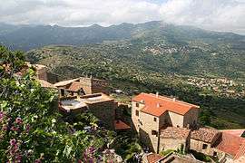
Sant'Antonino (French pronunciation: [sɑ̃.t‿ɑ̃tɔnino]) is a commune in the Haute-Corse department of France on the island of Corsica. It is one of Les Plus Beaux Villages de France.
Population
| Historical population | ||
|---|---|---|
| Year | Pop. | ±% |
| 1962 | 109 | — |
| 1968 | 121 | +11.0% |
| 1975 | 113 | −6.6% |
| 1982 | 79 | −30.1% |
| 1990 | 60 | −24.1% |
| 1999 | 77 | +28.3% |
| 2008 | 93 | +20.8% |
See also
References
| Wikimedia Commons has media related to Sant'Antonino (Haute-Corse). |
This article is issued from
Wikipedia.
The text is licensed under Creative Commons - Attribution - Sharealike.
Additional terms may apply for the media files.