Meria
| Meria | |
|---|---|
| Commune | |
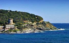 The Genoese tower in Meria | |
 Meria Location within Corsica region  Meria | |
| Coordinates: 42°55′40″N 9°27′12″E / 42.9278°N 9.4533°ECoordinates: 42°55′40″N 9°27′12″E / 42.9278°N 9.4533°E | |
| Country | France |
| Region | Corsica |
| Department | Haute-Corse |
| Arrondissement | Bastia |
| Canton | Cap Corse |
| Intercommunality | Cap Corse |
| Government | |
| • Mayor (2008–2014) | Laurent Napoléon Piazza |
| Area1 | 20.43 km2 (7.89 sq mi) |
| Population (2008)2 | 97 |
| • Density | 4.7/km2 (12/sq mi) |
| Time zone | UTC+1 (CET) |
| • Summer (DST) | UTC+2 (CEST) |
| INSEE/Postal code | 2B159 /20287 |
| Elevation |
0–604 m (0–1,982 ft) (avg. 200 m or 660 ft) |
|
1 French Land Register data, which excludes lakes, ponds, glaciers > 1 km2 (0.386 sq mi or 247 acres) and river estuaries. 2 Population without double counting: residents of multiple communes (e.g., students and military personnel) only counted once. | |
Meria is a commune in the Haute-Corse department of France on the island of Corsica.
Population
| Historical population | ||
|---|---|---|
| Year | Pop. | ±% |
| 1962 | 107 | — |
| 1968 | 108 | +0.9% |
| 1975 | 111 | +2.8% |
| 1982 | 79 | −28.8% |
| 1990 | 76 | −3.8% |
| 1999 | 85 | +11.8% |
| 2008 | 97 | +14.1% |
See also
References
| Wikimedia Commons has media related to Meria. |
This article is issued from
Wikipedia.
The text is licensed under Creative Commons - Attribution - Sharealike.
Additional terms may apply for the media files.