Monticello, Haute-Corse
| Monticello | |
|---|---|
| Commune | |
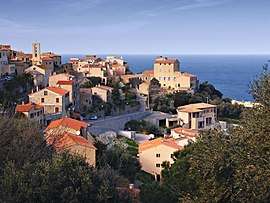 The village of Monticello | |
 Monticello Location within Corsica region  Monticello | |
| Coordinates: 42°37′05″N 8°57′16″E / 42.6181°N 8.9544°ECoordinates: 42°37′05″N 8°57′16″E / 42.6181°N 8.9544°E | |
| Country | France |
| Region | Corsica |
| Department | Haute-Corse |
| Arrondissement | Calvi |
| Canton | L'Île-Rousse |
| Intercommunality | Bassin de vie de l'Île-Rousse |
| Government | |
| • Mayor (2008–2014) | Hyacinthe Mattei |
| Area1 | 10.64 km2 (4.11 sq mi) |
| Population (2008)2 | 1,708 |
| • Density | 160/km2 (420/sq mi) |
| Time zone | UTC+1 (CET) |
| • Summer (DST) | UTC+2 (CEST) |
| INSEE/Postal code | 2B168 /20220 |
| Elevation |
0–408 m (0–1,339 ft) (avg. 120 m or 390 ft) |
|
1 French Land Register data, which excludes lakes, ponds, glaciers > 1 km2 (0.386 sq mi or 247 acres) and river estuaries. 2 Population without double counting: residents of multiple communes (e.g., students and military personnel) only counted once. | |
Monticello is a commune in the Haute-Corse department of France on the island of Corsica.
Population
| Historical population | ||
|---|---|---|
| Year | Pop. | ±% |
| 1962 | 237 | — |
| 1968 | 237 | +0.0% |
| 1975 | 251 | +5.9% |
| 1982 | 500 | +99.2% |
| 1990 | 944 | +88.8% |
| 1999 | 1,253 | +32.7% |
| 2008 | 1,708 | +36.3% |
Monuments
See also
References
| Wikimedia Commons has media related to Monticello (Haute-Corse). |
This article is issued from
Wikipedia.
The text is licensed under Creative Commons - Attribution - Sharealike.
Additional terms may apply for the media files.