Sorio
| Sorio | |
|---|---|
| Commune | |
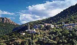 The church and surrounding buildings in Sorio | |
 Sorio Location within Corsica region  Sorio | |
| Coordinates: 42°35′02″N 9°16′28″E / 42.5839°N 9.2744°ECoordinates: 42°35′02″N 9°16′28″E / 42.5839°N 9.2744°E | |
| Country | France |
| Region | Corsica |
| Department | Haute-Corse |
| Arrondissement | Calvi |
| Canton | Biguglia-Nebbio |
| Intercommunality | Nebbiu |
| Government | |
| • Mayor (2008–2014) | Joseph Chiarelli |
| Area1 | 15.56 km2 (6.01 sq mi) |
| Population (2008)2 | 154 |
| • Density | 9.9/km2 (26/sq mi) |
| Time zone | UTC+1 (CET) |
| • Summer (DST) | UTC+2 (CEST) |
| INSEE/Postal code | 2B287 /20246 |
| Elevation |
119–1,535 m (390–5,036 ft) (avg. 400 m or 1,300 ft) |
|
1 French Land Register data, which excludes lakes, ponds, glaciers > 1 km2 (0.386 sq mi or 247 acres) and river estuaries. 2 Population without double counting: residents of multiple communes (e.g., students and military personnel) only counted once. | |
Sorio is a commune in the Haute-Corse department of France on the island of Corsica.
Population
| Historical population | ||
|---|---|---|
| Year | Pop. | ±% |
| 1962 | 154 | — |
| 1968 | 165 | +7.1% |
| 1975 | 141 | −14.5% |
| 1982 | 118 | −16.3% |
| 1990 | 126 | +6.8% |
| 1999 | 148 | +17.5% |
| 2008 | 154 | +4.1% |
See also
References
| Wikimedia Commons has media related to Sorio. |
This article is issued from
Wikipedia.
The text is licensed under Creative Commons - Attribution - Sharealike.
Additional terms may apply for the media files.