Erbajolo
| Erbajolo | |
|---|---|
| Commune | |
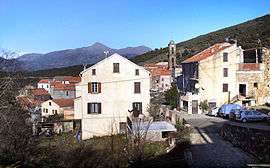 A general view of Erbajolo | |
 Erbajolo Location within Corsica region  Erbajolo | |
| Coordinates: 42°15′54″N 9°17′02″E / 42.265°N 9.2839°ECoordinates: 42°15′54″N 9°17′02″E / 42.265°N 9.2839°E | |
| Country | France |
| Region | Corsica |
| Department | Haute-Corse |
| Arrondissement | Corte |
| Canton | Golo-Morosaglia |
| Government | |
| • Mayor (2014–2020) | Mathieu Mariani |
| Area1 | 15.45 km2 (5.97 sq mi) |
| Population (2015)2 | 107 |
| • Density | 6.9/km2 (18/sq mi) |
| Time zone | UTC+1 (CET) |
| • Summer (DST) | UTC+2 (CEST) |
| INSEE/Postal code | 2B105 /20212 |
| Elevation |
180–924 m (591–3,031 ft) (avg. 750 m or 2,460 ft) |
|
1 French Land Register data, which excludes lakes, ponds, glaciers > 1 km2 (0.386 sq mi or 247 acres) and river estuaries. 2 Population without double counting: residents of multiple communes (e.g., students and military personnel) only counted once. | |
Erbajolo is a commune in the Haute-Corse department of France on the island of Corsica.
Population
| Historical population | ||
|---|---|---|
| Year | Pop. | ±% |
| 1962 | 102 | — |
| 1968 | 132 | +29.4% |
| 1975 | 137 | +3.8% |
| 1982 | 101 | −26.3% |
| 1990 | 90 | −10.9% |
| 1999 | 92 | +2.2% |
| 2006 | 106 | +15.2% |
| 2011 | 103 | −2.8% |
| 2015 | 107 | +3.9% |
Monuments
See also
References
| Wikimedia Commons has media related to Erbajolo. |
This article is issued from
Wikipedia.
The text is licensed under Creative Commons - Attribution - Sharealike.
Additional terms may apply for the media files.