Nocario
| Nocario | |
|---|---|
| Commune | |
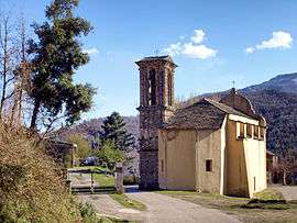 The parish church of Saint-Michel, in Nocario | |
 Nocario Location within Corsica region  Nocario | |
| Coordinates: 42°23′58″N 9°21′06″E / 42.3994°N 9.3517°ECoordinates: 42°23′58″N 9°21′06″E / 42.3994°N 9.3517°E | |
| Country | France |
| Region | Corsica |
| Department | Haute-Corse |
| Arrondissement | Corte |
| Canton | Castagniccia |
| Government | |
| • Mayor (2008–2014) | Paul Battesti |
| Area1 | 3.08 km2 (1.19 sq mi) |
| Population (2008)2 | 56 |
| • Density | 18/km2 (47/sq mi) |
| Time zone | UTC+1 (CET) |
| • Summer (DST) | UTC+2 (CEST) |
| INSEE/Postal code | 2B176 /20229 |
| Elevation |
459–1,766 m (1,506–5,794 ft) (avg. 600 m or 2,000 ft) |
|
1 French Land Register data, which excludes lakes, ponds, glaciers > 1 km2 (0.386 sq mi or 247 acres) and river estuaries. 2 Population without double counting: residents of multiple communes (e.g., students and military personnel) only counted once. | |
Nocario is a commune in the Haute-Corse department of France on the island of Corsica.
Population
| Historical population | ||
|---|---|---|
| Year | Pop. | ±% |
| 1962 | 70 | — |
| 1968 | 90 | +28.6% |
| 1975 | 70 | −22.2% |
| 1982 | 41 | −41.4% |
| 1990 | 33 | −19.5% |
| 1999 | 42 | +27.3% |
| 2008 | 56 | +33.3% |
See also
References
| Wikimedia Commons has media related to Nocario. |
This article is issued from
Wikipedia.
The text is licensed under Creative Commons - Attribution - Sharealike.
Additional terms may apply for the media files.