Campile, Haute-Corse
| Campile | |
|---|---|
| Commune | |
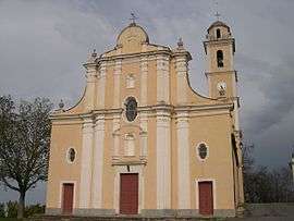 The church of Saint-Pierre and Saint-Paul, in Campile | |
 Campile Location within Corsica region  Campile | |
| Coordinates: 42°29′23″N 9°21′19″E / 42.4897°N 9.3553°ECoordinates: 42°29′23″N 9°21′19″E / 42.4897°N 9.3553°E | |
| Country | France |
| Region | Corsica |
| Department | Haute-Corse |
| Arrondissement | Corte |
| Canton | Golo-Morosaglia |
| Government | |
| • Mayor (2008–2014) | Jean-Marie Vecchioni |
| Area1 | 9.8 km2 (3.8 sq mi) |
| Population (2008)2 | 193 |
| • Density | 20/km2 (51/sq mi) |
| Time zone | UTC+1 (CET) |
| • Summer (DST) | UTC+2 (CEST) |
| INSEE/Postal code | 2B054 /20290 |
| Elevation |
76–1,011 m (249–3,317 ft) (avg. 543 m or 1,781 ft) |
|
1 French Land Register data, which excludes lakes, ponds, glaciers > 1 km2 (0.386 sq mi or 247 acres) and river estuaries. 2 Population without double counting: residents of multiple communes (e.g., students and military personnel) only counted once. | |
Campile is a commune in the Haute-Corse department of France on the island of Corsica. Since 2015, it is part of the canton of Golo-Morosaglia.[1]
Geography
Campile is 18 kilometres (11 mi) south-southeast of Campitello, to the south of the River Golo in Castagniccia.
Population
| Historical population | ||
|---|---|---|
| Year | Pop. | ±% |
| 1962 | 222 | — |
| 1968 | 304 | +36.9% |
| 1975 | 232 | −23.7% |
| 1982 | 242 | +4.3% |
| 1990 | 196 | −19.0% |
| 1999 | 199 | +1.5% |
| 2008 | 193 | −3.0% |
See also
References
| Wikimedia Commons has media related to Campile. |
This article is issued from
Wikipedia.
The text is licensed under Creative Commons - Attribution - Sharealike.
Additional terms may apply for the media files.