Urtaca
| Urtaca | |
|---|---|
| Commune | |
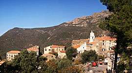 A panorama of the village of Urtaca | |
 Urtaca Location within Corsica region  Urtaca | |
| Coordinates: 42°35′39″N 9°10′03″E / 42.5942°N 9.1675°ECoordinates: 42°35′39″N 9°10′03″E / 42.5942°N 9.1675°E | |
| Country | France |
| Region | Corsica |
| Department | Haute-Corse |
| Arrondissement | Calvi |
| Canton | L'Île-Rousse |
| Government | |
| • Mayor (2008–2014) | Françoise Xavière Montecattini |
| Area1 | 31.26 km2 (12.07 sq mi) |
| Population (2008)2 | 194 |
| • Density | 6.2/km2 (16/sq mi) |
| Time zone | UTC+1 (CET) |
| • Summer (DST) | UTC+2 (CEST) |
| INSEE/Postal code | 2B332 /20218 |
| Elevation |
37–1,367 m (121–4,485 ft) (avg. 380 m or 1,250 ft) |
|
1 French Land Register data, which excludes lakes, ponds, glaciers > 1 km2 (0.386 sq mi or 247 acres) and river estuaries. 2 Population without double counting: residents of multiple communes (e.g., students and military personnel) only counted once. | |
Urtaca is a commune in the Haute-Corse department of France on the island of Corsica.
Geography
Urtaca is located in the north of Corsica at the confluence of the Ostricone and the Fiume di Gargalagne at the foot of 1,018-metre (3,340 ft)-high Mont Vicinasco.
Population
| Historical population | ||
|---|---|---|
| Year | Pop. | ±% |
| 1537 | 134 | — |
| 1729 | 189 | +41.0% |
| 1740 | 180 | −4.8% |
| 1761 | 211 | +17.2% |
| 1769 | 209 | −0.9% |
| 1782 | 211 | +1.0% |
| 1802 | 240 | +13.7% |
| 1807 | 246 | +2.5% |
| 1818 | 280 | +13.8% |
| 1831 | 297 | +6.1% |
| 1836 | 326 | +9.8% |
| 1841 | 317 | −2.8% |
| 1846 | 328 | +3.5% |
| 1851 | 337 | +2.7% |
| 1856 | 323 | −4.2% |
| 1861 | 347 | +7.4% |
| 1866 | 335 | −3.5% |
| 1872 | 360 | +7.5% |
| 1876 | 375 | +4.2% |
| 1881 | 387 | +3.2% |
| 1886 | 410 | +5.9% |
| 1891 | 400 | −2.4% |
| 1896 | 517 | +29.2% |
| 1901 | 501 | −3.1% |
| 1906 | 507 | +1.2% |
| 1911 | 502 | −1.0% |
| 1921 | 292 | −41.8% |
| 1926 | 247 | −15.4% |
| 1931 | 243 | −1.6% |
| 1936 | 257 | +5.8% |
| 1946 | 246 | −4.3% |
| 1954 | 217 | −11.8% |
| 1962 | 220 | +1.4% |
| 1968 | 220 | +0.0% |
| 1975 | 198 | −10.0% |
| 1982 | 178 | −10.1% |
| 1990 | 155 | −12.9% |
| 1999 | 172 | +11.0% |
| 2008 | 194 | +12.8% |
See also
References
| Wikimedia Commons has media related to Urtaca. |
This article is issued from
Wikipedia.
The text is licensed under Creative Commons - Attribution - Sharealike.
Additional terms may apply for the media files.