Penta-Acquatella
| Penta-Acquatella A Penta Acquatella | |
|---|---|
| Commune | |
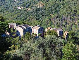 The village of Acquatella, in Penta-Acquatella | |
 Penta-Acquatella Location within Corsica region  Penta-Acquatella | |
| Coordinates: 42°27′46″N 9°21′47″E / 42.4628°N 9.3631°ECoordinates: 42°27′46″N 9°21′47″E / 42.4628°N 9.3631°E | |
| Country | France |
| Region | Corsica |
| Department | Haute-Corse |
| Arrondissement | Corte |
| Canton | Golo-Morosaglia |
| Government | |
| • Mayor (2008–2014) | Marc-Laurent Gatacceca |
| Area1 | 3.1 km2 (1.2 sq mi) |
| Population (1999)2 | 42 |
| • Density | 14/km2 (35/sq mi) |
| Time zone | UTC+1 (CET) |
| • Summer (DST) | UTC+2 (CEST) |
| INSEE/Postal code | 2B206 /20290 |
| Elevation |
237–920 m (778–3,018 ft) (avg. 460 m or 1,510 ft) |
|
1 French Land Register data, which excludes lakes, ponds, glaciers > 1 km2 (0.386 sq mi or 247 acres) and river estuaries. 2 Population without double counting: residents of multiple communes (e.g., students and military personnel) only counted once. | |
Penta-Acquatella is a commune in the Haute-Corse department of France on the island of Corsica.
It is part of the canton of Golo-Morosaglia.[1]
Geography
Penta Acquatella lies south of the river Golo in the Castagniccia, 29 kilometres (18 mi) south-southeast of Campitello.
Population
| Historical population | ||
|---|---|---|
| Year | Pop. | ±% |
| 1962 | 112 | — |
| 1968 | 112 | +0.0% |
| 1975 | 71 | −36.6% |
| 1982 | 53 | −25.4% |
| 1990 | 37 | −30.2% |
| 1999 | 40 | +8.1% |
| 2008 | 42 | +5.0% |
See also
References
| Wikimedia Commons has media related to Penta-Acquatella. |
This article is issued from
Wikipedia.
The text is licensed under Creative Commons - Attribution - Sharealike.
Additional terms may apply for the media files.