Carticasi
| Carticasi | ||
|---|---|---|
| Commune | ||
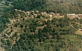 A general view of Carticasi | ||
| ||
 Carticasi Location within Corsica region  Carticasi | ||
| Coordinates: 42°21′28″N 9°17′28″E / 42.3578°N 9.2911°ECoordinates: 42°21′28″N 9°17′28″E / 42.3578°N 9.2911°E | ||
| Country | France | |
| Region | Corsica | |
| Department | Haute-Corse | |
| Arrondissement | Corte | |
| Canton | Golo-Morosaglia | |
| Intercommunality | Vallée de Casaluna | |
| Government | ||
| • Mayor (2008–2014) | Jean Renucci | |
| Area1 | 12.8 km2 (4.9 sq mi) | |
| Population (2008)2 | 31 | |
| • Density | 2.4/km2 (6.3/sq mi) | |
| Time zone | UTC+1 (CET) | |
| • Summer (DST) | UTC+2 (CEST) | |
| INSEE/Postal code | 2B068 /20244 | |
| Elevation |
652–1,697 m (2,139–5,568 ft) (avg. 886 m or 2,907 ft) | |
|
1 French Land Register data, which excludes lakes, ponds, glaciers > 1 km2 (0.386 sq mi or 247 acres) and river estuaries. 2 Population without double counting: residents of multiple communes (e.g., students and military personnel) only counted once. | ||
.svg.png)
Carticasi is a commune in the Haute-Corse department of France on the island of Corsica.
Population
| Historical population | ||
|---|---|---|
| Year | Pop. | ±% |
| 1962 | 44 | — |
| 1968 | 68 | +54.5% |
| 1975 | 55 | −19.1% |
| 1982 | 21 | −61.8% |
| 1990 | 18 | −14.3% |
| 1999 | 26 | +44.4% |
| 2008 | 31 | +19.2% |
See also
References
| Wikimedia Commons has media related to Carticasi. |
This article is issued from
Wikipedia.
The text is licensed under Creative Commons - Attribution - Sharealike.
Additional terms may apply for the media files.