Cambia, Haute-Corse
| Cambia | |
|---|---|
| Commune | |
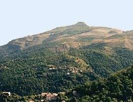 Mount San Petrone and the villages of Cambia and Loriani, in Cambia | |
 Cambia Location within Corsica region  Cambia | |
| Coordinates: 42°21′51″N 9°17′38″E / 42.3642°N 9.2939°ECoordinates: 42°21′51″N 9°17′38″E / 42.3642°N 9.2939°E | |
| Country | France |
| Region | Corsica |
| Department | Haute-Corse |
| Arrondissement | Corte |
| Canton | Golo-Morosaglia |
| Intercommunality | Vallée de Casaluna |
| Government | |
| • Mayor (2008–2014) | Michel Angeli |
| Area1 | 8.28 km2 (3.20 sq mi) |
| Population (2008)2 | 74 |
| • Density | 8.9/km2 (23/sq mi) |
| Time zone | UTC+1 (CET) |
| • Summer (DST) | UTC+2 (CEST) |
| INSEE/Postal code | 2B051 /20244 |
| Elevation |
510–1,421 m (1,673–4,662 ft) (avg. 765 m or 2,510 ft) |
|
1 French Land Register data, which excludes lakes, ponds, glaciers > 1 km2 (0.386 sq mi or 247 acres) and river estuaries. 2 Population without double counting: residents of multiple communes (e.g., students and military personnel) only counted once. | |
Cambia is a commune in the Haute-Corse department of France on the island of Corsica.
Population
| Historical population | ||
|---|---|---|
| Year | Pop. | ±% |
| 1962 | 112 | — |
| 1968 | 116 | +3.6% |
| 1975 | 89 | −23.3% |
| 1982 | 80 | −10.1% |
| 1990 | 81 | +1.2% |
| 1999 | 79 | −2.5% |
| 2008 | 74 | −6.3% |
See also
References
| Wikimedia Commons has media related to Cambia. |
This article is issued from
Wikipedia.
The text is licensed under Creative Commons - Attribution - Sharealike.
Additional terms may apply for the media files.