Occhiatana
| Occhiatana | |
|---|---|
| Commune | |
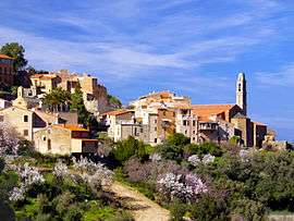 The church and surrounding buildings in Occhiatana | |
 Occhiatana Location within Corsica region  Occhiatana | |
| Coordinates: 42°34′30″N 9°00′33″E / 42.575°N 9.0092°ECoordinates: 42°34′30″N 9°00′33″E / 42.575°N 9.0092°E | |
| Country | France |
| Region | Corsica |
| Department | Haute-Corse |
| Arrondissement | Calvi |
| Canton | L'Île-Rousse |
| Intercommunality | E Cinque Pieve di Balagna |
| Government | |
| • Mayor (2008–2014) | Jean Pasquin Mattei |
| Area1 | 12.62 km2 (4.87 sq mi) |
| Population (2008)2 | 174 |
| • Density | 14/km2 (36/sq mi) |
| Time zone | UTC+1 (CET) |
| • Summer (DST) | UTC+2 (CEST) |
| INSEE/Postal code | 2B182 /20226 |
| Elevation |
0–1,163 m (0–3,816 ft) (avg. 350 m or 1,150 ft) |
|
1 French Land Register data, which excludes lakes, ponds, glaciers > 1 km2 (0.386 sq mi or 247 acres) and river estuaries. 2 Population without double counting: residents of multiple communes (e.g., students and military personnel) only counted once. | |
Occhiatana is a commune in the Haute-Corse department of France on the island of Corsica.
Population
| Historical population | ||
|---|---|---|
| Year | Pop. | ±% |
| 1962 | 129 | — |
| 1968 | 154 | +19.4% |
| 1975 | 178 | +15.6% |
| 1982 | 185 | +3.9% |
| 1990 | 165 | −10.8% |
| 1999 | 163 | −1.2% |
| 2008 | 174 | +6.7% |
See also
References
| Wikimedia Commons has media related to Occhiatana. |
This article is issued from
Wikipedia.
The text is licensed under Creative Commons - Attribution - Sharealike.
Additional terms may apply for the media files.