Alando, Haute-Corse
| Alando | |
|---|---|
| Commune | |
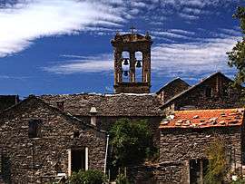 Former convent | |
 Alando Location within Corsica region  Alando | |
| Coordinates: 42°18′26″N 9°17′28″E / 42.3072°N 9.2911°ECoordinates: 42°18′26″N 9°17′28″E / 42.3072°N 9.2911°E | |
| Country | France |
| Region | Corsica |
| Department | Haute-Corse |
| Arrondissement | Corte |
| Canton | Golo-Morosaglia |
| Intercommunality | di E tre pieve : Bozio, Mercoriu e Rogna |
| Government | |
| • Mayor (2014-2020) | Guy Mamelli |
| Area1 | 3.05 km2 (1.18 sq mi) |
| Population (2014)2 | 31 |
| • Density | 10/km2 (26/sq mi) |
| Time zone | UTC+1 (CET) |
| • Summer (DST) | UTC+2 (CEST) |
| INSEE/Postal code | 2B005 /20250 |
| Elevation |
480–1,040 m (1,570–3,410 ft) (avg. 660 m or 2,170 ft) |
|
1 French Land Register data, which excludes lakes, ponds, glaciers > 1 km2 (0.386 sq mi or 247 acres) and river estuaries. 2 Population without double counting: residents of multiple communes (e.g., students and military personnel) only counted once. | |
Alando is a commune in the Haute-Corse department of France on the island of Corsica.
Population
| Historical population | ||
|---|---|---|
| Year | Pop. | ±% |
| 1962 | 50 | — |
| 1968 | 51 | +2.0% |
| 1975 | 42 | −17.6% |
| 1982 | 38 | −9.5% |
| 1990 | 15 | −60.5% |
| 1999 | 23 | +53.3% |
| 2008 | 27 | +17.4% |
See also
References
| Wikimedia Commons has media related to Alando. |
This article is issued from
Wikipedia.
The text is licensed under Creative Commons - Attribution - Sharealike.
Additional terms may apply for the media files.