Sainte-Marie-d'Alloix
| Sainte-Marie-d'Alloix | |
|---|---|
| Commune | |
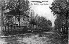 The town hall and schools in 1912 | |
 Sainte-Marie-d'Alloix Location within Auvergne-Rhône-Alpes region  Sainte-Marie-d'Alloix | |
| Coordinates: 45°22′59″N 5°58′01″E / 45.383°N 5.967°ECoordinates: 45°22′59″N 5°58′01″E / 45.383°N 5.967°E | |
| Country | France |
| Region | Auvergne-Rhône-Alpes |
| Department | Isère |
| Arrondissement | Grenoble |
| Canton | Le Haut-Grésivaudan |
| Intercommunality | CC Le Grésivaudan |
| Government | |
| • Mayor (2014–2020) | Christian Benone |
| Area1 | 3 km2 (1 sq mi) |
| Population (2011)2 | 552 |
| • Density | 180/km2 (480/sq mi) |
| Time zone | UTC+1 (CET) |
| • Summer (DST) | UTC+2 (CEST) |
| INSEE/Postal code | 38417 /38660 |
| Elevation |
242–380 m (794–1,247 ft) (avg. 248 m or 814 ft) |
|
1 French Land Register data, which excludes lakes, ponds, glaciers > 1 km2 (0.386 sq mi or 247 acres) and river estuaries. 2 Population without double counting: residents of multiple communes (e.g., students and military personnel) only counted once. | |
Sainte-Marie-d'Alloix is a commune in the Isère department in southeastern France.
Population
| Historical population | ||
|---|---|---|
| Year | Pop. | ±% |
| 1793 | 312 | — |
| 1806 | 347 | +11.2% |
| 1821 | 303 | −12.7% |
| 1831 | 332 | +9.6% |
| 1841 | 350 | +5.4% |
| 1851 | 350 | +0.0% |
| 1861 | 342 | −2.3% |
| 1872 | 236 | −31.0% |
| 1881 | 305 | +29.2% |
| 1891 | 268 | −12.1% |
| 1901 | 238 | −11.2% |
| 1911 | 210 | −11.8% |
| 1921 | 220 | +4.8% |
| 1931 | 202 | −8.2% |
| 1946 | 206 | +2.0% |
| 1954 | 219 | +6.3% |
| 1962 | 208 | −5.0% |
| 1968 | 186 | −10.6% |
| 1975 | 211 | +13.4% |
| 1982 | 308 | +46.0% |
| 1990 | 413 | +34.1% |
| 1999 | 568 | +37.5% |
| 2006 | 568 | +0.0% |
| 2011 | 552 | −2.8% |
See also
References
| Wikimedia Commons has media related to Sainte-Marie-d'Alloix. |
This article is issued from
Wikipedia.
The text is licensed under Creative Commons - Attribution - Sharealike.
Additional terms may apply for the media files.