Saint-Front, Haute-Loire
| Saint-Front | |
|---|---|
| Commune | |
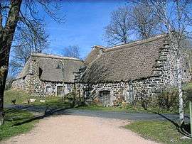 Mezenc cottages | |
 Saint-Front Location within Auvergne-Rhône-Alpes region  Saint-Front | |
| Coordinates: 44°58′41″N 4°08′35″E / 44.9781°N 4.1431°ECoordinates: 44°58′41″N 4°08′35″E / 44.9781°N 4.1431°E | |
| Country | France |
| Region | Auvergne-Rhône-Alpes |
| Department | Haute-Loire |
| Arrondissement | Le Puy-en-Velay |
| Canton | Mézenc |
| Government | |
| • Mayor (2001–2008) | Philippe Delabre |
| Area1 | 52.33 km2 (20.20 sq mi) |
| Population (1999)2 | 509 |
| • Density | 9.7/km2 (25/sq mi) |
| Time zone | UTC+1 (CET) |
| • Summer (DST) | UTC+2 (CEST) |
| INSEE/Postal code | 43186 /43550 |
| Elevation |
796–1,594 m (2,612–5,230 ft) (avg. 1,223 m or 4,012 ft) |
|
1 French Land Register data, which excludes lakes, ponds, glaciers > 1 km2 (0.386 sq mi or 247 acres) and river estuaries. 2 Population without double counting: residents of multiple communes (e.g., students and military personnel) only counted once. | |
Saint-Front is a commune in the Haute-Loire department in south-central France.
Geography
The river Lignon du Velay forms most of the commune's southeastern border.
Gallery
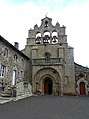 The Church of Saint-Front
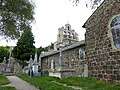 The Church and the old Cemetery
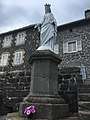 Statue of the Virgin Mary
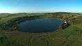 The lake of Saint-Front
See also
References
| Wikimedia Commons has media related to Saint-Front (Haute-Loire). |
This article is issued from
Wikipedia.
The text is licensed under Creative Commons - Attribution - Sharealike.
Additional terms may apply for the media files.