Champagnac-le-Vieux
| Champagnac-le-Vieux | |
|---|---|
| Commune | |
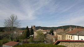 A general view of Champagnac-le-Vieux | |
 Champagnac-le-Vieux Location within Auvergne-Rhône-Alpes region  Champagnac-le-Vieux | |
| Coordinates: 45°21′31″N 3°30′13″E / 45.3586°N 3.5036°ECoordinates: 45°21′31″N 3°30′13″E / 45.3586°N 3.5036°E | |
| Country | France |
| Region | Auvergne-Rhône-Alpes |
| Department | Haute-Loire |
| Arrondissement | Brioude |
| Canton | Sainte-Florine |
| Intercommunality | Auzon Communauté |
| Government | |
| • Mayor (2014–2010) | Michel Mignot |
| Area1 | 20.61 km2 (7.96 sq mi) |
| Population (2014)2 | 215 |
| • Density | 10/km2 (27/sq mi) |
| Time zone | UTC+1 (CET) |
| • Summer (DST) | UTC+2 (CEST) |
| INSEE/Postal code | 43052 /43440 |
| Elevation | 640–980 m (2,100–3,220 ft) |
|
1 French Land Register data, which excludes lakes, ponds, glaciers > 1 km2 (0.386 sq mi or 247 acres) and river estuaries. 2 Population without double counting: residents of multiple communes (e.g., students and military personnel) only counted once. | |
Champagnac-le-Vieux is a commune in the Haute-Loire department and Auvergne-Rhône-Alpes region of south-east central France.
Population
| Historical population | ||
|---|---|---|
| Year | Pop. | ±% |
| 1946 | 564 | — |
| 1954 | 535 | −5.1% |
| 1962 | 520 | −2.8% |
| 1968 | 486 | −6.5% |
| 1975 | 415 | −14.6% |
| 1982 | 340 | −18.1% |
| 1990 | 301 | −11.5% |
| 1999 | 277 | −8.0% |
| 2009 | 234 | −15.5% |
| 2014 | 215 | −8.1% |
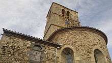
St Peter's church in Champagnac-le-Vieux
See also
| Wikimedia Commons has media related to Champagnac-le-Vieux. |
This article is issued from
Wikipedia.
The text is licensed under Creative Commons - Attribution - Sharealike.
Additional terms may apply for the media files.