Craponne-sur-Arzon
| Craponne-sur-Arzon | ||
|---|---|---|
| Commune | ||
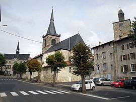 From left to right: The town hall, the church of Saint-Caprais and the "dungeon" | ||
| ||
 Craponne-sur-Arzon Location within Auvergne-Rhône-Alpes region  Craponne-sur-Arzon | ||
| Coordinates: 45°19′55″N 3°50′56″E / 45.3319°N 3.8489°ECoordinates: 45°19′55″N 3°50′56″E / 45.3319°N 3.8489°E | ||
| Country | France | |
| Region | Auvergne-Rhône-Alpes | |
| Department | Haute-Loire | |
| Arrondissement | Le Puy-en-Velay | |
| Canton | Plateau du Haut-Velay granitique | |
| Government | ||
| • Mayor (2014–2020) | Laurent Mirmand | |
| Area1 | 33.37 km2 (12.88 sq mi) | |
| Population (2014)2 | 2,129 | |
| • Density | 64/km2 (170/sq mi) | |
| Time zone | UTC+1 (CET) | |
| • Summer (DST) | UTC+2 (CEST) | |
| INSEE/Postal code | 43080 /43500 | |
| Elevation |
771–1,063 m (2,530–3,488 ft) (avg. 937 m or 3,074 ft) | |
|
1 French Land Register data, which excludes lakes, ponds, glaciers > 1 km2 (0.386 sq mi or 247 acres) and river estuaries. 2 Population without double counting: residents of multiple communes (e.g., students and military personnel) only counted once. | ||

Craponne-sur-Arzon (Auvergnat: Crapòna) is a commune in the Haute-Loire department in south-central France.
See also
| Wikimedia Commons has media related to Craponne-sur-Arzon. |
This article is issued from
Wikipedia.
The text is licensed under Creative Commons - Attribution - Sharealike.
Additional terms may apply for the media files.