Vernassal
| Vernassal | |
|---|---|
| Commune | |
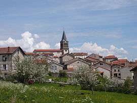 The church and surrounding buildings, in Vernassal | |
 Vernassal Location within Auvergne-Rhône-Alpes region  Vernassal | |
| Coordinates: 45°09′00″N 3°42′13″E / 45.15°N 3.7036°ECoordinates: 45°09′00″N 3°42′13″E / 45.15°N 3.7036°E | |
| Country | France |
| Region | Auvergne-Rhône-Alpes |
| Department | Haute-Loire |
| Arrondissement | Le Puy-en-Velay |
| Canton | Saint-Paulien |
| Government | |
| • Mayor | Michel Chouvier |
| Area1 | 19.23 km2 (7.42 sq mi) |
| Population (1999)2 | 332 |
| • Density | 17/km2 (45/sq mi) |
| Time zone | UTC+1 (CET) |
| • Summer (DST) | UTC+2 (CEST) |
| INSEE/Postal code | 43259 /43270 |
| Elevation |
850–1,163 m (2,789–3,816 ft) (avg. 886 m or 2,907 ft) |
|
1 French Land Register data, which excludes lakes, ponds, glaciers > 1 km2 (0.386 sq mi or 247 acres) and river estuaries. 2 Population without double counting: residents of multiple communes (e.g., students and military personnel) only counted once. | |
Vernassal is a commune in the Haute-Loire department in south-central France.
See also
| Wikimedia Commons has media related to Vernassal. |
This article is issued from
Wikipedia.
The text is licensed under Creative Commons - Attribution - Sharealike.
Additional terms may apply for the media files.