Grenier-Montgon
| Grenier-Montgon | |
|---|---|
| Commune | |
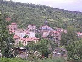 The village of Grenier | |
 Grenier-Montgon Location within Auvergne-Rhône-Alpes region  Grenier-Montgon | |
| Coordinates: 45°17′19″N 3°11′44″E / 45.2886°N 3.1956°ECoordinates: 45°17′19″N 3°11′44″E / 45.2886°N 3.1956°E | |
| Country | France |
| Region | Auvergne-Rhône-Alpes |
| Department | Haute-Loire |
| Arrondissement | Brioude |
| Canton | Sainte-Florine |
| Government | |
| • Mayor (2008–2014) | Jean Darcellier |
| Area1 | 5.01 km2 (1.93 sq mi) |
| Population (1999)2 | 123 |
| • Density | 25/km2 (64/sq mi) |
| Time zone | UTC+1 (CET) |
| • Summer (DST) | UTC+2 (CEST) |
| INSEE/Postal code | 43103 /43450 |
| Elevation | 504–694 m (1,654–2,277 ft) |
|
1 French Land Register data, which excludes lakes, ponds, glaciers > 1 km2 (0.386 sq mi or 247 acres) and river estuaries. 2 Population without double counting: residents of multiple communes (e.g., students and military personnel) only counted once. | |
Grenier-Montgon is a commune in the Haute-Loire department in south-central France.
See also
| Wikimedia Commons has media related to Grenier-Montgon. |
This article is issued from
Wikipedia.
The text is licensed under Creative Commons - Attribution - Sharealike.
Additional terms may apply for the media files.