Saint-Julien-Chapteuil
| Saint-Julien-Chapteuil | ||
|---|---|---|
| Commune | ||
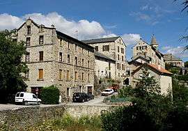 A general view of Saint-Julien-Chapteuil | ||
| ||
 Saint-Julien-Chapteuil Location within Auvergne-Rhône-Alpes region  Saint-Julien-Chapteuil | ||
| Coordinates: 45°02′09″N 4°03′42″E / 45.0358°N 4.0617°ECoordinates: 45°02′09″N 4°03′42″E / 45.0358°N 4.0617°E | ||
| Country | France | |
| Region | Auvergne-Rhône-Alpes | |
| Department | Haute-Loire | |
| Arrondissement | Le Puy-en-Velay | |
| Canton | Emblavez-et-Meygal | |
| Government | ||
| • Mayor (2008–2014) | André Ferret | |
| Area1 | 28.26 km2 (10.91 sq mi) | |
| Population (1999)2 | 1,804 | |
| • Density | 64/km2 (170/sq mi) | |
| Time zone | UTC+1 (CET) | |
| • Summer (DST) | UTC+2 (CEST) | |
| INSEE/Postal code | 43200 /43260 | |
| Elevation |
771–1,408 m (2,530–4,619 ft) (avg. 821 m or 2,694 ft) | |
|
1 French Land Register data, which excludes lakes, ponds, glaciers > 1 km2 (0.386 sq mi or 247 acres) and river estuaries. 2 Population without double counting: residents of multiple communes (e.g., students and military personnel) only counted once. | ||

Saint-Julien-Chapteuil (Auvergnat: Sant Julian e Chaptuèlh) is a commune in the Haute-Loire department in south-central France.
See also
References
| Wikimedia Commons has media related to Saint-Julien-Chapteuil. |
This article is issued from
Wikipedia.
The text is licensed under Creative Commons - Attribution - Sharealike.
Additional terms may apply for the media files.