Tiranges
| Tiranges | |
|---|---|
| Commune | |
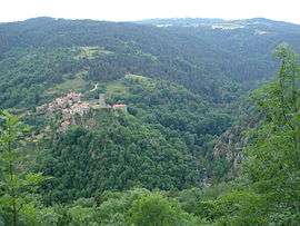 Tiranges, overlooking the gorges of Ance and Château de Chalencon | |
 Tiranges Location within Auvergne-Rhône-Alpes region  Tiranges | |
| Coordinates: 45°18′18″N 3°59′20″E / 45.305°N 3.9889°ECoordinates: 45°18′18″N 3°59′20″E / 45.305°N 3.9889°E | |
| Country | France |
| Region | Auvergne-Rhône-Alpes |
| Department | Haute-Loire |
| Arrondissement | Yssingeaux |
| Canton | Bas-en-Basset |
| Government | |
| • Mayor | Colette Gaillard |
| Area1 | 26.83 km2 (10.36 sq mi) |
| Population (2006)2 | 430 |
| • Density | 16/km2 (42/sq mi) |
| Time zone | UTC+1 (CET) |
| • Summer (DST) | UTC+2 (CEST) |
| INSEE/Postal code | 43246 /43530 |
| Elevation |
489–921 m (1,604–3,022 ft) (avg. 830 m or 2,720 ft) |
|
1 French Land Register data, which excludes lakes, ponds, glaciers > 1 km2 (0.386 sq mi or 247 acres) and river estuaries. 2 Population without double counting: residents of multiple communes (e.g., students and military personnel) only counted once. | |
Tiranges is a commune in the Haute-Loire department in south-central France.
See also
| Wikimedia Commons has media related to Tiranges. |
This article is issued from
Wikipedia.
The text is licensed under Creative Commons - Attribution - Sharealike.
Additional terms may apply for the media files.