Chavaniac-Lafayette
| Chavaniac-Lafayette | |
|---|---|
| Commune | |
 | |
 Chavaniac-Lafayette Location within Auvergne-Rhône-Alpes region  Chavaniac-Lafayette | |
| Coordinates: 45°09′34″N 3°34′52″E / 45.1594°N 3.5811°ECoordinates: 45°09′34″N 3°34′52″E / 45.1594°N 3.5811°E | |
| Country | France |
| Region | Auvergne-Rhône-Alpes |
| Department | Haute-Loire |
| Arrondissement | Brioude |
| Canton | Pays de Lafayette |
| Government | |
| • Mayor | Hélène Mansot |
| Area1 | 8.41 km2 (3.25 sq mi) |
| Population (1999)2 | 293 |
| • Density | 35/km2 (90/sq mi) |
| Time zone | UTC+1 (CET) |
| • Summer (DST) | UTC+2 (CEST) |
| INSEE/Postal code | 43067 /43230 |
| Elevation |
620–1,046 m (2,034–3,432 ft) (avg. 714 m or 2,343 ft) |
|
1 French Land Register data, which excludes lakes, ponds, glaciers > 1 km2 (0.386 sq mi or 247 acres) and river estuaries. 2 Population without double counting: residents of multiple communes (e.g., students and military personnel) only counted once. | |
Chavaniac-Lafayette is a commune in the Haute-Loire department in south-central France.
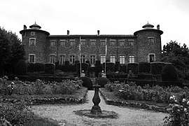
The Château de Chavaniac, located in the commune, was the birthplace of Gilbert du Motier, marquis de Lafayette in 1757. Originally named Chavaniac, the commune was renamed Chavaniac-Lafayette in 1884 in honor of its most famous resident.
Gallery
See also
| Wikimedia Commons has media related to Chavaniac-Lafayette. |
This article is issued from
Wikipedia.
The text is licensed under Creative Commons - Attribution - Sharealike.
Additional terms may apply for the media files.