Cayres
| Cayres | ||
|---|---|---|
| Commune | ||
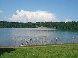 Beach at Lake Bouchet, with restaurant on the far side | ||
| ||
 Cayres Location within Auvergne-Rhône-Alpes region  Cayres | ||
| Coordinates: 44°55′35″N 3°48′28″E / 44.9264°N 3.8078°ECoordinates: 44°55′35″N 3°48′28″E / 44.9264°N 3.8078°E | ||
| Country | France | |
| Region | Auvergne-Rhône-Alpes | |
| Department | Haute-Loire | |
| Arrondissement | Le Puy-en-Velay | |
| Canton | Velay volcanique | |
| Intercommunality | Pays de Cayres et de Pradelles | |
| Government | ||
| • Mayor (2014–2020) | Philippe Mazet | |
| Area1 | 29.22 km2 (11.28 sq mi) | |
| Population (2014)2 | 720 | |
| • Density | 25/km2 (64/sq mi) | |
| Time zone | UTC+1 (CET) | |
| • Summer (DST) | UTC+2 (CEST) | |
| INSEE/Postal code | 43042 /43510 | |
| Elevation |
971–1,382 m (3,186–4,534 ft) (avg. 1,180 m or 3,870 ft) | |
|
1 French Land Register data, which excludes lakes, ponds, glaciers > 1 km2 (0.386 sq mi or 247 acres) and river estuaries. 2 Population without double counting: residents of multiple communes (e.g., students and military personnel) only counted once. | ||

Cayres is a commune in the Haute-Loire department and Auvergne-Rhône-Alpes region of south-east central France.
Population
| Historical population | ||
|---|---|---|
| Year | Pop. | ±% |
| 1946 | 887 | — |
| 1954 | 814 | −8.2% |
| 1962 | 791 | −2.8% |
| 1968 | 699 | −11.6% |
| 1975 | 614 | −12.2% |
| 1982 | 589 | −4.1% |
| 1990 | 511 | −13.2% |
| 1999 | 613 | +20.0% |
| 2005 | 698 | +13.9% |
| 2014 | 720 | +3.2% |
See also
| Wikimedia Commons has media related to Cayres. |
This article is issued from
Wikipedia.
The text is licensed under Creative Commons - Attribution - Sharealike.
Additional terms may apply for the media files.