Les Estables
| Les Estables | |
|---|---|
| Commune | |
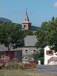 The church and the village of Les Estables | |
 Les Estables Location within Auvergne-Rhône-Alpes region  Les Estables | |
| Coordinates: 44°54′19″N 4°09′18″E / 44.9053°N 4.155°ECoordinates: 44°54′19″N 4°09′18″E / 44.9053°N 4.155°E | |
| Country | France |
| Region | Auvergne-Rhône-Alpes |
| Department | Haute-Loire |
| Arrondissement | Le Puy-en-Velay |
| Canton | Mézenc |
| Government | |
| • Mayor | Paul Michel |
| Area1 | 33.94 km2 (13.10 sq mi) |
| Population (1999)2 | 325 |
| • Density | 9.6/km2 (25/sq mi) |
| Time zone | UTC+1 (CET) |
| • Summer (DST) | UTC+2 (CEST) |
| INSEE/Postal code | 43091 /43150 |
| Elevation |
1,033–1,725 m (3,389–5,659 ft) (avg. 1,346 m or 4,416 ft) |
|
1 French Land Register data, which excludes lakes, ponds, glaciers > 1 km2 (0.386 sq mi or 247 acres) and river estuaries. 2 Population without double counting: residents of multiple communes (e.g., students and military personnel) only counted once. | |
Les Estables is a commune in the Haute-Loire department in south-central France.
See also
| Wikimedia Commons has media related to Les Estables. |
This article is issued from
Wikipedia.
The text is licensed under Creative Commons - Attribution - Sharealike.
Additional terms may apply for the media files.