Stewarts Point, California
| Stewarts, California | |
|---|---|
| Unincorporated community | |
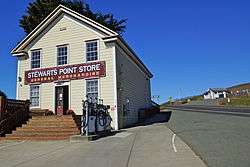 General Store | |
 Stewarts, California | |
| Coordinates: 38°39′07″N 123°23′57″W / 38.65194°N 123.39917°WCoordinates: 38°39′07″N 123°23′57″W / 38.65194°N 123.39917°W | |
| Country | United States |
| State | California |
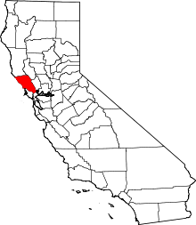
| County | Sonoma |
| Elevation | 108 ft (33 m) |
| Time zone | UTC-8 (Pacific (PST)) |
| • Summer (DST) | UTC-7 (PDT) |
| ZIP code | 95480 |
| Area code(s) | 707 |
| GNIS feature ID | 252807[1] |
Stewarts Point is an unincorporated community in Sonoma County, California, United States. Stewarts Point is located on the Pacific coast and California State Route 1 20 miles (32 km) west of Healdsburg. Stewarts Point has a post office which was established in 1888.[2] The community is named after the Stewart family, who moved to the area in 1856.[3]
Stewarts Point is the home of the Kashia Band of Pomo Indians of the Stewarts Point Rancheria.
Stewarts Point was named for Lt. Col. C.S. Stewart of the Corps of Engineers, who in 1875 removed Noonday Rock from the Farallones.[4]
References
- ↑ U.S. Geological Survey Geographic Names Information System: Stewarts Point, California
- ↑ ZIP Code Lookup
- ↑ Durham, David L. (1998). California's Geographic Names: A Gazetteer of Historic and Modern Names of the State. Quill Driver Books. p. 707. ISBN 1-884995-14-4.
- ↑ Capace, Nancy (1999). Encyclopedia of California. North American Book Dist LLC. Page 443. ISBN 9780403093182.
External links
![]()
This article is issued from
Wikipedia.
The text is licensed under Creative Commons - Attribution - Sharealike.
Additional terms may apply for the media files.