Bodega Bay, California
| Bodega Bay Port Rumyantsev | |
|---|---|
| Census-designated place | |
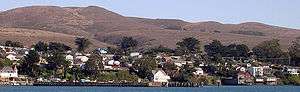 Bodega Bay in 2008, seen from across the harbor | |
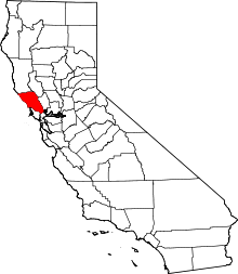
 Location in Sonoma County and the state of California | |
 Bodega Bay Location in the United States | |
| Coordinates: 38°19′28″N 123°2′19″W / 38.32444°N 123.03861°WCoordinates: 38°19′28″N 123°2′19″W / 38.32444°N 123.03861°W[1] | |
| Country |
|
| State | California |
| County | Sonoma |
| Area[2] | |
| • Total | 12.52 sq mi (32.44 km2) |
| • Land | 8.35 sq mi (21.61 km2) |
| • Water | 4.18 sq mi (10.82 km2) 33.37% |
| Elevation[3] | 56 ft (17 m) |
| Population (2010) | |
| • Total | 1,077 |
| • Estimate (2016)[4] | N/A |
| Time zone | UTC−8 (Pacific) |
| • Summer (DST) | UTC−7 (PDT) |
| ZIP Code | 94923 |
| Area code | 707 |
| FIPS code | 06-07260 |
| GNIS feature IDs | 1658093, 2407872 |
Bodega Bay is a town and census-designated place (CDP) in Sonoma County, California, United States. The population was 1,077 at the 2010 census. The town, located along State Route 1, is on the eastern side of Bodega Harbor, an inlet of Bodega Bay on the Pacific coast.
History
Bodega Bay is the site of the first Russian structures built in California, which were built in 1809 by Commerce Counseller Ivan Alexandrovich Kuskov of the Russian-American Company in the lead-up to the establishment of Fort Ross. For the Russians, the settlement in Bodega Bay was called Port Rumyantsev, named after the Russian Foreign Minister Nikolai Petrovich Rumyantsev, and it served as a port to support Fort Ross and the larger Russian community known as Colony Ross.[5][6]
The location scenes in the Alfred Hitchcock-directed film The Birds (1963) were filmed in both Bodega Bay and nearby Bodega (though both were represented as being parts of the movie's Bodega Bay.) The town markets itself with the film in many ways, including its Birds-themed visitors' center, although none of the film's primary locations are found there. The church and schoolhouse shown in the film are located on Bodega Hwy in Bodega[7]. The town was also featured in the cult horror movie Puppet Master (1989).
PG+E wanted to build a nuclear power plant on Bodega Head in the 1960s, but the plans were shut down after a large protest (the first for environmental reasons) and the fault, which they found while they were digging the hole for the first reactor. The hole filled with water and became known as "The Hole in the Head".
Geography
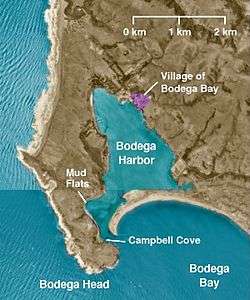
According to the United States Census Bureau, the CDP has a total area of 12.5 square miles (32 km2), 8.3 square miles (21 km2) of it is land, and 4.2 square miles (11 km2) of it (33.37%) is water. The town lies on the edge of Bodega Harbor. Bodega Bay itself extends south along the coast to Tomales Bay. North of town lies a long coastal exposure of alternating rock outcrops and sandy beaches which is known as Sonoma Coast State Beach.
The U.S. National Weather Service provides a helpful visual aid[8] graphing weather and climate information from the nearby Monterey sensors to display visually by month the annual typical temperatures, the past year's temperatures, and record temperatures.
Climate
This region experiences warm (but not hot) and dry summers, with no average monthly temperatures above 71.6 °F. According to the Köppen Climate Classification system, Bodega Bay has a warm-summer Mediterranean climate, abbreviated "Csb" on climate maps.[9] Like much of the California coast, summer afternoons are often cool and windy (and sometimes foggy) as winds blow in off the ocean.
Demographics
| Historical population | |||
|---|---|---|---|
| Census | Pop. | %± | |
| U.S. Decennial Census[10] | |||
2010 Census data
The 2010 United States Census[11] reported that Bodega Bay had a population of 1,077. The population density was 86.0 people per square mile (33.2/km²). The ethnic makeup of Bodega Bay was 951 (88.3%) White, 2 (0.2%) African American, 4 (0.4%) Native American, 33 (3.1%) Asian, 4 (0.4%) Pacific Islander, 49 (4.5%) from other races, and 34 (3.2%) from two or more races. Hispanic or Latino of any race were 126 persons (11.7%).
The Census reported that 99.0% of the population lived in households and 1.0% lived in non-institutionalized group quarters.
There were 533 households, out of which 77 (14.4%) had children under the age of 18 living in them, 278 (52.2%) were opposite-sex married couples living together, 22 (4.1%) had a female householder with no husband present, 14 (2.6%) had a male householder with no wife present. There were 33 (6.2%) unmarried opposite-sex partnerships, and 8 (1.5%) same-sex married couples or partnerships. 170 households (31.9%) were made up of individuals and 67 (12.6%) had someone living alone who was 65 years of age or older. The average household size was 2.00. There were 314 families (58.9% of all households); the average family size was 2.48.
The population was spread out with 131 people (12.2%) under the age of 18, 52 people (4.8%) aged 18 to 24, 172 people (16.0%) aged 25 to 44, 409 people (38.0%) aged 45 to 64, and 313 people (29.1%) who were 65 years of age or older. The median age was 57.2 years. For every 100 females, there were 105.9 males. For every 100 females age 18 and over, there were 106.1 males.
There were 1,060 housing units at an average density of 84.6 per square mile (32.7/km²), of which 67.9% were owner-occupied and 32.1% were occupied by renters. The homeowner vacancy rate was 4.6%; the rental vacancy rate was 23.7%. 65.3% of the population lived in owner-occupied housing units and 33.7% lived in rental housing units.
2000 Census data
As of the census[12] of 2000, there were 1,423 people, 669 households, and 432 families residing in the CDP. The population density was 169.7 per square mile (65.6/km²). There were 1,144 housing units at an average density of 136.4 per square mile (52.7/km²). The racial makeup of the CDP was 85.52% White, 0.35% African American, 1.55% Native American, 1.34% Asian, 9.07% from other races, and 2.18% from two or more races. Hispanic or Latino of any race were 15.18% of the population. There were 669 households out of which 14.5% had children under the age of 18 living with them, 57.5% were married couples living together, 3.9% had a female householder with no husband present, and 35.4% were non-families. 27.2% of all households were made up of individuals and 9.1% had someone living alone who was 65 years of age or older. The average household size was 2.11 and the average family size was 2.47.
In the CDP, the population was 12.7% under the age of 18, 6.2% from 18 to 24, 21.7% from 25 to 44, 36.5% from 45 to 64, and 22.8% who were 65 years of age or older. The median age was 51 years. For every 100 females, there were 108.0 males. For every 100 females age 18 and over, there were 106.3 males. The median income for a household in the CDP was $56,818, and the median income for a family was $60,750. Males had a median income of $27,778 versus $28,375 for females. The per capita income for the CDP was $37,226. About 2.0% of families and 4.0% of the population were below the poverty line, including none of those under the age of eighteen or sixty-five or over.
Government
In the California State Legislature, Bodega Bay is in the 2nd Senate District, represented by Democrat Mike McGuire, and in the 2nd Assembly District, represented by Democrat Jim Wood.[13]
In the United States House of Representatives, Bodega Bay is in California's 2nd congressional district, represented by Democrat Jared Huffman.[14]
Notable people

Bodega Bay was the hometown of Nicholas Green, the American child shot dead during a robbery by highwaymen in Italy where his family were on vacation in 1994. Nicholas and his family became famous when almost every harvestable organ or body part was donated to those in need following his death.[15]
Erden Eruç made history here when he completed the first entirely solo and entirely human-powered circumnavigation of the Earth. He began the expedition on 10 July 2007 in Bodega Bay and returned a little more than five years later on 21 July 2012.[16][17]
Film locations
Bodega Bay has served as a location for several major films:[18][19][20]
- The Birds (1963) Except for a short sequence at the beginning filmed in San Francisco, most of the film's exterior scenes were filmed around the two towns of Bodega (a small inland village) and Bodega Bay (a larger village on the bay). Special sites used for shooting included Potter School, the Bay, the two towns which were made to appear as one, and the home and barn across the bay from the town of Bodega Bay.
- The Russians Are Coming, the Russians Are Coming (1966) Some scenes filmed in Bodega Bay.
- The Pack (1977) Filmed around Bodega Bay.
- The Fog (1980)
- The Goonies (1985) Some scenes filmed along the Sonoma Coast, Bodega Bay (and Astoria OR, and Cannon Beach OR).
- Puppet Master (1989) Setting is Bodega Bay for the first two, fourth and fifth films.
- Sleepwalkers (1992) Opening scene filmed in Bodega Bay.
- Hart to Hart: Home Is Where the Hart Is (1994 TV Movie) Exterior scenes of the town.
- I Know What You Did Last Summer (1997) Scenes around the road accident.
Other facilities
A branch of the University of California operates a marine lab at Bodega Bay, the Bodega Marine Laboratory.[21]
A nuclear power plant had been planned for Bodega Bay in the 1960s but was abandoned after both local and statewide protests and the discovery of a fault across the proposed site. Excavation for the site began at Bodega Head, and when the project was abandoned the area has been referred to by locals as "The Hole in the Head."[22]
References
- ↑ "US Gazetteer files: 2010, 2000, and 1990". United States Census Bureau. 2011-02-12. Retrieved 2011-04-23.
- ↑ "2016 U.S. Gazetteer Files". United States Census Bureau. Retrieved Jul 19, 2017.
- ↑ U.S. Geological Survey Geographic Names Information System: Bodega Bay
- ↑ "Population and Housing Unit Estimates". Retrieved June 9, 2017.
- ↑ Watrous, Steven (2001). "Outpost of an Empire: Russian Expansion To America". Fort Ross. Fort Ross Interpretive Association. Retrieved 2009-02-25.
- ↑ Schwartz, Harvey (1989). "Fort Ross: Historic Russian Fort in California". In Howard DeWitt. Readings in California Civilization. Kendall/Hunt Publishing Co.
- ↑ "Hitchcock's The Birds Shot Here, Bodega, California". RoadsideAmerica.com. Retrieved 2018-07-20.
- ↑ http://www.wrh.noaa.gov/climate/yeardisp.php?wfo=mtr&stn=KSFO&submit=Yearly+Charts San Francisco Bay Area / Monterey
- ↑ Climate Summary for Bodega Bay, California
- ↑ "Census of Population and Housing". Census.gov. Retrieved June 4, 2016.
- ↑ "2010 Census Interactive Population Search: CA - Bodega Bay CDP". U.S. Census Bureau. Retrieved July 12, 2014.
- ↑ "American FactFinder". United States Census Bureau. Archived from the original on September 11, 2013. Retrieved 2008-01-31.
- ↑ "Statewide Database". UC Regents. Retrieved December 5, 2014.
- ↑ "California's 2nd Congressional District - Representatives & District Map". Civic Impulse, LLC. Retrieved March 1, 2013.
- ↑ "The Nicholas Green Foundation".
- ↑ "Guinness World Records – First solo circumnavigation of the globe using human power". Guinness World Records. Archived from the original on March 19, 2016. Retrieved 16 January 2016.
- ↑ "Media Kit – Project Summary Document" (PDF). Around-n-Over (PDF file linked from "around-n-over.org/media/mediakit.htm"). 22 August 2012. Archived (PDF) from the original on February 14, 2016. Retrieved 11 November 2016.
- ↑ "OldMovies.com".
- ↑ "The Internet Movie Database".
- ↑ http://www.movie-locations.com/movies/i/I_Know_What_You_Did_Summer.html#.U0fShVfPv6g. Missing or empty
|title=(help) - ↑ "UC Davis Bodega Marin Laboratory". UC Davis Bodega Marin Laboratory. University of California, Davis. Retrieved July 10, 2014.
- ↑ "Sonoma Coast - Hike Bodega Head".
External links
| Wikimedia Commons has media related to Bodega Bay, California. |
| Bodies of water |
|  |
|---|---|---|
| Counties | ||
| Major cities | ||
| Cities and towns 100k–250k | ||
| Cities and towns 50k–99k | ||
| Cities and towns 25k-50k | ||
| Cities and towns 10k–25k |
| |
| Sub-regions | ||