Schellville, California
| Schellville, California | |
|---|---|
| Unincorporated community | |
 Schellville, California | |
| Coordinates: 38°14′46″N 122°26′23″W / 38.24611°N 122.43972°WCoordinates: 38°14′46″N 122°26′23″W / 38.24611°N 122.43972°W | |
| Country | United States |
| State | California |
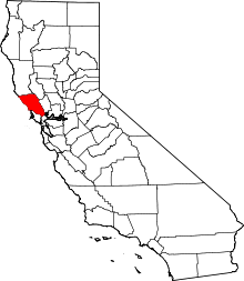
| County | Sonoma |
| Elevation | 13 ft (4 m) |
| Time zone | UTC-8 (Pacific (PST)) |
| • Summer (DST) | UTC-7 (PDT) |
| Area code(s) | 707 |
| GNIS feature ID | 252789[1] |
Schellville is an unincorporated community in Sonoma County, California, United States. Schellville is located in the vicinity of the junction of California State Route 12 and California State Route 121 south of Sonoma. The community had a post office from 1888 to 1931.[2]
The Northwestern Pacific Railroad freight and train yard is located at the Schellville Depot at California State Routes 12/121 and Eighth Street East. Service along the mainline was planned to start again in July 2010, from the California Northern interchange at Schellville, north to Windsor until delays pushed the start date to 2011.[3]
Until it ended in 2014,[4] Valley of the Moon Commute Club operated a once-daily transbay express service to San Francisco via Schellville, Sonoma, El Verano, Boyes Hot Springs, Santa Rosa, and San Rafael.
References
- ↑ "US Board on Geographic Names". United States Geological Survey. 2007-10-25. Retrieved 2008-01-31.
- ↑ Durham, David L. (1998). California's Geographic Names: A Gazetteer of Historic and Modern Names of the State. Quill Driver Books. p. 700. ISBN 1-884995-14-4.
- ↑ Brown, Matt (20 May 2014). "SMART leaves businesses out of loop". The Press Democrat. Retrieved 5 June 2017.
- ↑ http://www.sonomanews.com/csp/mediapool/sites/SIT/News/story.csp?cid=3388573&sid=744&fid=181
External links