Port River Expressway
| Port River Expressway South Australia | |
|---|---|
| General information | |
| Type | Freeway |
| Location | Adelaide |
| Length | 5.5 km (3.4 mi) |
| Opened |
|
| Built by |
|
| Maintained by | Department of Planning, Transport and Infrastructure |
| Route number(s) |
|
| Major junctions | |
| East end |
|
| |
| West end |
via Tom 'Diver' Derrick Bridge |
| Location(s) | |
| LGA(s) | City of Port Adelaide Enfield |
| Major suburbs | Wingfield, Gillman, Port Adelaide & Birkenhead |
| Restrictions | |
| General | Tom 'Diver' Derrick Bridge |
| Highway system | |
The Port River Expressway is a 5.5-kilometre (3.4 mi) freeway-grade road. The expressway links Port Adelaide and the LeFevre Peninsula to the northern suburbs of Adelaide and major interstate routes via Salisbury Highway (A13) to Port Wakefield Road (A1) and the Max Fatchen Expressway (M20) to Perth, Darwin and Sydney.
The expressway is only freeway grade at the North-South Motorway, Hanson Road and Eastern Parade interchanges; the following two intersections are at grade with traffic signals installed. This has led to the route being labelled as the A9, instead of the more common M label associated with freeways and expressways in South Australia.
Construction
The Port River Expressway was built in three stages:
- Stage 1 - Was opened for traffic on 19 July 2005. It consists of a 5.5-kilometre (3.4 mi) four-lane expressway link between Francis Street and the then South Road, Adelaide, now North-South Motorway; with an overpass at each of the junctions of the North-South Motorway, Hanson Road and Eastern Parade.[1]
- Stage 2 - Consists of a four lane high-level, opening road bridge across the Port River between Docks 1 and 2, linking Stage 1 at Francis Street to Victoria Road on Le Fevre Peninsula. This section opened on 3 August 2008[2]
- Stage 3 - Consists of a single track, dual gauge, high-level, opening rail bridge across the Port River, north of the road bridge, with connections to the existing rail system. Opened in June 2008.[3]
The Port River Expressway is now a major thoroughfare for freight and passenger road traffic travelling from the northern suburbs to the major port facilities of South Australia in Port Adelaide and Outer Harbor. The construction of Stages 2 and 3 was carried out by Abigroup.[4]
Cycling
As there is no parallel shared path near most of the Expressway and Salisbury Highway west of Port Wakefield Road, cycling is permitted on the road, except for restrictions due to closed road shoulders during construction of the Northern Connector from 2017 to 2019.[5][6] Parts of the detour route were new shared paths constructed or upgraded in anticipation of this detour.[7] The bridge over the Port River includes a shared path on the southern side of the road as part of the construction.[8]
At the time of designing Stage 1 of the Expressway, the developers did not imagine that there would be much requirement for people to cycle along it, as Mawson Lakes had not been developed for housing yet, so the Port River Expressway was seen as only connecting industries to other industries.[9]
A new path parallel to the Port River Expressway will be built as part of the Northern Connector works. This will complete a shared cycling and walking track between Gawler and Port Adelaide by the end of 2019. As a result, cycling will then be banned on the Port River Expressway itself.[10]
Exits and interchanges
The entire road is in the City of Port Adelaide Enfield local government area.
| Location | km | mi | Destinations | Notes | |
|---|---|---|---|---|---|
| Birkenhead | 0 | 0.0 | Western expressway terminus at traffic lights: continues as Victoria Road | ||
| Port River | 0.5 | 0.31 | Tom 'Diver' Derrick Bridge | ||
| Port Adelaide | 1.0 | 0.62 | Perkins Drive | Traffic light intersection | |
| Port Adelaide–Gillman boundary | 1.7 | 1.1 | Eastern Parade –North Arm, Torrens Island, Ottoway | ||
| Dry Creek–Wingfield boundary | 4.0 | 2.5 | Hanson Road – Ottoway, Wingfield Waste & Recycling Centre | ||
| 5.5 | 3.4 | Eastern expressway ends at trumpet interchange continues as Salisbury Highway. Interchange will be rebuilt in 2018–19 for Northern Connector as part of North–South Corridor | |||
| 1.000 mi = 1.609 km; 1.000 km = 0.621 mi | |||||
Gallery
 Port River Expressway approaching the South Road exit (before North-South Motorway)
 Port River Expressway approaching the Eastern Parade overpass heading east.
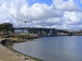 Tom Diver Derrick Bridge over the Port River.
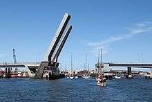 The Mary MacKillop rail bridge, adjacent to the Tom "Diver" Derrick road bridge.
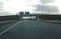
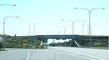 Intersection with South Road (before North-South Motorway)
See also
References
- ↑ "Stage 1 of the Port River Expressway". South Australian Department of Transport, Energy and Infrastructure. 2006-02-24. Archived from the original on 2006-08-25. Retrieved 2007-02-04.
- ↑ "Stage 2 of the Port River Expressway". South Australian Department of Transport, Energy and Infrastructure. 17 August 2007. Archived from the original on 21 December 2007. Retrieved 3 August 2008.
- ↑ "Stage 3 of the Port River Expressway". South Australian Department of Transport, Energy and Infrastructure. 17 August 2007. Archived from the original on 21 December 2007. Retrieved 25 May 2008.
- ↑ "Port River Expressway, Adelaide, Australia". Retrieved 2011-11-27.
- ↑ "Port River Expressway cycle path detour". Department of Planning, Transport and Infrastructure, Government of South Australia. 5 May 2017. Retrieved 16 January 2018.
- ↑ "Port River Expressway cycle path detour Opening - 12 noon Saturday 2 September 2017". Department of Planning, Transport and Infrastructure, Government of South Australia. September 2017. Retrieved 2011-11-27.
- ↑ "Port Wakefield Road and Salisbury Highway Cycle path detour upgrade works – commencing Monday 17 July 2017". Department of Planning, Transport and Infrastructure, Government of South Australia. July 2017. Retrieved 16 January 2018.
- ↑ "Port River Expressway" (PDF). Department for Transport, Energy and Infrastructure. October 2005. Retrieved 16 January 2018.
- ↑ "Port River Expressway Environmental Report Supplement" (PDF). Department of Transport, Environment and Infrastructure, Government of South Australia. July 2001. pp. 58–59. Retrieved 16 January 2018.
The Port River Expressway lies in a corridor that links predominantly industrial areas to industries in the Outer Harbor area (its principal purpose being to link national roads with the industrial areas of Wingfield, Enfield and Gillman). This means that bicycle paths provided in the shoulders of the Port River Expressway are not likely to be used primarily for commuting.
- ↑ Pisani, Ashleigh (26 September 2018). "Dedicated cycling and walking track planned to connect Gawler to Port Adelaide". Northern Weekly Messenger. Retrieved 4 October 2018.