Transport in Adelaide
The metropolitan area of Adelaide, South Australia is served by a wide variety of transport. Being centrally located on the Australian mainland, it forms a hub for east-west and north-south routes. The road network includes major expressways such as the Southern Expressway, the South Eastern Freeway, the Port River Expressway, the Northern Expressway and the South Road Superway. The city also has a public transport system managed by Adelaide Metro, consisting of a contracted bus system including the O-Bahn Busway (a guided busway), six metropolitan railway lines, and the Glenelg-Adelaide-Hindmarsh Tram. According to a study conducted by the Australian Bureau of Statistics, Adelaide has the highest passenger vehicle travel to work (84%) and the second lowest proportion of people walking to work (2.9%)–something that is being combated by the South Australian government in an effort to increase citizen ridership and use of public transport.[1]
Roads
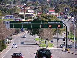
Road transport in Adelaide has historically been comparatively easier than many of the other Australian cities, with a well-defined city layout and wide multiple-lane roads from the beginning of its development. Adelaide has been called a "twenty-minute city",[2] with commuters having been able to travel from metropolitan outskirts to the city proper in twenty minutes or less. However, the Royal Automobile Association now considers these roads are inadequate to cope with Adelaide's growing road traffic volumes.[3]
In 1964 the 'M.A.T.S.' plan (Metropolitan Adelaide Transport Study) was commissioned by the Government of South Australia. It examined establishing a large network of highways along Adelaide's main urban transport corridors. The plan went as far as the State Government of the day purchasing land along Adelaide's major roads, in preparation for highway construction. However, later State Governments abandoned the plan during the 1970s. The consequences of the political rejection of this plan are now being realised as increased traffic has caused travel times to increase, and congestion on main thoroughfares such as South Road has become a daily reality.[4]
Adelaide is connected to Port Wakefield Road and the Sturt Highway in the north, and the South Eastern Freeway in the South East.[5] The Southern Expressway acts as a bypass for congested South Road in the southern suburbs of Adelaide.
Bus
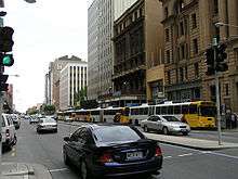
The focus of Adelaide's public transport system is the large fleet of diesel and natural gas powered buses. The majority of services terminate at the city-centre or at a suburban interchange. Buses get priority on many roads and intersections, with dedicated bus lanes and 'B'-light bus-only phases at many traffic lights.
The Adelaide Metro buses are operated by:[6]
- Torrens Transit - East-West contract area (includes City Free)
- SouthLink - Outer South, Outer North and Hills contract areas.
- Light-City Buses - North-South and Outer North East contract areas (includes the 300 suburban connector and O-Bahn services).
The O-Bahn Busway is one of a few guided busways in the world. With large growth in the North-eastern Suburbs of Adelaide in the 1970s and 1980s, when Adelaide was faced with a transport dilemma. The Adelaide O-Bahn was constructed in 1986 in response, after beating competing proposals of expanded rail and road networks. (One of the competing proposals was to build an Adelaide underground transport system, but proved to be cost-ineffective in comparison).[7]
Interstate bus routes to and from all the major Australian towns and cities connect to Adelaide. The main terminus for intra and interstate coach-liners is the Franklin Street Coach Terminal at Franklin and Bowen Streets in the city-centre. Beginning in 2005, the terminal is to undergo a complete $25 million reconstruction, in conjunction with the much larger $375 million former Balfours site redevelopment – the end-product being a new multistorey bus station and various residential and commercial towers.[8]
The Tindo ("Tindo", Kaurna word for sun) solar bus is an experimental battery electric vehicle that operates in Adelaide. It uses 100% solar power, is equipped with a regenerative braking system and air conditioning and can carry up to 40 persons,[9] 25 of whom are seated. Hailed as the world's first bus service powered exclusively by solar power, the bus service connects Adelaide City and North Adelaide as part of Adelaide City's sustainable transport agenda. The Tindo is part of Adelaide's Free bus services, operated under the call signs, 98A and 98C (until very recently known as the Adelaide Connector bus service).[10][11] Other Free services in Adelaide include the City Loop, operating under callsigns 99C and 99A, formerly known as 99C only. The 99B, the Beeline, was another free service which ran until 2007, when the Glenelg Tram line extension was finally inaugurated.
97A and 97C are new services which started when the new Royal Adelaide Hospital opened. It connects the old one with the new one. Its route includes North Terrace, Currie and Grenfell Streets. [12] The service will end once the new tram tracks are in place.
Rail
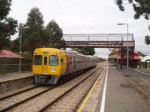
While Adelaide's suburban passenger-rail network does not suffer the chronic delays of its inter-state counterparts, it is comparatively under-developed; Adelaide is the last mainland capital with a non-electric network, with a 10-year $2 billion transport program commencing in 2008-09 to rebuild and electrify the network.[13] Adelaide is also the midpoint of the long distance Indian Pacific service between Perth and Sydney, as well as the terminus of The Overland to Melbourne and The Ghan to Alice Springs and Darwin.
In 1968, a rapid transit metro system was proposed in Adelaide underneath King William Street along with a series of freeways, however it was scrapped due to public protest about the "Americanisation" of the city.[14] As part of the sweeping Metropolitan Adelaide Transport Study plan of 1968, the subway would have included three underground rapid train stations, including one at Hindley Street, with a shopping centre on the level between the street and the rail line.
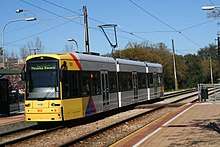
In late 2005 the State Government released a State Infrastructure Plan.[15] This saw a A$56 million upgrade of the Adelaide's sole remaining tramway, from the city centre to the historic beachside resort of Glenelg. The tram line was extended from the city centre to the railway station ( and then to new terminus in the inner north-west suburb of Hindmarsh). They are building a new track which will run in the opposite direction, from King William to the eastern end of North Terrace. There are now fifteen Flexity Classic Light Rail vehicles and six Alstom Citadis (model 302) in service with the older H-type trams being used only for special and tourist-oriented occasions.[16]
Present works to extend the line along the eastern end of North Terrace to service the South Australian Museum, University of Adelaide and old RAH redevelopment are currently delayed mid-construction.[17][18]
Air
The Adelaide Airport, located at West Beach, is Australia's newest and most advanced airport terminal and is designed to serve in excess of 6.8 million passengers annually. The new dual international/domestic terminal replaced the old and ageing terminals known locally as the 'tin sheds', and incorporates new state-of-the-art features, such as glass aerobridges and the ability to cater for the new Airbus A380. The airport is designed to handle 27 aircraft simultaneously and it is capable of processing 3,000 passengers per hour. It was officially opened in a ceremony in October 2005 by Governor Marjorie Jackson-Nelson, Premier Mike Rann and Prime Minister John Howard.[19] Due to problems with the new refuelling system, the new airport terminal was not used for interstate domestic flights until 17 February 2006.[20]
Parafield Airport is Adelaide's second airport, mostly used for general aviation. It is located 18 kilometres north of the CBD. RAAF Base Edinburgh is located 25 km north of the Adelaide CBD.
Adelaide Public Transportation Statistics
The average amount of time people spend commuting with public transit in Adelaide, for example to and from work, on a weekday is 65 min. 20.6% of public transit riders, ride for more than 2 hours every day. The average amount of time people wait at a stop or station for public transit is 11 min, while 13.4% of riders wait for over 20 minutes on average every day. The average distance people usually ride in a single trip with public transit is 8 km, while 15% travel for over 12 km in a single direction. [21]
See also
Adelaide
South Australia
Superseded Transport Authorities
Australia
References
- ↑ "Australian Social Trends". Australian Bureau of Statistics. 20 July 2013. Retrieved 6 April 2016.
- ↑ Cervero, Robert (1998). The Transit Metropolis: A Global Inquiry. Island Press. p. 363. ISBN 1559635916.
- ↑ "Metro Malcontent - The Twenty Minute City No More" (PDF). RAA. Archived from the original (PDF) on 15 January 2009.
- ↑ "RAA's Vision: Backwater to Benchmark". RAA.
- ↑ "Princes Highway SA (South-Eastern Freeway)". Ozroads.
- ↑ Minister for Transport - Report on the Adelaide Metro Bus Service Contracts, August 2011, retrieved 2011-12-03.
- ↑ "Adelaide Metro: The Adelaide O-Bahn, courtesy Adelaide Metro". Adelaide Metro.
- ↑ "Adelaide's new Bus Terminal". Capital City Committee. Archived from the original on 26 April 2006.
- ↑ To, Kien; Fernández, John E. (18–20 June 2012). "Alternative urban technologies demonstration projects for innovative cities". Third International Engineering Systems Symposium, CESUN 2012, Delft University of Technology.
- ↑ "All-Electric, Solar-Powered, Free Bus!!!". Ecogeek.org. 27 December 2007. Archived from the original on 8 September 2009. Retrieved 12 January 2013.
- ↑ "Archived copy". Archived from the original on 22 December 2015. Retrieved 16 October 2015.
- ↑ https://www.premier.sa.gov.au/index.php/stephen-mullighan-news-releases/7879-new-public-transport-arrangements-to-service-the-new-royal-adelaide-hospital
- ↑ "AdelaideNow... State Budget 08 - Foley unveils $10bn infrastructure masterplan". www.news.com.au. Archived from the original on 6 June 2008. Retrieved 5 June 2008.
- ↑ "On Paper: Exhibition showcases proposals for Adelaide that never were". ABC Online. 11 October 2015. Retrieved 14 October 2015.
- ↑ "South Australia Transport Plan". South Australian Department of Transport. Archived from the original on 20 August 2006.
- ↑ "Adelaide Metro: New Trams". Adelaide Metro.
- ↑ Maclennan, Leah; Prosser, Candice (23 July 2018). "Adelaide's North Terrace tramline extension delayed by mystery signalling issue". ABC News. Australian Broadcasting Corporation. Retrieved 28 July 2018.
- ↑ Maclennan, Leah (6 August 2018). "South Australian construction and civil engineering firm York Civil goes into administration". ABC News. Australian Broadcasting Corporation. Retrieved 7 August 2018.
- ↑ "Adelaide Airport". Adelaide Airport Limited.
- ↑ "Passengers urged to be patient as new SA terminal opens". ABC News.
- ↑ "Adelaide Public Transportation Statistics". Global Public Transit Index by Moovit. Retrieved August 23, 2017.
