Salisbury, South Australia
| Salisbury Adelaide, South Australia | |||||||||||||||
|---|---|---|---|---|---|---|---|---|---|---|---|---|---|---|---|
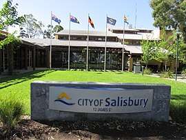 City of Salisbury council chambers | |||||||||||||||
| Population | 7,551 (2011 census)[1] | ||||||||||||||
| Established | 1843 | ||||||||||||||
| Postcode(s) | 5108 | ||||||||||||||
| Location | 25 km (16 mi) from Adelaide | ||||||||||||||
| LGA(s) | City of Salisbury | ||||||||||||||
| State electorate(s) | Ramsay, Wright, Little Para, Taylor | ||||||||||||||
| Federal Division(s) | Wakefield, Port Adelaide, Makin | ||||||||||||||
| |||||||||||||||
Salisbury /ˈsɔːlzbəri/ is a northern suburb in Adelaide, South Australia. It is the seat of the City of Salisbury, and in the South Australian Legislative Assembly electoral district of Ramsay and the Australian House of Representatives divisions of Wakefield and Port Adelaide. The suburb is a service area for the City of Salisbury district, with an abundance of parklands, shops, cafes and restaurants. Parabanks Shopping Centre is also located in Salisbury, which includes Woolworths, Coles and Big W as its signature retailers..
History
Salisbury was founded when John Harvey began selling town allotments in 1848, from land he had purchased along the Little Para River in the previous year. The town was named after Salisbury in the United Kingdom which was close to his wife's hometown.[2] There is a Wiltshire Street near Park Terrace in the city centre, parallel to John Street. Salisbury started its life as a service centre for the surrounding wheat and hay farms.[3] Salisbury Post Office opened around March 1850.[4]
Salisbury railway station was built in 1857, and is where the standard gauge line to Crystal Brook diverges from the broad gauge line to Gawler. Until the 1980s, this line was broad gauge.. In 1985 Salisbury station was rebuilt as a major STA bus/rail interchange. This was the second purpose-built transport interchange in the Adelaide metropolitan area (the first had been at Noarlunga Centre).
Salisbury grew slowly (from a population of 400-500 in 1881) until 1940 when the establishment of an explosives and filling factory doubled the population almost overnight. The factory, which covered around 11.6 km² (4.5 mi²), was in production by mid 1942 and by January 1943 employed 6,500 persons producing 135,000 shells, bombs and mines weekly.[5]
Two South Australian Australian Labor Party leaders, Lynn Arnold (Premier 1992-1993) and Mike Rann (Premier 2002-2011) both represented the Salisbury area in the South Australian Parliament. Arnold was elected as the MP for Ramsay, and then Taylor, and Rann was elected as the MP for Briggs and Ramsay.
Transport
Trains to and from Adelaide and Gawler from Salisbury operate every 15 minutes at off-peak times on Monday to Friday, and every 30 minutes during the day on Saturday and Sunday. In the evening, services run every hour. In morning peak hours, there are several trains that run non-stop between Salisbury and Adelaide (or make only one stop, at Mawson Interchange). These are used by a significant number of city workers who either park their vehicle or transfer from buses at Salisbury Interchange.
Local buses from Salisbury Interchange, scheduled to connect with trains to and from Adelaide, use the Adelaide Metro integrated ticketing system. In May 2012 there are 13 local bus routes providing links to many of the northern suburbs, such as routes 400 and 430 to Elizabeth, route 415V to Golden Grove, routes 224, 225, 411 to Mawson Lakes, routes 225, 500, 502, 560 to Para Hills, routes 401, 411 to Paralowie and routes 404, 405 to Parafield Gardens.
Retail
The major retail zone in Salisbury is the Parabanks Shopping Centre, which is a short distance from Salisbury Interchange, and was first opened around 1977. The single-floor complex includes 74 stores and 3 anchor stores[6], with a total floor area of 23,800 m2, and around 1,400 parking spaces. In April 2008, property group Stockland sold the shopping centre to the Angaet Group. In 2015, an $18 million redevelopment of the centre was approved by the Salisbury Council's Development Assessment Panel.[7] The redevelopment consisted of three stages, with five specialty stores added to the eastern side mall, the relocation of the Coles supermarket into the site of the former Harris Scarfe store, and external upgrades which were completed in October 2017.[8][9]
Gallery
.jpg) City Centre, 2007
City Centre, 2007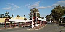 Salisbury Interchange
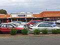 Parabanks Shopping Centre
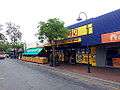 John Street
 Cemetery
See also
| Wikimedia Commons has media related to Salisbury, South Australia. |
References
- ↑ Australian Bureau of Statistics (31 October 2012). "Salisbury". 2011 Census QuickStats. Retrieved 9 April 2016.

- ↑ "Our History". City of Salisbury. Retrieved 7 March 2014.
- ↑ A City of Salisbury Publication, ed. (1985). Settlers on the Hill, A Local History of Para Hills. City of Salisbury, South Australia. p. 6.
- ↑ Premier Postal History. "Post Office List". Premier Postal Auctions. Retrieved 26 May 2011.
- ↑ Andews, F.Brian (2006). "The Salisbury Munitions Tramways". Salisbury & District Historical Society. Archived from the original on 31 August 2006. Retrieved 15 July 2006.
- ↑ User, Super. "Centre Directory | Parabanks Shopping Centre South Australia". www.parabanks.com.au. Retrieved 2017-10-18.
- ↑ "$18 million upgrade approved for Parabanks shopping centre in Salisbury". The Advertiser. 7 May 2015. Retrieved 5 November 2015.
- ↑ "Centre Redevelopment".
- ↑ User, Super. "Centre Redevelopment|Parabanks | Parabanks Shopping Centre South Australia". www.parabanks.com.au. Retrieved 2017-10-18.
Coordinates: 34°45′50″S 138°38′32″E / 34.76391°S 138.64228°E