North–South Motorway
| North–South Motorway South Australia | |
|---|---|
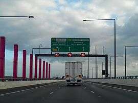 | |
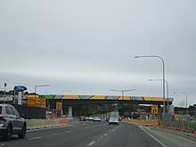
| Signage at the interchange of the M2 North South Motorway/A9 Port River Expressway/A13 Salisbury Highway. | |
| General information | |
| Type | Motorway |
| Route number(s) |
|
| Major junctions | |
| Highway system | |
The North–South Motorway is an incomplete planned motorway traversing the inner western suburbs of Adelaide from Wingfield in the north to Bedford Park in the south. It is planned to be a non-stop north–south route overlaying the same motor traffic corridor as South Road by grade separation. The motorway is to be the central section of Adelaide's North–South Corridor, being flanked north and south by the Northern Expressway (including the Northern Connector under construction) and Southern Expressway, respectively.
The Australian Government, through the Nation Building Program project, committed $500 million and the South Australian Government $432 million to the North–South Corridor over five years. This funding allocation recognised that South Road is the only continuous link between the northern and southern suburbs as well as the spine connecting Adelaide's major inter-modal transport hubs – Adelaide Airport, Islington Rail Terminal, Port Adelaide and Outer Harbor.[2]
Sections
The planned motorway is divided into several sections for the purposes of construction. As of October 2018, two sections are complete and one is under construction. From north to south the sections are labelled:
| Section | Status | Opened |
|---|---|---|
| South Road Superway | Complete | 13 March 2014 |
| Regency Road to Pym Street | Funded | planned 2022 |
| Torrens Road to River Torrens | Complete | 29 September 2018 |
| River Torrens to Anzac Highway | Unfunded | |
| Anzac Highway to Darlington | Unfunded | |
| Darlington Interchange | Under construction | planned 2019 |
South Road Superway
The South Road Superway is an elevated motorway in the northern suburbs of the South Australian capital city of Adelaide.[1] The 2.8 km elevated roadway rises just north of Taminga Street, Regency Park and goes over Days Road, before access ramps at Grand Junction Road, then continues over Cormack Road and the Dry Creek railway line to join the intersection of the Port River Expressway, Salisbury Highway and in the future, the Northern Connector. In 2009, an announcement was made to build an $812-million elevated roadway above South Road from just north of Regency Road to the end of South Road where it joins to the Port River Expressway and Salisbury Highway. It was constructed over a 4 km section of South Road at a cost of A$812 million and opened 13 March 2014. The Superway was the biggest single investment in a road project in South Australia's history.[3] The Superway was the second stage of the North–South Corridor upgrade and delivered a 4.8 kilometre section of freeway grade road, including a 2.8 kilometre elevated roadway, from the Port River Expressway to Regency Road. Along the way, it passes over the Dry Creek-Port Adelaide railway line, Cormack Road, Grand Junction Road and Days Road, with exits at Grand Junction Road and Days Road. The Superway will continue northwards through the Dry Creek salt pans once the Northern Connector is completed at its northern end.
Construction
South Australian civil engineering and construction company, Bardavcol, was awarded the early works local roads contract for the South Road Superway, with the design and construction contract awarded to Urban Superway Joint Venture, comprising the John Holland Group, Macmahon Contractors and Leed Engineering & Construction.[4]
Construction of the local connector roads was completed in early 2011, with the completion of construction of Gallipoli Drive. This road replaced South Road as the main distributor road in the area during construction. Construction of the superway proper commenced in early 2011.[5] Construction was completed March 2014. The southbound lanes opened early February 2014, with the left turn entry from Port River Expressway opening on 31 January 2014.[6] The northbound lanes opened on 13 March 2014.[7]
Regency Road to Pym Street
Connecting the South Road Superway to the Torrens Road to River Torrens lowered motorway, this short section of road currently has two traffic light intersections (including Regency Road), a controlled pedestrian crossing, and access to local side streets. It was reported in May 2017 that completion of this section would cost $400 million, with construction beginning at the start of 2019 and completed by the middle of 2022. This would complete 47 km of freeway from Gawler to the River Torrens. The state government said it was seeking 85% of the cost to be funded by the federal government, which had not committed to the spend.[8] Completion of this section was committed by the state and federal governments on 1 May 2018. The announcement stated that the cost would be A$354m but did not state an expected completion date. It will include an overpass of Regency Road and a pedestrian and cycling connection over the freeway near Pym Street. There will be three lanes each way on the non-stop road and another two lanes each way on the surface road to provide access to community and businesses.[9]
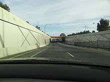
Torrens Road to River Torrens
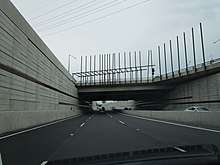
Around 2007, there were plans to construct a tunnel under Grange Road, Port Road and the Outer Harbor railway line, and construction was to start after the underpass had finished, but these plans were later scrapped. In 2013 the State Labor government in partnership with the Federal Labor government announced the Torrens Road to River Torrens Project (T2T) to upgrade approximately 4 km of road between Torrens Road and the River Torrens. The upgrade would feature a new, lowered road under Grange and Port Roads to provide a non-stop route through the area for north–south traffic and reduce delays to east-west travel, a parallel surface road along the length of the lowered road to connect the majority of local roads and arterial roads to South Road and a rail overpass of South Road for the Outer Harbor line. Construction started in 2015, with the project expected to be completed by the end of 2018.[10][11]
The project scope was extended in December 2015 to include an underpass of Torrens Road, at no additional project cost or time.[12] The lowered motorway opened to traffic on 29 September 2018.[13][14][15]
River Torrens to Anzac Highway
As of October 2018 no funding has been allocated to construction of the Torrens to Anzac Highway portion of the planned road corridor. This section includes intersections with Henley Beach Road and Sir Donald Bradman Drive. In 2018, the possibility was raised that this section could be completed by tunnelling under the existing alignment due to the tight spaces between expensive and heritage listed properties.[16]
Anzac Highway to Darlington
Although the Anzac Highway to Darlington portion of the road corridor is intended to be upgraded to include non-stop north–south traffic flow before 2030, As of October 2018 there are no detailed plans and no funding has been allocated to construction.[17] Issues with this section include the intersection of South and Daws Roads in St Marys and the 5 intersections within less than a kilometre around Castle Plaza in Edwardstown. The Gallipoli Underpass at Anzac Highway, which is only considered an interim solution, and the grade separated junction at Cross Road, including the Seaford railway line, are anticipated to be upgraded separately in advance of the rest of this section of road.[18]:16
In August 2018, the possibility was raised that this section could be completed by tunnelling under the existing alignment.[16]
Gallipoli Underpass
In 2005, along with the decision to make a free flowing South Road, a decision was made to build an underpass for South Road to go under Anzac Highway. Construction of this started in 2007, and it was named the Gallipoli Underpass, in line with the ANZAC theme. The underpass opened in March 2009, and to cut down on delays due to construction, an overpass was also built within the same time frame for the Glenelg Tram line just half a kilometre to the south, which also opened in 2009, significantly removing delays from this area.
Emerson Overpass
Between 1982 and 1984, an overpass was built at Emerson Crossing, taking South Road over Cross Road and the Seaford railway line. For a long time, this was the only grade separation on South Road, and one of very few in South Australia, removing congestion with Cross Road traffic and the railway line. Increasing frequency of commuter trains are resulting in vehicle bottlenecks that are anticipated to worsen as queues on the exit ramps to Cross Road can extend into the through lanes on South Road. The rail crossing could be closed for up to 20 minutes in the peak hour.[18]:54
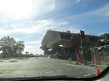
Darlington Interchange
In 2010, it was announced that an interchange would be built in Darlington, to provide better access to the Southern Expressway, as well as Flinders Medical Centre, Sturt Road and Ayliffes Road. The project was scrapped in 2011 due to budget issues, but was later revived in 2014;[19] early works commenced late in 2014 for an expected completion in 2018.[20]
A joint venture ("Gateway South") of Fulton Hogan and Laing O'Rourke was awarded the major works contract for the project in January 2016. The scope was expanded from earlier plans and will now upgrade 3.3 kilometres (2.1 mi) of Main South Road by creating a lowered non-stop road with surface-level service roads. There will be three lanes each way connecting from the Southern Expressway and the lowered road, which will pass underneath Flinders Drive (access to Flinders University and Flinders Medical Centre), Sturt Road, a bridge connecting Mimosa Terrace (Clovelly Park) and Sutton Road (Bedford Park) mainly for local traffic, grade separation at the Ayliffes Road and Shepherds Hill Road junction, and at Tonsley Boulevard. It will also provide separate cycling and pedestrian paths on each side of the corridor. The associated Flinders Link Project will extend the Tonsley railway line across this corridor to Flinders Medical Centre.[21]
Exits and interchanges
South Road Superway
| LGA | Location | km | mi | Destinations | Notes |
|---|---|---|---|---|---|
| Port Adelaide Enfield | Wingfield | 0 | 0.0 | Northern terminus: continues as | |
| 1.9 | 1.2 | Southbound exit, Northbound entry only | |||
| Regency Park | 3.4 | 2.1 | South Road – Regency Park | Northbound exit, southbound entry only | |
| 4.8 | 3.0 | Southern terminus: continues as | |||
| |||||
Torrens Road to River Torrens
| LGA | Location | km | mi | Destinations | Notes |
|---|---|---|---|---|---|
| Port Adelaide Enfield | Croydon Park | South Road | North–South Motorway is below-grade, between the carriageways of unnumbered South Road at ground level. Continues north as | ||
| Charles Sturt | Croydon, Ridleyton | Northbound entrance, southbound exit leading from/to Port Road intersection only | |||
| Ridleyton, Croydon, Hindmarsh | Outer Harbor railway line | ||||
| Hindmarsh, West Hindmarsh | South Road | North–South Motorway is below-grade, between the carriageways of unnumbered South Road at ground level. Continues south as | |||
| |||||
See also
![]()
References
- 1 2 Department of Planning, Transport and Infrastructure (13 March 2014). "Use the South Road Superway and save time: Northbound lanes to open on Thursday night" (PDF). Media Release. Government of South Australia. Archived (PDF) from the original on 7 May 2014. Retrieved 7 May 2014.
- ↑ Australian Government (26 June 2010). "Nation Building - Economic Stimulus Plan". Retrieved 26 June 2010.
- ↑ Infrastructure SA (21 May 2010). "South Road Superway: Demography". Retrieved 26 June 2010.
- ↑ Infrastructure SA (30 April 2010). "Project Overview: Demography". Retrieved 29 June 2010.
- ↑ Infrastructure SA (30 April 2010). "Project official webpage". Retrieved 29 June 2010.
- ↑ Infrastructure SA (30 April 2010). "Project official webpage". Retrieved 2 February 2014.
- ↑ "South Road Superway". Department of Planning, Transport and Infrastructure. 14 March 2014. Retrieved 1 September 2014.
- ↑ Wills, Daniel (15 May 2017). "South Rd upgrade: Construction to start between Regency Rd and Pym St". The Advertiser. Retrieved 28 February 2018.
- ↑ "Regency Road to Pym Street". Department of Planning, Transport and Infrastructure. Retrieved 30 April 2018.
- ↑ "North-South Corridor: Torrens Road to River Torrens". Department of Planning, Transport and Infrastructure, Government of South Australia. 5 August 2015. 145594. Retrieved 8 August 2015.
- ↑ "T2T". T2T Alliance. 31 July 2015. Retrieved 8 August 2015.
- ↑ "Torrens Road to Torrens River Project Scope Extension". Department of Planning, Transport and Infrastructure. Retrieved 12 December 2015.
- ↑ "Torrens to Torrens Part of South Road Upgrade to Open This Weekend". AdelaideNow. Retrieved 1 October 2018.
- ↑ "TORRENS ROAD TO RIVER TORRENS LOWERED MOTORWAY TO OPEN TO TRAFFIC" (PDF). Government of South Australia. 28 September 2018.
- ↑ "North-South Corridor open to traffic". RoadsOnline.com.au. 1 October 2018.
- 1 2 Smith, Matt (10 August 2018). "State Government puts the possibility of tunnels back on the table for North-South corridor". The Advertiser. Retrieved 3 September 2018.
- ↑ "South Road Planning (Anzac Highway to Southern Expressway)". Department of Planning, Transport and Infrastructure. Retrieved 6 April 2016.
- 1 2 "North–South Corridor The 10 year Strategy" (PDF). Department of Planning, Transport and Infrastructure. May 2015. K-Net #9526649, V1. Retrieved 6 April 2016.
- ↑ "Darlington Upgrade Project". Department of Planning, Transport and Infrastructure. 5 September 2014. Retrieved 19 December 2014.
- ↑ "What's next". Department of Planning, Transport and Infrastructure. 3 December 2014. Retrieved 19 December 2014.
- ↑ "Darlington Upgrade Project". Department of Planning, Transport and Infrastructure. Retrieved 3 September 2018.