King William Street, Adelaide
King William Street is the part of a major arterial road that traverses the CBD and centre of Adelaide (the capital of South Australia).[1] It was named by the Street Naming Committee on 23 May 1837 after King William IV, the then reigning monarch, who died within a month.[2] King William Street is approximately 40 metres (130 ft) wide, and is the widest main street of all the Australian State capital cities, which are significantly narrower by comparison. It is historically considered one of Adelaide's high streets, for its focal point of businesses, shops and other prominent establishments.
Description
The name King William is applied several times to the continuous stretch of road that begins in the inner southern suburbs and terminates in North Adelaide. Where it runs through the Adelaide city centre, it is named "King William Street"; elsewhere it is named "King William Road". It starts in the south as King William Road, at the north edge of Heywood Park in Unley Park, and runs through Hyde Park and Unley to Greenhill Road. It runs through the south parklands (as Peacock Road), the Adelaide city centre (as King William Street) and continues north from North Terrace as King William Road to Brougham Place, North Adelaide.
The road continues north to National Highway 1 as O'Connell Street, but the name King William is not again used. The northern section called King William Road (connecting the Adelaide city centre with North Adelaide) passes several of Adelaide's landmarks, including Government House, Elder Park, the Adelaide Festival Centre, Adelaide Oval and St Peter's Cathedral. The section from North Terrace over the Adelaide Bridge to Pennington Terrace was named King William Road at the opening of the bridge in 1877.[3]
Also, travelling north-south, the cross-streets alternate between being wide (up to 4-lanes wide) and narrow (2-lanes wide), with the exception that Grote and Wakefield Streets are up to 6-lanes wide. Note that in the south half of the city, in several places the Adelaide City Council has increased the widths of footpaths and changed the road markings so that traffic is restricted to use a lesser number of lanes than the full width of the road.
Before the 1960s, trams in Adelaide used King William Street as a major backbone of the network, with a full grand union junction at North Terrace and only one pair of tracks missing between Grenfell and Currie Streets.[4] When most of the tram lines were dismantled, only the Glenelg tram remained, and it used King William Street between South Terrace and its terminus in Victoria Square. In 2007, the tram line was extended to run the full length of King William Street again, turning left onto North Terrace and terminating at Adelaide railway station, later extended to Adelaide Entertainment Centre. Tram travel between South Terrace and the Entertainment Centre is free. In 2018, another expansion of the tram routes replaced the turn at the intersection of North Terrace and King William Street with a junction. Tracks go in all four directions, but not all turning movements are supported.[5]
Street name changes
Between North Terrace and South Terrace, all east-west roads change their names as they cross King William Street. It is said this is because no one was allowed to "cross the path of a monarch".[2] Travelling south from North Terrace, the street pairs are:[6]
| West Terrace ↓ | Morphett Street ↓ | King William Street ↓ | Pulteney Street ↓ | East Terrace ↓ | Designed width | ||||
|---|---|---|---|---|---|---|---|---|---|
| North Terrace |
North Terrace |
North Terrace |
North Terrace |
4-lane | |||||
| Hindley Street |
Hindley Street |
Rundle Mall |
Rundle Street |
2-lane | |||||
| Currie Street |
Light Square |
Currie Street |
Grenfell Street |
Hindmarsh Square |
Grenfell Street |
4-lane | |||
| Waymouth Street |
Waymouth Street |
Pirie Street |
Pirie Street |
2-lane | |||||
| Franklin Street |
Franklin Street |
Victoria Square |
Flinders Street |
Flinders Street |
4-lane | ||||
| Grote Street |
Grote Street |
Wakefield Street |
Wakefield Street |
6-lane | |||||
| Gouger Street |
Gouger Street |
Angas Street |
Angas Street |
4-lane | |||||
| Wright Street |
Whitmore Square |
Wright Street |
Carrington Street |
Hurtle Square |
Carrington Street |
2-lane | |||
| Sturt Street |
Sturt Street |
Halifax Street |
Halifax Street |
4-lane | |||||
| Gilbert Street |
Gilbert Street |
Gilles Street |
Gilles Street |
2-lane | |||||
| South Terrace |
South Terrace |
South Terrace |
South Terrace |
4-lane | |||||
| West Terrace | Morphett Street | King William Street | Pulteney Street | East Terrace | Designed width |
In popular culture
King William Road was referenced in the John Schumann song "Hyde Park Calling (King William Road Scene 1)" on the 1993 album True Believers.
Gallery
_opp._Beehive_Corner%2C_Cnr_King_William_%26_Rundle_Streets%2C_1866.jpg) The street (running left to right), 1867
The street (running left to right), 1867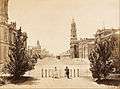 View from Victoria Square, 1870s
 C. 1869-1889. Town Hall on left, Post Office on right.
.jpg) Sometime between 1869 and 1889.
Sometime between 1869 and 1889.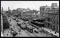 The street, 1923
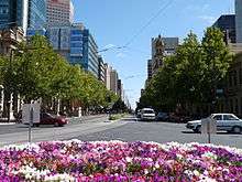
- King William Street, looking north from Victoria Square, February 2009.
.jpg) View south from Rundle Mall, 2004
View south from Rundle Mall, 2004 King William Street looking south, December 2010
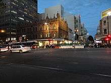 The intersection from King William Street, looking east towards Rundle Mall, 2013.
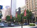 King William Street between North Terrace and Currie Street, looking south-west, November 2006.
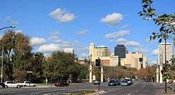
 View south from the Festival Centre
- King William Road, North Adelaide, from the Adelaide Oval, looking south over the River Torrens towards North Terrace, King William Street and the Adelaide city centre, May 2009.
.jpg) King William Street, looking north towards St Peter's Cathedral
King William Street, looking north towards St Peter's Cathedral
See also
![]()
References
- ↑ 2003 Adelaide Street Directory, 41st Edition. UBD (A Division of Universal Press Pty Ltd). 2003. ISBN 0-7319-1441-4.
- 1 2 "History of Adelaide through street names – Street Names". www.historysouthaustralia.net. Retrieved 2008-09-11.
- ↑ "OPENING OF THE ADELAIDE BRIDGE". South Australian Register. Adelaide. 17 May 1877. p. 3 Supplement: Supplement to the South Australian Register. Retrieved 9 December 2014 – via National Library of Australia.
- ↑ "Trolley Wire" (PDF). South Pacific Pacific Electric Railway Co-operative Society Limited. August 1992. p. 5. Retrieved 19 January 2018 – via Sydney Tramway Museum.
- ↑ Gailberger, Jade (22 November 2017). "Government tries explaining why Adelaide trams could turn right 100 years ago — but not now". The Advertiser. Retrieved 19 January 2018.
- ↑ Map of the Adelaide city centre, North Adelaide and the Adelaide Parklands.
Streets and squares of Adelaide city centre | |||||||||||||
|---|---|---|---|---|---|---|---|---|---|---|---|---|---|
| |||||||||||||