Franklin Street, Adelaide
| Franklin Street South Australia | |
|---|---|
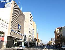 | |
| Franklin Street, looking west from King William Street | |
| General information | |
| Type | Street |
| Length | 1.1 km (0.7 mi) |
| Opened | 1837 |
| Major junctions | |
| Eastern end | King William Street, Victoria Square |
| Morphett Street | |
| Western end | West Terrace |
Franklin Street is a main street in the centre of Adelaide, South Australia.[1][2]
Franklin Street terminates at its western end at West Terrace. The eastern end merges into the northern edge of Victoria Square and continues across King William Street as Flinders Street. It is the location of the Adelaide General Post Office, the former Maughan Uniting Church, Eynesbury College, the interstate bus terminal, and various companies.
The street was named on 23 May 1837 in honour of John Franklin, Arctic explorer and Governor of Tasmania.[3]
2011 redevelopment
In 2011, the street commenced a mid-scale redevelopment of four major buildings:
- 50m 71-83 Franklin Street [Approved-2014]
- 67m 42-56 Franklin Street [Approved-2013]
- 72m City Central 8 [U/C- 2012]
- 73m 58-76 Franklin Street [U/C-2014]
Gallery
 Adelaide GPO
(General Post Office)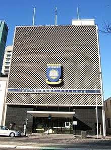 Eynesbury College
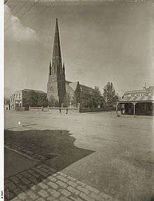 Maughan Church, 1896
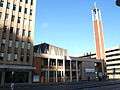 Maughan Church, 2010 (Built 1965)
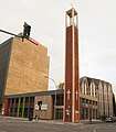 Maughan Uniting Church, 2014. Demolished in 2016.[4]
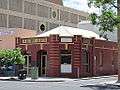 Publisher 2012 - built 1914.
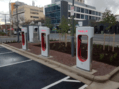
See also
![]()
References
- ↑ 2003 Adelaide Street Directory, 41st Edition. UBD (A Division of Universal Press Pty Ltd). 2003. ISBN 0-7319-1441-4.
- ↑ Map of the Adelaide CBD, North Adelaide and the Adelaide Parklands.
- ↑ History of Adelaide Through Street Names, historysouthaustralia.net
- ↑ Final pieces of gothic Maughan Church set to fall The Advertiser, 13 September 2016. Retrieved 27 May 2017.
- ↑ The first Tesla Superchargers (also with generic chargers) in South Australia, completing an Australian Tesla charging network that stretches as far as the Queensland capital over 2,000 km (1,200 mi) away Tesla charging stations to link Adelaide with world's largest battery: RenewEconomy.com.au 28 September 2017
Streets and squares of Adelaide city centre | |||||||||||||
|---|---|---|---|---|---|---|---|---|---|---|---|---|---|
| |||||||||||||
This article is issued from
Wikipedia.
The text is licensed under Creative Commons - Attribution - Sharealike.
Additional terms may apply for the media files.