Torrens Island
 Torrens Island | |
| Geography | |
|---|---|
| Location | Adelaide |
| Coordinates | 34°47′36″S 138°31′45″E / 34.793225°S 138.529276°ECoordinates: 34°47′36″S 138°31′45″E / 34.793225°S 138.529276°E[1] |
| Area | 7.69 km2 (2.97 sq mi)[1] |
| Administration | |
| South Australia | |
Torrens Island is an island in the Australian state of South Australia located in the Port River Estuary between the Port River and Barker Inlet, about 15 kilometres (9.3 mi) northwest of the state capital of Adelaide. Since European settlement of Adelaide in 1836, it has been used for a number of purposes.
Quarantine Station
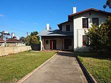
Being uninhabited, an island, adjacent to Port Adelaide, and near Outer Harbor, Torrens Island was initially used as the site of a Quarantine Station for new arrivals (by sea) to South Australia.[2] One example of its use was during the so-called "Boonah crisis".
There were two quarantine stations on the site at different times; the surviving Torrens Island Quarantine Station is listed on the South Australian Heritage Register.[3]
Tours of the heritage-listed Quarantine Station are conducted by the South Australian Maritime Museum.[4]
Internment Camp
The Torrens Island Internment Camp was a World War I detention camp which held up to 400 men of German or Austro-Hungarian background between 9 October 1914 and 16 August 1915.
Power Stations
There are two power stations on Torrens Island:
- Torrens Island Power Station, completed in 1967, and since 2007 operated by AGL Energy; capacity of 1,280 MW.[5]
- Quarantine Power Station, built and operated since 2002 by Origin Energy; original capacity 95 MW, expanded in 2009 to 216 MW.[6]
A proposed third station known as the Barker Inlet Power Station was announced in 2017 with construction commenced in the third quarter of the year with the aim to commission the new station during the first quarter of 2019,[7]
Protected area status
Torrens Island has been located within the boundaries of the following protected areas to varying extents since 1963, 1973 and 2005 respectively – the Torrens Island Conservation Park which covers all of the island down to low water with exception to the most of land associated with the former quarantine station and the land associated with the Quarantine Power Station and Torrens Island Power Stations, the Barker Inlet-St Kilda Aquatic Reserve which covers all of the east side of the island located below high water and the Adelaide Dolphin Sanctuary which overlays the entire island.[1][8][9][10][11]
Gallery
 The 1280MW Torrens Island Power Station from the Port River, Adelaide, South Australia.
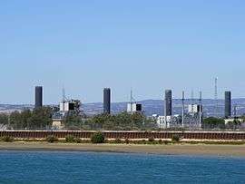 The 95MW Quarantine Power Station on Torrens Island, Adelaide, South Australia with the Port River in the foreground. This station lies between the old Quarantine Station and the larger Torrens Island Power Station.
See also
References
| Wikimedia Commons has media related to Torrens Island. |
- 1 2 3 "Search results for 'Torrens Island' with the following datasets selected – 'Suburbs and Localities', 'Dolphin Sanctuary', 'Aquatic Reserves', 'NPW and Conservation Boundaries', 'Hundreds', 'Roads', 'SA Heritage Places', 'SA Heritage Places Indicative Footprints', 'Metropolitan Adelaide Boundary (Development Act 1993)' and 'Gazetteer'". Location SA Map Viewer. South Australian Government. Retrieved 3 April 2018.
- ↑ D. Walsh:Torrens Island Quarantine Station Weekendnotes, 4 July 2013. Accessed 17 July 2013.
- ↑ "Torrens Island Quarantine Station (including Jetties, Cemetery, Mortuary & Complex)". South Australian Heritage Register. Department of Environment, Water and Natural Resources. Retrieved 12 February 2016.
- ↑ Torrens Island Quarantine Station tours SA Maritime Museum. Retrieved 11 March 2018.
- ↑ AGL takes ownership of Torrens Island power station AGL press release to ASX, 3 July 2007. Accessed 17 July 2013.
- ↑ Origin Energy > Quarantine Power Station Accessed 17 July 2013.
- ↑ Vazey, Rosanna (7 June 2017). "AGL announces development of $295 million power station in South Australia". AGL Corporate Blog (Press release). AGL. Retrieved 1 August 2017.
- ↑ "Protected Areas Information System Reserve List" (PDF). Government of South Australia. 14 December 2016. Retrieved 27 December 2017.
- ↑ Primary Industries and Regions South Australia (PIRSA) (2007), Aquatic Reserve: Barker Inlet (PDF), Primary Industries and Regions South Australia, archived from the original (PDF) on 2016-10-10
- ↑ Primary Industries and Regions South Australia (PIRSA) (2007), Aquatic Reserve: St Kilda – Chapman Creek (PDF), Primary Industries and Regions South Australia, archived from the original (PDF) on 2014-10-06
- ↑ "The Adelaide Dolphin Sanctuary". Natural Resources Management Adelaide and Mount Lofty Ranges. Retrieved 5 October 2014.
| West coast of Eyre Peninsula |
| ||||||||
|---|---|---|---|---|---|---|---|---|---|
| Spencer Gulf |
| ||||||||
| Investigator Strait | |||||||||
| Kangaroo Island |
| ||||||||
| Gulf St Vincent | |||||||||
| Backstairs Passage | |||||||||
| Encounter Bay and adjoining waters | |||||||||
| South east coast | |||||||||
| Mainland |
| ||||||||
| |||||||||