Port Wakefield, South Australia
| Port Wakefield South Australia | |||||||||||||||
|---|---|---|---|---|---|---|---|---|---|---|---|---|---|---|---|
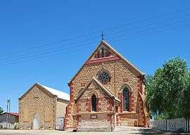 Uniting Church at Port Wakefield | |||||||||||||||
 Port Wakefield | |||||||||||||||
| Coordinates | 34°11′0″S 138°09′0″E / 34.18333°S 138.15000°ECoordinates: 34°11′0″S 138°09′0″E / 34.18333°S 138.15000°E | ||||||||||||||
| Population | 476 (2006 census)[1] | ||||||||||||||
| Postcode(s) | 5550 [2] | ||||||||||||||
| Location |
99 km (62 mi) North West of Adelaide city centre via | ||||||||||||||
| LGA(s) | Wakefield Regional Council[3] | ||||||||||||||
| State electorate(s) | Narungga[4] | ||||||||||||||
| Federal Division(s) | Wakefield[5] | ||||||||||||||
| |||||||||||||||
| Footnotes | Adjoining localities[6] | ||||||||||||||
Port Wakefield (formerly Port Henry) was the first government town to be established north of the capital, Adelaide, in South Australia.
Port Wakefield is situated 98.7 kilometres (61.3 miles) from the Adelaide city centre and lies on the Port Wakefield Road section of the A1 National Highway. Port Wakefield is situated on the River Wakefield, at the head of the Gulf St Vincent.
History
The town was originally named Port Henry by William Hill.[7] The name of the town was, around 1849, changed to Port Wakefield, after the Wakefield River.[8]
In 1848, the Patent Copper Company agreed to build and operate a smelter at Burra. Seeking to reduce cartage costs, a track was surveyed to its port established at the mouth of the River Wakefield. By securing leases of the appropriate Crown Land, the company obtained a monopoly of the port. The Government declared the track the Great Western Road. The wharf was constructed along the bank of the river and cargo was transferred between the wharf and ships at anchor in the Gulf on lighters.
With the opening of the railway from Adelaide to Gawler in 1857, the Copper Company's traffic came to a sudden end, leaving only pastoral produce to flow to the port. Mixed farming was established on lands opening up by the Government along the River in the mid-1860s and this called for improvement in transport to the Port.
William Hanson, Manager for Railways, selected a route for a horse-drawn tramway terminating at Hoyles Plains, later renamed Hoyleton. The enabling Act provided for a tramway of 28 miles 41 chains (45.9 km) in length to a gauge of 1,067 mm (3 ft 6 in), the first line in South Australia built to that gauge. Subsequently, the Government agreed that the line should be operated by a private body. The successful tenderer was one Paul Badcock who opened the line to traffic on 4 January 1870. Horses were worked in three relays between the stations on the route.
The choice of gauge was influenced by the argument that costs varied with the cube of the gauge.[9] As this railway had its own port, it was not expected to link up with any broad gauge railways which avoided of course any break of gauge problems. Following a surrender of the lease, the line was taken over by the Government at the end of 1870.
On 1 March 1876 the line was extended from Hoyleton to Blyth. Steam locomotives were subsequently obtained and, by August, 1876, the entire line was being worked by steam power. The line was extended at the other end from Port Wakefield to Kadina on 9 October 1878.
In 1927, these railways, and the remainder of the Western system that grew from them, were converted to the broad 1,600 mm (5 ft 3 in) gauge.[10]
The Wesleyan Methodist chapel was built in 1868 by a local stonemason and carpenter. It continues in use as a Uniting Church.[11]
Media
In 1876, a short lived newspaper was printed in the town, called the Port Wakefield Times and Balaclava, Hoyleton, Blyth and Lochiel Advertiser (July - August 1876)[12] and published by Edward Richardson.[13] A later newspaper was the Wakefield Sun (15 July 1910 – 31 May 1912).[14] Another publication, the Port Wakefield Monitor (7 January 1915 - 26 June 1941), was also published locally.[15][16]
Local government
On 28 November 1878 the District Council of Port Wakefield was established on the same day as the District Council of Clinton and District Council of Kulpara, bringing local government to the area.[17]
Today
Port Wakefield is a major stop on the Adelaide – Yorke Peninsula and Adelaide – Port Augusta road routes. Just north of the township there is a major forked intersection where the Yorke Peninsula traffic diverges west onto the Copper Coast Highway from the main Augusta Highway. The intersection is notorious for road accidents and traffic delays, especially at the end of holidays and long weekends.[18][19]
Located thus, Port Wakefield is known mostly for its roadhouses and trucking stops, including Shell, United, Tucker Time and BP. Travellers between Adelaide and any of the Flinders Ranges, Yorke Peninsula, Eyre Peninsula or the Nullarbor Plain will likely travel through Port Wakefield.
Port Wakefield has several adjacent beaches and caravan parks. Accommodation is available at several places in town, including the Port Wakefield Motel (located just off the highway) and the Port Wakefield Caravan Park.
See also
References
- ↑ Australian Bureau of Statistics (25 October 2007). Port Wakefield (Urban Centre/Locality). 2006 Census Quickstats. Retrieved on 2008-05-29
- ↑ Port Wakefield Postcode. Australia Post. Retrieved on 2008-05-29
- ↑ "Development Plan – Wakefield Council". Department of Planning Transport and Infrastructure. pp. 196, 239 & 248. Retrieved 24 July 2015.
- ↑ Narungga (Map). Electoral District Boundaries Commission. 2016. Retrieved 1 March 2018.
- ↑ "Federal electoral division of Wakefield" (PDF). ustralian Electoral Commission. Retrieved 23 July 2015.
- ↑ "Search result for "Port Wakefield (Locality Bounded)" (Record no. SA0040720) with the following layers selected – "Suburbs and Localities" and " Place names (gazetteer)"". Property Location Browser. Government of South Australia. Retrieved 16 November 2016.
- ↑ "Search results for "Placename Details: Port Henry" (Record Number SA0007442)". Government of South Australia. Retrieved 29 July 2015.
- ↑ "Wakefield, Port; Nomenclature". State Library of South Australia. Retrieved 29 July 2015.
- ↑ "RAILWAY GAUGES". South Australian Register. Adelaide. 9 January 1867. p. 2. Retrieved 14 August 2011.
- ↑ Callaghan, W.H. (2002). "Horse and Steam, Wheat and Copper". Australian Railway Historical Society Bulletin (January, February, 2002): 9–27, 46–63.
- ↑ "Port Wakefield Uniting Church is turning 150". Yorke Peninsula Country Times. 7 August 2018. Retrieved 8 August 2018.
- ↑ Port Wakefield times and Balaclava, Hoyleton, Blyth and Lochiel advertiser. Port Wakefield [S. Aust.] : Edward Richardson. 1876.
- ↑ Laube, Anthony. "LibGuides: SA Newspapers: O-R". guides.slsa.sa.gov.au. Retrieved 2018-03-05.
- ↑ The Wakefield sun [newspaper: microform]. Port Wakefield, S. Aust: James Barclay. 1910.
- ↑ "Newspapers in the Northern and Yorke Peninsula region South Australia". www.jaunay.com. Retrieved 2018-03-05.
- ↑ The Port Wakefield monitor [newspaper: microform]. Snowtown, S. Aust: L. F. Henstridge. 1915.
- ↑ "Proclamations" (PDF). South Australian Government Gazette (55 ed.). Government of South Australia. 1878: 1568. 28 November 1878. Retrieved 3 July 2017.
- ↑ Kelton, Sam (21 April 2014). "Two separate crashes, involving five cars, at Port Wakefield Rd intersection cause traffic pain for Easter drivers". The Advertiser. News Corp. Retrieved 11 August 2015.
- ↑ Bishop, Ian (14 October 2014). "RAA Regional Roads Assessment – Yorke Peninsula" (PDF). Royal Automobile Association. p. 6 (PDF page 11). Retrieved 11 August 2015.
The Copper Coast Highway is notorious for the extensive delays occurring at the intersection with the Augusta Highway and RAA recommends this intersection be addressed in the medium term.
External links
| Wikivoyage has a travel guide for Port Wakefield. |
| Wikimedia Commons has media related to Port Wakefield, South Australia. |