Flinders Street, Adelaide
| Flinders Street South Australia | |
|---|---|
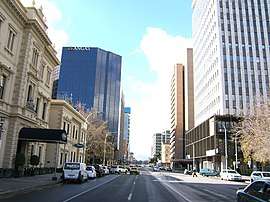 | |
| Flinders Street, looking east from King William Street | |
| General information | |
| Type | Street |
| Length | 1.2 km (0.7 mi)[1] |
| Opened | 1837 |
| Major junctions | |
| Western end | King William Street |
| Pulteney Street | |
| Eastern end | East Terrace |
Flinders Street is a main street in the city centre of Adelaide, South Australia.[2][3] It was the location of Flinders St School of Music, a campus of TAFE, but has been closed in the last decade. It is named after the navigator and cartographer Captain Matthew Flinders.
Flinders Street runs from the northern end of Victoria Square to East Terrace, Adelaide. It is one of the intermediate-width streets of the Adelaide grid, at 1 1⁄2 chains (99 ft; 30 m) wide.
Junction list
| Location | km[4] | mi | Destinations | Notes | |
|---|---|---|---|---|---|
| Adelaide city centre | 0 | 0.0 | Victoria Square, King William Street | Continues as Franklin Street | |
| 0.2 | 0.12 | Gawler Place | |||
| 0.55 | 0.34 | Pulteney Street | |||
| 0.75 | 0.47 | Frome Street | |||
| 1.1 | 0.68 | Hutt Street | Eastern side of the intersection is permanently closed to traffic | ||
| 1.2 | 0.75 | East Terrace | |||
| 1.000 mi = 1.609 km; 1.000 km = 0.621 mi | |||||
See also
![]()
References
- ↑ Google. "Flinders Street" (Map). Google Maps. Google.
- ↑ 2003 Adelaide Street Directory, 41st Edition. UBD (A Division of Universal Press Pty Ltd). 2003. ISBN 0-7319-1441-4.
- ↑ Map of the Adelaide CBD, North Adelaide and the Adelaide Parklands.
- ↑ Google (11 December 2016). "Flinders Street, Adelaide" (Map). Google Maps. Google. Retrieved 11 December 2016.
Streets and squares of Adelaide city centre | |||||||||||||
|---|---|---|---|---|---|---|---|---|---|---|---|---|---|
| |||||||||||||
This article is issued from
Wikipedia.
The text is licensed under Creative Commons - Attribution - Sharealike.
Additional terms may apply for the media files.