Port Road, Adelaide
| Port Road South Australia | |
|---|---|
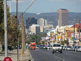 | |
| Looking towards the Adelaide city centre from Port Road in Hindmarsh | |
| General information | |
| Type | Road |
| Length | 12 km (7.5 mi) |
| Route number(s) |
|
| Former route number |
|
| Major junctions | |
| SE end | West Terrace, Adelaide |
| |
| NW end |
|
| Location(s) | |
| Major suburbs | Adelaide Park Lands, Thebarton, Hindmarsh, West Croydon, Kilkenny, Woodville South, Woodville, Woodville West, Albert Park, Cheltenham, Alberton, Port Adelaide |
Port Road (state route A7) is a major road in Adelaide, South Australia connecting the Adelaide city centre with Port Adelaide.[1] It is 12 km (7.5 mi) long and exceptionally wide, approximately 70 m. When first conceived upon the establishment of Adelaide, it was designed to be able to accommodate a standard road, a railway line and a canal. The canal and railway line were never created in the road allotment: the railway line when built in 1853 was built 1 km to the east.
In the 1968 Metropolitan Adelaide Transport Study (MATS plan) the road was destined to be upgraded to become the Port Freeway. The plan fell through, yet in 2005 the Government of South Australia announced a 600 m tunnel for South Road below Port Road and the railway line. The Torrens Road to River Torrens project to upgrade South Road to include a free-flowing road in a trench under Port Road and several other intersections started construction in 2015 and is expected to be completed by the end of 2018.[2][3]
Some routes in Adelaide were renumbered in 2017. Port Road had been designated route A21 (city ring route) between West Terrace and Park Terrace. After the change, the West Terrace end is not numbered, and it bears route R1 (city ring route) between James Congdon Drive and Park Terrace.
Major intersections
 Location of Port Road in Adelaide.
See also
![]()
References
- ↑ 2003 Adelaide Street Directory, 41st Edition. UBD (A Division of Universal Press Pty Ltd). 2003. ISBN 0-7319-1441-4.
- ↑ "North-South Corridor: Torrens Road to River Torrens". Department of Planning, Transport and Infrastructure, Government of South Australia. 5 August 2015. 145594. Retrieved 8 August 2015.
- ↑ "T2T". T2T Alliance. 31 July 2015. Retrieved 8 August 2015.
- 1 2 "Property Location Browser". Government of South Australia. Retrieved 5 March 2016.
- ↑ Google (5 March 2016). "Port Road, Adelaide to Port Adelaide" (Map). Google Maps. Google. Retrieved 5 March 2016.
- ↑ "Project Scope". T2T Alliance. Retrieved 10 January 2017.
External links
34°54′30″S 138°34′37″E / 34.908465°S 138.576819°E