Pine Plains (town), New York
| Pine Plains, New York | |
|---|---|
| Town | |
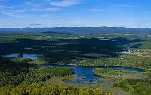 Central Pine Plains from the Stissing Mountain fire tower | |
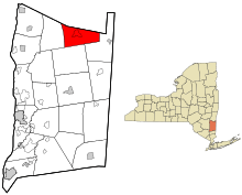 Location of Pine Plains, New York | |
| Country | United States |
| State | New York |
| County | Dutchess |
| Government | |
| • Type | Town Council |
| • Town Supervisor | Darrah Cloud (D) |
| • Town Council |
Members' List
|
| Area[1] | |
| • Total | 31.17 sq mi (80.74 km2) |
| • Land | 30.59 sq mi (79.21 km2) |
| • Water | 0.59 sq mi (1.52 km2) |
| Elevation | 474 ft (144 m) |
| Population (2010) | |
| • Total | 2,473 |
| • Estimate (2016)[2] | 2,422 |
| • Density | 79.19/sq mi (30.58/km2) |
| Time zone | Eastern (EST) |
| ZIP code | 12567 |
| FIPS code | 36-027-58156 |
| Website |
pineplains-ny |
Pine Plains is a town in Dutchess County, New York, United States. The population was 2,473 at the 2010 census.[3] The name is derived from the geographic character of the region. The hamlet of Pine Plains is on the north border of the county.
History
The town was part of the Little Nine Partners Patent of 1706. The town was first settled around 1740 by Moravian missionaries to the native Mahican village of Shekomeko. The town of Pine Plains was formed from the town of North East in 1823.
In 1907, Walter W. Law moved Briarcliff Farms from Briarcliff Manor, New York, to Pine Plains and sold the property in 1918.[4] In 1916, New York banker Oakleigh Thorne and several business partners purchased large land parcels and began breeding Angus cattle still in the name of Briarcliff Farm. The farm was broken up into several smaller farms in the late 1940s, and most lasted until the early 1980s, closing due to property taxes and poor economic conditions. Berkshire Stud purchased 550 acres (0.9 sq mi) there, starting in 1983.[5]
Geography
According to the United States Census Bureau, the town has a total area of 31.2 square miles (80.7 km2). 30.6 square miles (79.2 km2) of it is land, and 0.58 square miles (1.5 km2), or 1.89%, is water.[3] The north town line is the border of Columbia County.
Three small lakes lie west of Pine Plains hamlet: Stissing Lake which is excellent for swimming, Thompson Pond which is dedicated to conservation for wildlife, and Twin Island Lake. Stissing Mountain, the town's highest point at 1,403 feet (428 m), is immediately to the west. It is formed of Precambrian gneiss that remains after numerous cycles of glaciation have scoured and reformed the surrounding terrain.
Land use
The town recently enacted its first zoning ordinance after protracted review, discussion and community input.
Demographics
| Historical population | |||
|---|---|---|---|
| Census | Pop. | %± | |
| 1830 | 1,503 | — | |
| 1840 | 1,334 | −11.2% | |
| 1850 | 1,416 | 6.1% | |
| 1860 | 1,412 | −0.3% | |
| 1870 | 1,503 | 6.4% | |
| 1880 | 1,352 | −10.0% | |
| 1890 | 1,308 | −3.3% | |
| 1900 | 1,263 | −3.4% | |
| 1910 | 1,420 | 12.4% | |
| 1920 | 1,252 | −11.8% | |
| 1930 | 1,209 | −3.4% | |
| 1940 | 1,301 | 7.6% | |
| 1950 | 1,360 | 4.5% | |
| 1960 | 1,608 | 18.2% | |
| 1970 | 1,792 | 11.4% | |
| 1980 | 2,199 | 22.7% | |
| 1990 | 2,287 | 4.0% | |
| 2000 | 2,569 | 12.3% | |
| 2010 | 2,473 | −3.7% | |
| Est. 2016 | 2,422 | [2] | −2.1% |
| U.S. Decennial Census[6] | |||
As of the census[7] of 2000, there were 2,569 people, 988 households, and 700 families residing in the town. The population density was 83.2 people per square mile (32.1/km²). There were 1,161 housing units at an average density of 37.6 per square mile (14.5/km²). The racial makeup of the town was 96.26% White, 0.90% Black or African American, 0.66% Native American, 0.66% Asian, 0.47% from other races, and 1.05% from two or more races. Hispanic or Latino of any race were 1.36% of the population.
There were 988 households out of which 33.5% had children under the age of 18 living with them, 55.6% were married couples living together, 10.1% had a female householder with no husband present, and 29.1% were non-families. 23.0% of all households were made up of individuals and 9.9% had someone living alone who was 65 years of age or older. The average household size was 2.60 and the average family size was 3.03.
In the town, the population was spread out with 25.9% under the age of 18, 6.4% from 18 to 24, 27.2% from 25 to 44, 25.6% from 45 to 64, and 14.9% who were 65 years of age or older. The median age was 40 years. For every 100 females, there were 93.2 males. For every 100 females age 18 and over, there were 94.7 males.
The median income for a household in the town was $43,125, and the median income for a family was $46,900. Males had a median income of $35,417 versus $26,645 for females. The per capita income for the town was $24,259. About 5.7% of families and 9.2% of the population were below the poverty line, including 14.0% of those under age 18 and 2.3% of those age 65 or over.
Communities and locations
- Bethel – A hamlet in the south-central part of town.
- Hammertown – A hamlet east of Pine Plains village.
- Mount Ross – A location in the northwest corner of the town.
- Pachin Mills – A hamlet in the north part of the town near the Columbia County border.
- Pine Plains – The hamlet of Pine Plains.
- Pulvers Corners – A location in the northeast part of the town.
Culture
From 1920 into the 1970s, Stissing Lake was the site of the Stissing Lake Camps (boys' facilities on the east side, girls' on the west). There an adolescent Jerry Herman, son of the owners, honed his musical skills during the 1940s, leading many years later to his Tony award-winning shows Hello, Dolly! and La Cage aux Folles, and other Broadway musicals such as the hit Mame. Pine Plains was the original home of Tri-Arts, located in the Carvel Theatre.
References
- ↑ "2016 U.S. Gazetteer Files". United States Census Bureau. Retrieved Jul 4, 2017.
- 1 2 "Population and Housing Unit Estimates". Retrieved June 9, 2017.
- 1 2 "Geographic Identifiers: 2010 Demographic Profile Data (G001): Pine Plains town, Dutchess County, New York". U.S. Census Bureau, American Factfinder. Retrieved November 13, 2015.
- ↑ Yasinsac, Robert (2004). Images of America: Briarcliff Lodge. Charleston, South Carolina: Arcadia Publishing. ISBN 978-0-7385-3620-0. LCCN 2004104493. OCLC 57480785. OL 3314243M.
- ↑ "Berkshire Stud History". Berkshire Stud. Retrieved January 25, 2015.
- ↑ "Census of Population and Housing". Census.gov. Archived from the original on May 12, 2015. Retrieved June 4, 2015.
- ↑ "American FactFinder". United States Census Bureau. Retrieved 2008-01-31.
External links
- Town of Pine Plains official website
- Pine Plains Free Library
- Little Nine Partners Historical Society: Pine Plains, Milan and Northeast
Municipalities and communities of Dutchess County, New York, United States | ||
|---|---|---|
| Cities | 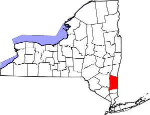 | |
| Towns | ||
| Villages | ||
| CDPs | ||
| Other hamlets | ||
| Footnotes | ‡This populated place also has portions in an adjacent county or counties | |