Titusville, New York
| Titusville, New York | |
|---|---|
| Census-designated place | |
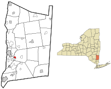 Location of Titusville, New York | |
| Coordinates: 41°39′59″N 73°51′48″W / 41.66639°N 73.86333°WCoordinates: 41°39′59″N 73°51′48″W / 41.66639°N 73.86333°W | |
| Country | United States |
| State | New York |
| County | Dutchess |
| Town | LaGrange |
| Area | |
| • Total | 0.7 sq mi (1.8 km2) |
| • Land | 0.7 sq mi (1.8 km2) |
| • Water | 0.0 sq mi (0.0 km2) |
| Elevation | 220 ft (67 m) |
| Population (2010) | |
| • Total | 811 |
| • Density | 1,174/sq mi (453.4/km2) |
| Time zone | UTC-5 (Eastern (EST)) |
| • Summer (DST) | UTC-4 (EDT) |
| Area code(s) | 845 |
| FIPS code | 36-74017 |
| GNIS feature ID | 2584296 |
Titusville is a hamlet and census-designated place in the town of LaGrange, New York, in Dutchess County.[1] As of the 2010 census, it had a population of 811.[2]
Titusville is in the southwestern part of the town of LaGrange, 5 miles (8 km) southeast of the city of Poughkeepsie. It is bordered to the south by the hamlet of Red Oaks Mill. According to the U.S. Census Bureau, the Titusville CDP has an area of 0.69 square miles (1.8 km2), all of it land.[2]
References
- ↑ U.S. Geological Survey Geographic Names Information System: Titusville, New York
- 1 2 "Geographic Identifiers: 2010 Demographic Profile Data (G001): Titusville CDP, New York". U.S. Census Bureau, American Factfinder. Retrieved November 20, 2015.
Municipalities and communities of Dutchess County, New York, United States | ||
|---|---|---|
| Cities | 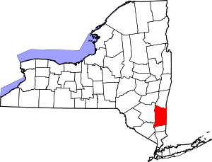 | |
| Towns | ||
| Villages | ||
| CDPs | ||
| Other hamlets | ||
| Footnotes | ‡This populated place also has portions in an adjacent county or counties | |
This article is issued from
Wikipedia.
The text is licensed under Creative Commons - Attribution - Sharealike.
Additional terms may apply for the media files.