Pictured Rocks National Lakeshore
| Pictured Rocks National Lakeshore | |
|---|---|
|
IUCN category III (natural monument or feature) | |
 | |
| Location | Alger County, Michigan, United States |
| Nearest city | Munising, Michigan |
| Coordinates | 46°33′44″N 86°18′45″W / 46.56222°N 86.31250°WCoordinates: 46°33′44″N 86°18′45″W / 46.56222°N 86.31250°W |
| Area | 73,236 acres (296.38 km2) |
| Established | October 15, 1966 |
| Visitors | 476,888 (in 2005) |
| Governing body | National Park Service |
| Website | Pictured Rocks National Lakeshore |
| Official name | Pictured Rocks |
| Designated | February 17, 1965 |
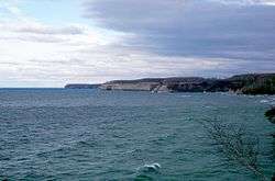
Pictured Rocks National Lakeshore is a U.S. National Lakeshore on the shore of Lake Superior in the Upper Peninsula of Michigan, United States. It extends for 42 miles (67 km) along the shore and covers 73,236 acres (114 sq mi; 296 km2). The park has extensive views of the hilly shoreline between Munising and Grand Marais in Alger County, Michigan, with picturesque rock formations, waterfalls, and sand dunes.
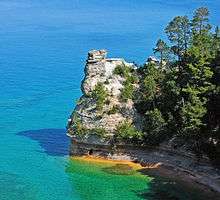
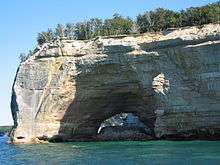
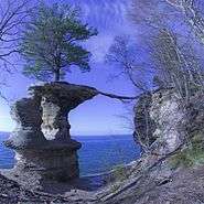
Pictured Rocks derives its name from the 15 miles (24 km) of colorful sandstone cliffs northeast of Munising. The cliffs reach up to 200 feet (60 m) above lake level. They have been naturally sculptured into a variety of shallow caves, arches, and formations resembling castle turrets and human profiles. Near Munising, visitors can also visit Grand Island, most of which is included in the separate Grand Island National Recreation Area.
The U.S. Congress designated Pictured Rocks the first National Lakeshore in the United States in 1966. It is governed by the National Park Service (NPS), with 22 year-round NPS employees as of May 2006, and received 476,888 visitors in 2005.
Geology
The colors in the cliffs are created by the large amounts of minerals in the rock. The cliffs are composed of the Munising Formation of 500-million-year-old Cambrian Period sandstone. The Munising Formation sits atop Precambrian sandstone of the Jacobsville Formation. The mottled red Jacobsville Formation is the oldest rock in the park. On top of the Munising Formation, acting as a cap over the other layers, is the hard sandstone of the younger Au Train Formation from the Ordovician Period. Streaks on the face of the cliffs come from groundwater leaching out of the rock and evaporating, leaving streaks of iron (red), manganese (black-white), limonite (yellow-brown), copper (pink-green), and other minerals.[2]
History
Although the Pictured Rocks shore waters are a rich fishing ground, the sandstone cliffs are dangerous to canoes and other open boats skirting the coastline. In 1658, the fur trader Pierre Esprit Radisson made this risky passage and noted that his Native American companions made an offering of tobacco to the local spirit of the cliffs.
During the Romantic Era of the 1800s, a series of American writers described their feelings upon sight of the Pictured Rocks. Geologist and US Indian Agent Henry Rowe Schoolcraft visited in 1820 and remarked upon "some of the most sublime and commanding views in nature".[3] In 1850, George Copway Kah-Ge-Ga-Gah-Bowh, a Mississaugas Ojibwa writer and Methodist missionary, published The Traditional History and Characteristic Sketches of the Ojibway Nation, in which he cited the detailed description of the Pictured Rock by General Lewis Cass.[4]:24–7 Around 1850, developers planned a tourist resort, Grand Island City, adjacent to the Pictured Rocks near the current site of Munising.
After the lumbering era ended around 1910, much of the land making up the current National Lakeshore reverted to the state of Michigan for unpaid property taxes. Eager for federal help and recognition, the state cooperated with the federal government in the region's redevelopment. In October 1966, Congress passed a bill authorizing the establishment of the Pictured Rocks National Lakeshore "in order to preserve for the benefit, inspiration, education, recreational use, and enjoyment of the public, a significant portion of the diminishing shoreline of the United States and its related geographic and scientific features."[5] This was America's first National Lakeshore.
On April 13, 2006, one of the named rock formations collapsed: the Inner Turret of Miner's Castle in the Munising Formation. The collapse was reported via cell phone by fisherman in the area, according to chief ranger Larry Hach. Miners Castle consists of crumbly cross-bedded sandstone poorly cemented by secondary quartz, according to Research Ecologist Walter Loope of the U.S. Geological Survey. Rockfalls along the cliffs typically occur in the spring and fall due to freezing-thawing action.
On March 30, 2009, the Omnibus Public Land Management Act was signed into law, protecting 11,740 acres (47.5 km2) of Pictured Rocks as the Beaver Basin Wilderness.[6]
Representation in other media
In 2010, singer Kid Rock filmed the video for his song "Born Free" at the Pictured Rocks National Lakeshore.[7][8]
In early 2014, Courtney Kotewa's snapshot of kayakers passing under a rock arch at the Pictured Rocks National Lakeshore was chosen as the grand prize winner of 2013 Share the Experience photo contest, sponsored by the National Park Foundation. [9][10]
Access and accessibility

Munising, on the western end of the lakeshore, is accessed by M-28 and M-94. Grand Marais, on the eastern end, is reached by M-77.
Paved highways penetrate into the Lakeshore from both ends, connected by County Road H-58. Roads come close to the shoreline only near Miners Castle, 12 Mile Beach, and the Grand Sable Dunes. The rest of the shoreline is seen from land only by hiking. A 42-mile (67-km) section of the North Country Trail spans the lakeshore. A permit is needed for backcountry camping, which is allowed along many miles of the National Lakeshore.This means that dispersed camping is not allowed in the park.
Many boat companies offer daily trips along the lakeshore from Memorial Day weekend through the fall season. Sea kayaking is another popular way to explore the park. While this may be the best way to see the natural formations, it is a strenuous trip in cold, dangerous water, not be undertaken lightly or without proper equipment. Guides are available. The most efficient port of entry for kayaks is from Miner's Beach or the harbor at Munising. In addition, pontoons can be cheaply rented locally.
Winter sports activities include cross-country skiing, snowshoeing, snowmobiling, ice climbing, and ice fishing.
The administrators of Pictured Rocks have worked to make much of its rugged environment wheelchair accessible.[11] Features include:
- Interagency Visitor Center, Munising Falls Interpretive Center, and Miners Castle Information Station in Munising
- Grand Sable Visitor Center in Grand Marais
- Each drive-in campground has at least one handicapped-accessible campsite with an extended picnic table, boardwalk, pedestal fire grate, and nearby rest room
- Log Slide overlook
- Miners Castle overlooks (except lower overlook trail, which includes stairs and is steep)
- Munising Falls viewing platform, with paved trail
- Boardwalk at Sand Point Marsh Trail, with large-print guide
- Sand Point Beach parking with paved sidewalks, fully accessible picnic site, and boardwalk toward Lake Superior[11]
Points of interest
From west (Munising) to east (Grand Marais):
- Munising Falls, Interpretive Center
- Sand Point, National Lakeshore Headquarters
- Miners Castle rock formation, paved road to overlook (suiffering major rockfall April 13, 2006)
- Miners River, emptying into Lake Superior near Miners Beach.
- Miners Falls interpretive trail
- Grand Portal Point rock formations
- Mosquito Falls
- Mosquito River
- Chapel Rock
- Chapel Falls
- Beaver Basin Wilderness
- Twelvemile Beach
- Shipwrecks
- White Birch Forest
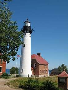
- Au Sable Point, Au Sable Light
- Log Slide
- Grand Sable Dunes
- Grand Sable Lake
- Sable Falls, Interpretive Center
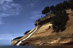
Waterfalls
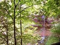
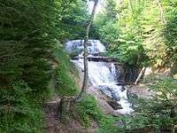
Pictured Rocks is the site of many of Michigan's waterfalls. Most of the waterfalls resulted from water running over cliffs of the Munising Formation. This lime and sandstone formation exists between Tahquamenon Falls, some 75 miles (121 km) east, to Laughing Whitefish Falls, 30 miles (48 km) west of the Lakeshore. Pets are not allowed on most of the trails.[12]
- Munising Falls—A 50-foot (15 m) waterfall over a sandstone cliff. Along the trail may be seen ferns, wildflowers, and an occasional mink. The trail is fully accessible to people with disabilities and dogs are allowed.[13]
- Miners Falls—This self-guiding interpretive trail passes Miners Basin and ends at Miners Falls. There are 77 steps leading down to the viewing platform. The falls drops 50 feet (15 m) over the sandstone outcrop.[13]
- Bridalveil Falls—Bridalveil is a seasonal waterfall. In the summer, it may not exist or be only a trickle.[13]
- Mosquito Falls—This falls drops over an 8-foot (2.4 m) rock shelf on the Mosquito River. River otters and beavers live in the stream along the trail.[13]
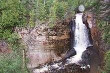
- Chapel Falls—Two viewing platforms along the way provide views of the scenic Chapel Basin. Chapel Falls cascades some 60 feet (18 m) down the sandstone cliffs on its way to Chapel Lake.[13]
- Spray Falls—This waterfall is best seen from Lake Superior. The 1856 shipwreck of the Superior is at the base of the falls in 20 feet (6.1 m) of water.[13]
- Sable Falls - Sable Falls tumbles 75 feet (23 m) over several cliffs of Munising and Jacobsville sandstone formations on its way to Lake Superior.[13]
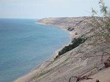
Grand Sable Dunes
The Grand Sable Dunes, at the eastern end of the Lakeshore, are a perched dune formation. Sand washed ashore by wave action was then blown upslope by northerly prevailing winds until it came to rest atop a glacial moraine. The Grand Sable Dunes today form a sand slope that rises from Lake Superior at a 35° angle. The summits of the tallest dunes are as high as 275 feet (85 m) above lake level.
Climate and weather
| Climate data for Grand Marais, Michigan | |||||||||||||
|---|---|---|---|---|---|---|---|---|---|---|---|---|---|
| Month | Jan | Feb | Mar | Apr | May | Jun | Jul | Aug | Sep | Oct | Nov | Dec | Year |
| Average high °F | 25.3 | 27.4 | 36.4 | 49.2 | 62.1 | 70.4 | 75.9 | 74.8 | 67 | 55.8 | 41.5 | 29.7 | 51.3 |
| Average low °F | 11.2 | 10.6 | 17.9 | 29.3 | 37.9 | 45.7 | 51.9 | 52.8 | 47.1 | 38 | 28.2 | 17 | 32.3 |
| Average rainfall inches | 2.3 | 1.4 | 1.6 | 1.6 | 2.5 | 2.9 | 2.5 | 3.2 | 3.6 | 3 | 2.6 | 2.5 | 29.8 |
| Average snowfall inches | 47.3 | 30.7 | 16 | 4.8 | 0.3 | 0.0 | 0.0 | 0.0 | 0.0 | 0.9 | 12.6 | 41.7 | 154.2 |
| Average high °C | −3.7 | −2.6 | 2.4 | 9.6 | 16.7 | 21.3 | 24.4 | 23.8 | 19 | 13.2 | 5.3 | −1.3 | 10.7 |
| Average low °C | −11.6 | −11.9 | −7.8 | −1.5 | 3.3 | 7.6 | 11.1 | 11.6 | 8.4 | 3 | −2.1 | −8 | 0.2 |
| Average rainfall mm | 58 | 36 | 41 | 41 | 64 | 74 | 64 | 81 | 91 | 80 | 66 | 64 | 757 |
| Average snowfall cm | 120.1 | 78 | 41 | 12.2 | 0.8 | 0 | 0 | 0 | 0 | 2.3 | 32 | 105.9 | 391.7 |
| Source: [14] | |||||||||||||
References
- ↑ Hach, Larry (April 14, 2006). "Miners Castle Turret Collapses". Pictured Rocks National Lakeshore. Retrieved April 24, 2012.
- ↑ "Pictured Rocks National Lakeshore, Michigan"; Park brochure, published Harpers Ferry, West Virginia; 2002
- ↑ Schoolcraft, Henry R. (1821). Narrative Journal of Travels through the Northwestern Regions of the United States, p. 150. E. & E. Hosford.
- ↑ The Traditional History and Characteristic Sketches of the Ojibway Nation. 1850. Retrieved February 17, 2018.
- ↑ The Pictured Rocks: An Administrative History of Pictured Rocks National Lakeshore (Table of Contents)
- ↑ "Beaver Basin Wilderness", National Park Service; Accessed 9-28-2011.
- ↑ "Kid Rock "Born Free" Video at Pictured Rocks". National Park Service. November 2010. Retrieved 14 December 2011.
- ↑ Anderson, Kyle; Kash, Tim (4 November 2010). "MTV news article with link to video: Kid Rock Goes Majestic in Born Free Video". MTV News. Retrieved 14 December 2011.
- ↑ "Northern Michigan To Be Featured On National Parks Pass | Michigan Radio". Michigan Radio and Interlochen Public Radio. May 2, 2014. Retrieved 4 May 2014.
- ↑ "2013 Share The Experience Photo Contest | National Park Foundation". National Park Foundation. 2014. Retrieved 4 May 2014.
- 1 2 Pictured Rocks Accessibility
- ↑ Waterfalls
- 1 2 3 4 5 6 7 Waterfalls site bulletin, Pictured Rocks NL, Munising, Michigan
- ↑ "Weatherbase: Historical Weather for Grand Marais, Michigan". Retrieved June 5, 2009.
Further reading
- Stonehouse, Frederick. Dangerous Coast: Shipwrecks of Pictured Rocks, Avery Color Studios, June 1997. ISBN 0-932212-93-X.
External links
| Wikimedia Commons has media related to Pictured Rocks National Lakeshore. |
- NPS Site
- UP Trails Guide
- Accessibility information from The Disabled Traveler's Companion
- Michigan Interactive Tour of Pictured Rocks
- Additional photos of Pictured Rocks
| Central cities | |
|---|---|
| Counties | |
| Geography | |
| Transportation | |
| Economy | |
| Main lakes |  | |
|---|---|---|
| Secondary lakes | ||
| Bays and Waterways |
| |
| Islands | ||
| Historic geology | ||
| Government | ||
| Related topics | ||